| 2018 Lower Puna eruption | |
|---|---|

ʻAʻā lava flows emerging from the elongated fissure 16-20 form channels on May 19, 2018 | |
| Volcano | Kīlauea's Lower East rift zone |
| Start date | May 3, 2018 |
| End date | September 4, 2018 |
| Type | Fissure eruption |
| Location |
Hawaii Island,
Hawaii, United States 19°27′47″N 154°53′56″W / 19.463°N 154.899°W |
| Impact | 24 injuries; lava fountains, lava flows; at least $800 million (2018 USD) in property damage; volcanic gas and earthquakes forced the evacuation of populated areas and destroyed houses, roads, and utilities. [1] |


The 2018 lower Puna eruption was a volcanic event on the island of Hawaiʻi, on Kīlauea volcano's East Rift Zone that began on May 3, 2018. It is related to the larger eruption of Kīlauea that began on January 3, 1983, though some volcanologists and USGS scientists have discussed whether to classify it as a new eruption. [2] Outbreaks of lava fountains up to 300 feet (90 m) high, lava flows, and volcanic gas in the Leilani Estates subdivision were preceded by earthquakes and ground deformation that created cracks in the roads.
On May 4, a 6.9 magnitude earthquake hit Puna. By May 27, 2018, 24 fissures had erupted lava in and near the Leilani Estates and Lanipuna Gardens subdivisions. [3] [4] The eruption forced the evacuation of approximately two thousand residents. The Puna Geothermal Venture, which provided one-quarter of the island's electricity, was forced to shut down and was later damaged by lava. The fissures had sent lava rivers that buried part of Hawaii Route 137 on May 19, and began flowing into the ocean. [5]
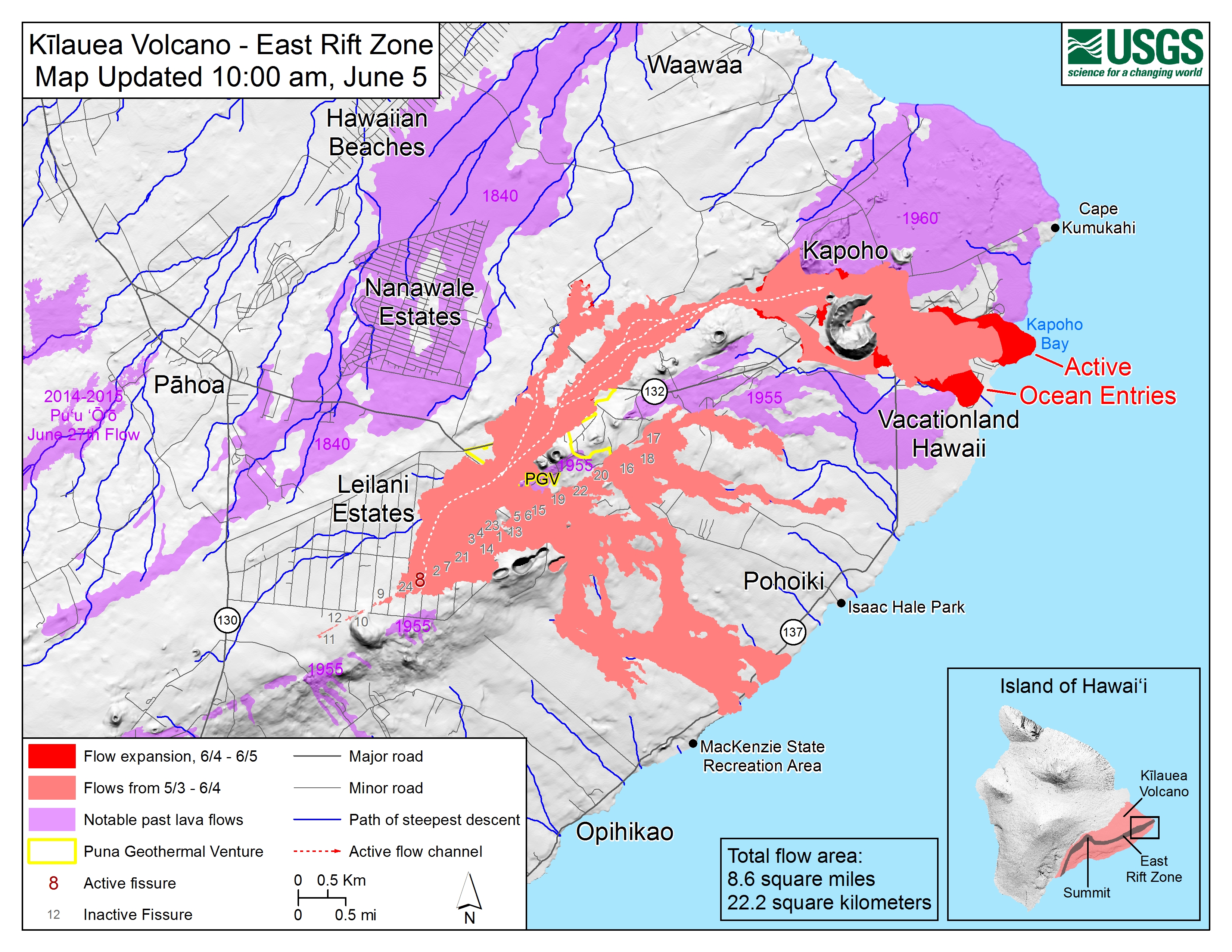
On May 29, lava from a new northeastern flow overran Hawaii Route 132, cutting the access between Kapoho and Pāhoa. [6] The massive lava flow reached the Pacific Ocean at Kapoho Bay on June 4. [7] [8] Lava entered the Kapoho Crater and evaporated Green Lake, which had been the largest natural freshwater lake in Hawaiʻi. On the night of June 4–5, the northeastern flow of lava speedily moved forward and destroyed the subdivision of Vacationland Hawaii. [9] By June 5, Kapoho Bay had been filled in with lava now forming a point where the bay had been. [10] The volcanic activity was the most destructive in the United States since the 1980 eruption of Mount St. Helens. [11]
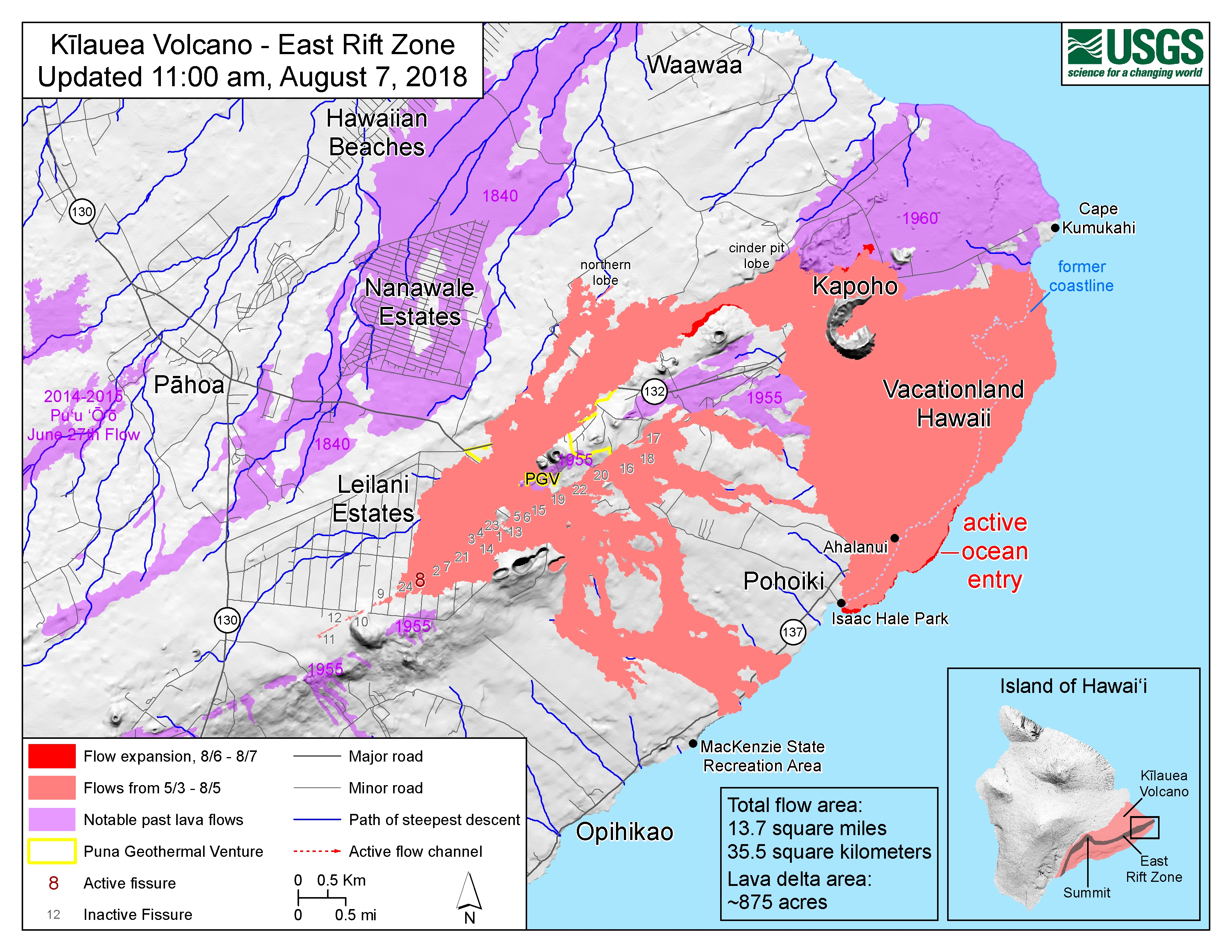
By August 7, 13.7 square miles (35 km2) of land had been covered by lava flows. About 875 acres (3.54 km2) of new land has been created in the ocean. [12] [13] The official number of houses destroyed by the eruption reached 700 on July 9. [14] It was estimated that recovery efforts would cost more than $800 million (2018 USD). [15] By early August the eruption had almost completely subsided, and on December 5, it was declared to have ended after three months of inactivity. [16]
Background
The volcanic event in Puna was the 62nd episode of Kīlauea's east rift zone eruption that began in January 1983. Puʻu ʻŌʻō had become a prominent volcanic cone 12 mi (19 km) east of the summit caldera of Kīlauea, since the 1983 eruption's beginning. In the 1980s and 1990s, Puʻu ʻŌʻō produced lava flows that destroyed the nearby Royal Gardens subdivision and the settlement of Kapaʻahu. In 1990, lava flows from the Kūpaʻianahā vent of Kīlauea, downrift from Puʻu ʻŌʻō, destroyed and partly buried most of the nearby towns of Kalapana and Kaimū. [17] [18]
On April 30, 2018, the crater floor of the cone of Puʻu ʻŌʻō collapsed and the summit lava lake level in Halemaʻumaʻu dropped significantly. In the first two days of May, hundreds of small earthquakes were detected on Kīlauea's East rift zone, leading officials to issue evacuation warnings for some residents of the Puna District. [19] On May 2, 2018, the US Geological Survey reported that ground deformation resulting from magma intruding beneath the Leilani Estates subdivision had caused ground cracks to form on roads in and around the subdivision. [20] [21]
In connection with the eruption and its possible effects on the Hilina Slump, the Hawaiian Volcano Observatory published information concluding that the chance of a catastrophic collapse would be incredibly remote. [22]
Eruption
Earthquakes and Leilani Estates fissures
On May 3, 2018, after a 5.0 earthquake earlier in the day, steaming ground cracks opened in Leilani Estates and began to spew lava, causing evacuations of the Leilani Estates and Lanipuna Gardens subdivisions. [23] [24] The outbreak marked the beginning of the 62nd episode of the east rift zone eruption that began in January 1983. [24] That evening, Hawaii Governor David Ige activated the state National Guard to help with the evacuation process. [25]
The next day, May 4, two homes were reported destroyed in Leilani Estates from three erupting vents. [25] The Hawaii County Civil Defense Agency reported high levels of toxic sulfur dioxide gas in the area, and Talmadge Magno, the Civil Defense Administrator for Hawaiʻi County, stated that power lines had melted off poles from the heat. [26] [27] The Puna Geothermal Venture (PGV), a power station, was shut down on 22 May 2018; [28] the geothermal power plant provided approximately 25% of the Big Island's power, but its shutdown was later stated not to present a risk to power on the island. A Temporary Flight Restriction area was declared by the FAA to restrict flights below 3,000 feet AGL in the eruption area. [25]
A 6.9 magnitude earthquake occurred on May 4 [29] that the United States Geological Survey said was related to the eruptions. [30] The earthquake was the strongest to hit the state since 1975. [31] On May 6, Hawaiʻi County Civil Defense reported that 26 houses had been destroyed by lava or fires in Leilani Estates. [32] Lava fountains up to 300 feet (90 m) were observed in the subdivision. [33] The lava vents formed a northeast–southwest line; [31] officials were concerned about potential damage to a water main in the area. [34]
On May 7, 1,700 people had been ordered to evacuate their homes. Two hundred residents and their pets were in two Red Cross shelters and hundreds more were staying with family and friends. Several first responders were sickened by sulfur dioxide gas. [35]
Also on May 7, the International Charter on Space and Major Disasters was activated, for humanitarian use of satellite data. [36] (The USGS used Sentinel2 and Arirang-2.) [37]
By May 9, another home had been destroyed, along with other structures. [38] The fifteenth fissure opened near the entrance to Lanipuna Gardens and added more lava to the nearly 117 acres (47 ha) covered since May 3. [39]
-
![Ash from Kilauea Eruption, right image shows the height of the plume by color.[40]](https://upload.wikimedia.org/wikipedia/commons/thumb/d/d2/NASA-K%C4%ABlauea2018-Plume.jpg/374px-NASA-K%C4%ABlauea2018-Plume.jpg) Ash from Kilauea Eruption, right image shows the height of the plume by color. [40]
Ash from Kilauea Eruption, right image shows the height of the plume by color. [40] -
![Blue flames from burning methane gas in Leilani Estates, on 22 May 2018, 11:30 p.m. HST.[41]](https://upload.wikimedia.org/wikipedia/commons/thumb/8/84/Kilauea-May2018Eruption-BlueMethaneFlames.jpg/374px-Kilauea-May2018Eruption-BlueMethaneFlames.jpg) Blue flames from burning methane gas in Leilani Estates, on 22 May 2018, 11:30 p.m. HST. [41]
Blue flames from burning methane gas in Leilani Estates, on 22 May 2018, 11:30 p.m. HST. [41] -
Aerial view of fissure 17 on May 14 around 4:30 p.m. HST.
-
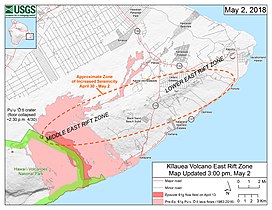 Map of ongoing intrusion and earthquake activity along Kīlauea's East Rift Zone (May 2, 2018)
 -
![Collapse in the crater of Puʻu ʻŌʻō,[42] creating an ash plume (May 3, 2018)](https://upload.wikimedia.org/wikipedia/commons/thumb/d/d5/USGS_K%C4%ABlauea_multimediaFile-1936.jpg/315px-USGS_K%C4%ABlauea_multimediaFile-1936.jpg) Collapse in the crater of Puʻu ʻŌʻō, [42] creating an ash plume (May 3, 2018)
Collapse in the crater of Puʻu ʻŌʻō, [42] creating an ash plume (May 3, 2018) -
 Eruption in the Leilani Estates subdivision (May 3, 2018)
 -
 A lava flow moves on Makamae Street in Leilani Estates at 09:32 am HST on May 6
 -
 Map of the locations of eruptive fissures (May 5, 2018)
![Ash from Kilauea Eruption, right image shows the height of the plume by color.[40]](/info/en/?search=File:NASA-K%C4%ABlauea2018-Plume.jpg)
![Blue flames from burning methane gas in Leilani Estates, on 22 May 2018, 11:30 p.m. HST.[41]](/info/en/?search=File:Kilauea-May2018Eruption-BlueMethaneFlames.jpg)

![Collapse in the crater of Puʻu ʻŌʻō,[42] creating an ash plume (May 3, 2018)](/info/en/?search=File:USGS_K%C4%ABlauea_multimediaFile-1936.jpg)


New eastern fissures, lava flows reach sea
On May 12, a 16th fissure opened in Lower Puna, which spattered lava in an area east of Puna Geothermal Venture. [43] [44]
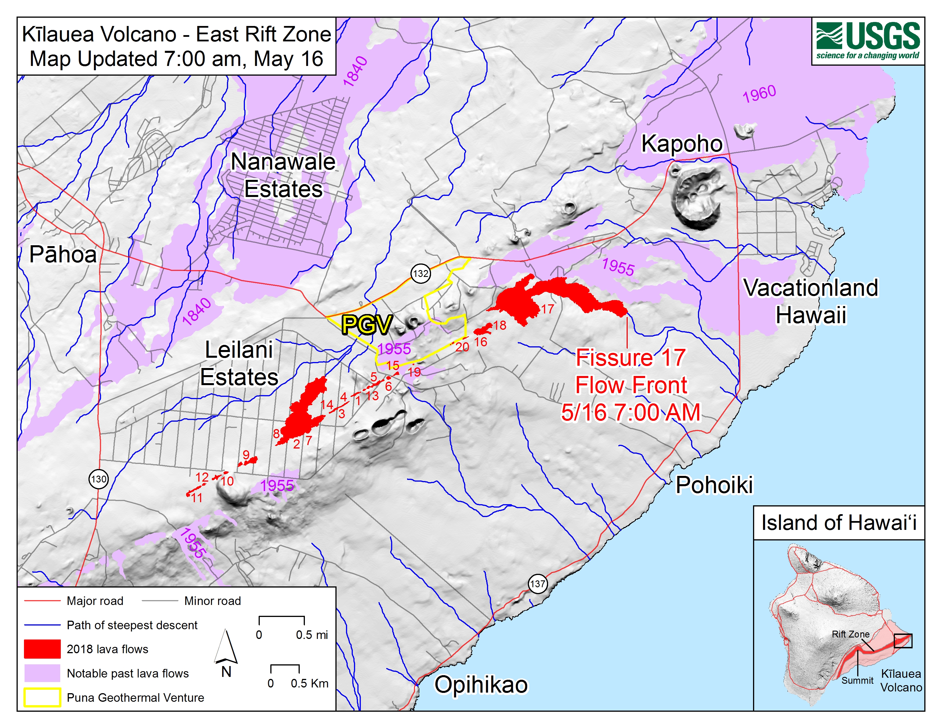
A 17th fissure opened east of the 16th fissure later that day. As of May 14, 2018, lava flows from fissure 17 had traveled just under a mile from the vent, [4] destroying an additional structure and leading officials to advise residents in an area known as Four Corners to evacuate due to the possibility that lava from a future fissure could cut Highway 132 and eventually Highway 137 as well. A spokeswoman for the mayor also reported that the chemistry of the lava was changing in later fissures, containing a mixture of more viscous old lava and faster-moving new magma. [45] Fissure 17 was unusual in that it erupted Kīlauea's first documented andesitic lava, a composition that is higher in silica and more viscous than the basalt that Kīlaeua normally produces. The higher viscosity resulted in more explosive activity than at other fissures. [46]
By May 16, there were 20 fissures. [47] That day the ash plume from the summit reached 12,000 feet. On May 17, an eruption from the summit sent an ash cloud 30,000 feet high. A 21st fissure opened and several magnitude 3 earthquakes damaged the road near the entrance to Hawaiʻi Volcanoes National Park and some of the park buildings. [48] On May 17, at approximately 4:15 a.m., an explosive eruption occurred at Halemaʻumaʻu, creating a plume of ash 30,000 feet into the air. [49] On May 19 some of the fissures had merged into a line of fountaining lava, with a lava flow that split into separate lobes. At least two of these flows crossed through parts of Malama Kī Forest Reserve, blocked Highway 137, and flowed into the Pacific Ocean at Malama flats near MacKenzie State Recreation Area on May 19, producing clouds of irritating " laze" (lava haze), made up of steam, hydrochloric acid, and volcanic glass particles produced by littoral explosions. [50] Warnings regarding the hazard were issued for communities downwind of the lava's ocean entry points. [51] [5] [3]
By May 22, splashes from fissure 22's lava cone had engulfed the former Hawaiʻi Geothermal Project site adjacent to the PGV and was reported to be threatening the grounds of the PGV proper from the south until activity at fissure 22 slowed. [52]
-
May 19 Fissure 20 Lava flow as seen by USGS from a helicopter
-
Spattering and lava flow at fissure 20 in Kīlauea Volcano's Lower East Rift Zone
-
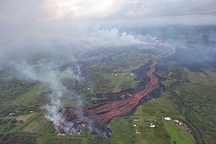 Lava emerges from the elongated fissure 16–20
 -
 Lava from the Fissure 20 complex is entering the ocean in two locations
 -
 Hot lava entering the ocean creates a dense white plume
 -
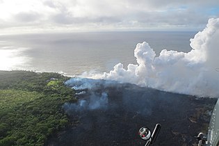 Ocean entry and wildfires
 -
 Coastal area
 -
 Lava fountains at fissure 22
 -
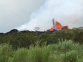 Lava fountain at fissure 22, from the north side of the fissure complex
 -
 Lava channels flowing southward from the fissure
 -
 Lava enters the sea at two locations after crossing Hawaii Route 137


Reopening of Leilani Estates fissures and new northeastern lava flow
From May 23, eruptions at the eastern fissures began to weaken considerably, as lava activity moved back up the rift zone; older fissures reopened to release fluid pāhoehoe, which rapidly replaced the output of ʻaʻā, and led to massive pooling of lava over lower Leilani Estates. On the same day, fissures 5, 13, and 15 began to form lava fountains around the Leilani Avenue-Kahukai Street intersection. Fissures 3, 7, 8, 9, 21 and 23 farther up the rift zone would experience intermittent but lively activity between May 24 to May 27 as the center of activity moved to fissure 7. A 24th fissure would also form farther up the fissure complex on May 27, between fissures 8 and 9. Due to continued encroachment by lava, the number of destroyed structures was revised upward to 82 on May 25. [53] The area of land covered by the 2018 lava on May 25, 2018, reached 2,223 acres. [54] The eastern fissures would experience limited resurgences in activity into June and July.
The pool of lava in Leilani Estates eventually spilled eastwards into two paths, one short-lived route running southeast parallel to lava channels headed for the ocean, and another travelling northeast, crossing Pohoiki Road over the western boundaries of the Puna Geothermal Venture. [55] On May 27, one of the 11 geothermal wells at the PGV was covered by the advancing lava flow from the Leilani Estates fissures, [56] [57] the first time lava had covered a geothermal well, [58] followed by a second well hours later, along with ten more structures in the adjacent Leilani Estates. [59]
As the lava flow from Leilani Estates intensified by the end of May, activity shifted to ʻAhuʻailāʻau (initially designated Fissure 8) [60] as nearly all surrounding fissures ceased to release lava. ʻAhuʻailāʻau's lava fountains rapidly formed a new spatter cone, increasing the volume of pooling lava over the course of the week and feeding the northeastern flow further. By May 29, the northeastern flow approached Hawaii Route 132, which linked Pāhoa and Kapoho, blocking the access road to the PGV and forcing the closure of Route 132 between the Lava Tree State Park from the west and the Four Corners intersection to the east. [61] The lava flow covered a section of the highway later that day, [6] before travelling farther east in the direction of Kapoho. The northeastern lava flow also cut power to Kapoho and nearby developments including Vacationland Hawaiʻi, and surviving sections of Leilani Estates and Lanipuna Gardens. It was not known how and when power to those communities could be restored. [62]
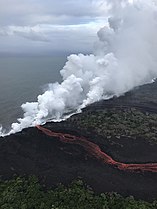
By the morning of June 3, the lava flow from ʻAhuʻailāʻau had reached Kapoho and Vacationland Hawaiʻi, where it then destroyed hundreds of houses as it buried most of the town within a day. Lava also entered the Puʻu Kapoho crater and evaporated the 400-year old Green Lake inside the crater, the largest natural freshwater lake in Hawaiʻi. [63] The flow entered the ocean at Kapoho Bay at about 10:30 PM HST that evening, creating plumes of laze, and began to fill the bay, building a lava delta that reached about 700 yards into the water by late afternoon on June 4. By June 5, the lava had completely filled the bay, and preliminary reports from Hawaiʻi County officials indicated that hundreds of homes had been destroyed. [64]
In addition to the draining of Puʻu ʻŌʻō, the protracted release of lava along the Lower East Rift Zone has also led to significant drainage of lava away from Halemaʻumaʻu at Kīlauea, resulting in large scale inward slumping and collapse around the crater and regular earthquakes since May 17, similar in pattern to the crater's slumping during the 1924 event. [65] Explosions or mild earthquakes of similar magnitude became an almost daily cyclical occurrence at the summit, and have also been reported to influence the intensity of lava surges at ʻAhuʻailāʻau. [66] [67]
Transition to steady lava effusion, and eventual end
By the middle of June 2018, lava eruption from the source in Leilani Estates reached a consistently vigorous rate, flowing in the direction of Kapoho Bay and forming a widening coastal lava field. [7] [8] [68] By July 3, fissure 8's constant lava splatter created a cone that peaked at 180 feet (50 m) high. [69] [70] A total of 5,914 acres were reported by Hawaii Civil Defense to have been covered by lava, with 533 homes confirmed destroyed. [71] On June 22, the number of houses covered by lava was revised upwards by Hawaii County Civil Defense to 614. [72] By July 1, that total had grown to 671 residences destroyed. [73] The official toll of houses reached 700 on July 9, leaving 3 houses left standing in Kapoho. [14] On July 13, geologists reported a tiny new island had appeared immediately offshore from the lava flow. The island was only 20 to 30 ft (6.1 to 9.1 m) across and may have formed as a submarine tumulus pushed up the outermost crust of the earth above sea level. [74] It was connected to the mainland by an isthmus on July 16. [75] [76]
In mid-July, the main stream of lava from ʻAhuʻailāʻau changed course away from flowing around the northeast of Puʻu Kapoho crater following a breakout from a lava pond on July 9, redirecting to a new channel that traveled in a more direct southerly direction west of Puʻu Kapoho. The flow would cover more of the 1955 lava flow, and destroy more coastal features including Ahalanui Beach Park, its warm ponds, as well as Kua O Ka Lā Public Charter School's Lower Puna compound on July 11. [77] [78] By July 24, 2018, the western boundaries of the lava spill was within 200 yards (180 m) of Isaac Hale Beach Park. [79]
As of July 21, 2018, the lava flow from ʻAhuʻailāʻau was estimated to be a steady 26,000 US gallons per second (98 m3/s), according to the U.S. Geological Survey, which also stated that the most likely scenario was that lava effusion would continue at a steady rate for several months to two years. By mid-July 2018, the volume of lava had exceeded the volume deposited in the eruptions of 1955 or 1960. [80]
Eruption activity at ʻAhuʻailāʻau began to see a downtrend beginning on August 5, 2018, as the intensity of both the lava channel and seismic activity at Halemaʻumaʻu decreased significantly over the course of the following days. Within the same time frame, the USGS reported that Puʻu ʻŌʻō was venting gases at its highest rate in more than 10 years, though no other noticeable changes had taken place at the vent. [81] On August 15, 2018, the lower east rift zone eruption was reported to have subsided, with no new lava entering the channel from ʻAhuʻailāʻau in over a week. While scientists cautioned that the eruption could resume at any time, in that week there was no further underground volcanic inflation registering on instruments, and no further summit collapse events, with only a small amount of lava active inside ʻAhuʻailāʻau. [82] Afterward, a small lava lake was maintained within the crater of the ʻAhuʻailāʻau cone for another 3 weeks. On September 4, the lava lake in ʻAhuʻailāʻau receded below the surface, bringing the eruption to an end. [16]
Impact and response
The Hawaii National Guard stated on May 11, 2018, that they were ready to evacuate up to 2,000 people at a moment's notice, through the use of land convoys and Blackhawk and Chinook helicopters. Hawaii Governor David Ige had made a request for a Presidential Disaster Declaration, which was approved that day and opened the door to federal assistance for the disaster. [43] Starting May 23, two CH-53E Super Stallion helicopters were on standby in Hilo in case of sudden evacuation needs. The U.S. Marine Corps helicopters were in support of Joint Task Force 5–0, a military/government partnership to assist in managing the disaster. The large heavy-lift helicopters have a carrying capacity of about 50 people at once, ensuring that residents south of the lava flow can be completely evacuated in a few hours, should the last functioning road out of the area south of the lava flow be cut off by the eruption. [83]
As the area of destruction grew significantly as a result of ʻAhuʻailāʻau's resurgence in late-May 2018, access to surviving sections of Leilani Estate within immediate proximity to the margins of the lava field began to be heavily restricted starting May 31. [84] A proposed ban on future home construction in areas subject to high-risk of volcanic activity was also reported on July 1, 2018, to be in discussion by Hawaii politicians. [73]
Temporary repair works were conducted for sections of Highway 11 (near Volcano Village and the entrance to Volcanoes National Park) and Highway 130 (connecting much of lower Puna to the rest of the island), which suffered cracks from seismic activities over the months, and have been subject to restricted use due to the extent of their damage. [85] Chain of Craters Road, which has previously been partially covered by past lava flows, had also been prepared as an alternate escape route should Highway 130 be blocked by the current eruption, a measure previously taken during the 2014 Pāhoa lava flow. [86]
In early June, a Winter Weather Advisory alert was issued for the higher areas of the island due to freezing rain and ice falling. The quantity of lava reaching the ocean created large plumes of steam which rose high enough in the atmosphere to eventually condense and freeze before falling on the summit of Mauna Kea, 45 miles (72 km) from the eruption. [87]
Sporadic incidents of injuries and emergency rescues have been reported over the course of the eruption. The first known injury was reported on May 20, 2018: A homeowner was struck with a piece of "lava spatter" and suffered burns and a broken leg. [88] Four people were evacuated by helicopter on May 19, after lava cut off their exit, [89] and three people were airlifted on June 3 from the Kapoho area. [90] On July 16, a further 23 were injured when a tour boat carrying passengers observing a lava ocean entry was pelted by lava rocks thrown by an intense hydrovolcanic explosion, including a large lava rock that pierced through the boat's roof. Thirteen were treated at the hospital, including three who were admitted with unspecified injuries and one in serious condition with a broken thigh bone. [1]
Hawaii County's Voluntary Housing Program provides buyouts based on land values before the disaster to home and property owners. Hundreds of people in the impacted areas applied for the program. [91]
-
 FEMA team sets up a mobile air quality monitoring station
 -
 US Geological Survey volunteer tests for sulfur dioxide
 -
 Marine Super Stallion standing by in event of evacuation


References
- ^ a b "23 Hurt After Lava From Hawaii Volcano Flies Through Roof of Tour Boat". Time. Archived from the original on July 17, 2018. Retrieved July 17, 2018.
- ^ Dayton, Kevin (May 31, 2018). "Scientists debate whether Leilani Estates eruption is 'new'". Star Advertiser. Archived from the original on June 13, 2018. Retrieved June 1, 2018.
- ^ a b Pang, Gordon Y.K. (May 19, 2018). "4 rescued by helicopter as lava cuts off access to about 40 houses". Honolulu Star-Advertiser. Archived from the original on May 20, 2018. Retrieved May 20, 2018.
- ^ a b "HAWAIIAN VOLCANO OBSERVATORY DAILY UPDATE (KILAUEA VOLCANO), Monday, May 14, 2018, 8:36 AM HST". May 14, 2018. Archived from the original on May 19, 2018. Retrieved May 14, 2018.
- ^ a b "Lava crosses Highway 137 and enters the ocean in lower Puna". Hawaii Tribune-Herald. May 19, 2018. Archived from the original on May 20, 2018. Retrieved May 20, 2018.
- ^ a b Burnett, John. "Fast-moving lava crosses Highway 132 in lower Puna". Hawaii Tribune-Herald. Archived from the original on May 30, 2018. Retrieved May 30, 2018.
- ^ a b "Fissure 8 lava flow moving north; laze creating plume at Kapoho Bay". Honolulu Star-Advertiser. June 3, 2018. Archived from the original on February 16, 2022. Retrieved June 4, 2018.
- ^ a b "Managing Director: Some residents defying voluntary evacuation order in Kapoho". Hawaii Tribune-Herald. Archived from the original on June 12, 2018. Retrieved June 4, 2018.
- ^ Bernardo, Rosemarie (June 5, 2018). "Lava destroys Big Isle mayor's home". Honolulu Star-Advertiser. Archived from the original on June 6, 2018. Retrieved June 5, 2018.
- ^ "Kīlauea lower East Rift Zone lava flows and fissures, June 5, 10:00 a.m. HST". USGS. June 5, 2018. Archived from the original on June 12, 2018. Retrieved June 6, 2018.
- ^ Sylvester, Terray (June 8, 2018). "Rivers of lava destroy 600 homes on Hawaii's Big Island: mayor". Reuters. Archived from the original on June 8, 2018. Retrieved June 8, 2018.
- ^ "Photo & Video Chronology". USGS. June 13, 2018. Archived from the original on July 13, 2018. Retrieved May 7, 2018.
- ^ "East Rift Zone map". USGS. August 7, 2018. Archived from the original on August 8, 2018. Retrieved August 8, 2018.
- ^ a b Burnett, John. "Official count of homes destroyed reaches 700". Hawaii Tribune-Herald. Archived from the original on July 10, 2018. Retrieved July 10, 2018.
- ^ Kevin Dayton (September 1, 2018). "Recovery from Kilauea eruption might cost $800M". Star Advertiser. Archived from the original on September 2, 2018. Retrieved September 1, 2018.
- ^ a b "Kilauea's eruption is technically over. But that doesn't mean it won't start up again". hawaiinewsnow.com. Archived from the original on March 28, 2019. Retrieved December 6, 2018.
- ^ "Hawaiian Volcano Observatory Daily Update, U.S. Geological Survey; Tuesday, May 1, 2018, 8:49 AM HST". United States Geological Survey. May 1, 2018. Archived from the original on May 4, 2018.
-
^ Rubin, Ken.
"A Brief History of the Pu'u O'o Eruption". Hawaii Center for Volcanology.
Archived from the original on August 5, 2012. Retrieved May 11, 2018.
site last updated on 3 Jan 2016. Produced with assistance from personal accounts of Mike Garcia, HVO reports, and published scientific literature.
- ^ Baynes, Chris (May 2, 2018). "Hawaii volcano could erupt after 250 earthquakes recorded in 24 hours". The Independent. Archived from the original on May 6, 2018. Retrieved May 6, 2018.
- ^ "Photo and Video Chronology". USGS: Volcano Hazards Program HVO Kilauea. US Geological Survey. Archived from the original on July 13, 2018. Retrieved May 7, 2018.
- ^ Wong, Alia (May 11, 2018). "Madame Pele's Grip on Hawaii". The Atlantic. Archived from the original on May 10, 2018. Retrieved May 11, 2018.
- ^ "Hawaiian Volcano Observatory". Volcano Hazards Program. Archived from the original on May 7, 2018. Retrieved May 7, 2018.
- ^ Brestovansky, Michael (May 3, 2018). "Ige signs emergency proclamation following Leilani lava eruption". Hawaii Tribune-Herald. Archived from the original on May 5, 2018. Retrieved May 5, 2018.
- ^ a b "What a day! Eruptions, earthquakes, and a lower lava lake". Volcano Watch. Hawaiian Volcano Observatory, US Geological Survey. May 6, 2018. Archived from the original on May 8, 2018. Retrieved May 7, 2018.
- ^ a b c "Overnight, earthquakes and lava become the new norm on Hawaii island". Honolulu Star-Advertiser. May 3, 2018. Archived from the original on May 4, 2018. Retrieved May 5, 2018.
- ^ Consillio, Kristen (May 4, 2018). "Volcanic gas a 'risk for everyone' in the area near lava outbreak". Honolulu Star-Advertiser. Archived from the original on May 6, 2018. Retrieved May 7, 2018.
- ^ "Kilauea: Hawaii emergency declared over volcano eruption". BBC News. May 4, 2018. Archived from the original on May 4, 2018. Retrieved May 4, 2018.
- ^ "Kraftwerk wegen Lava stillgelegt: Spalt nur 200 Meter entfernt". orf.at (in German). May 22, 2018. Archived from the original on May 22, 2018. Retrieved May 22, 2018.
- ^ "M 6.9 – 16km SW of Leilani Estates, Hawaii". earthquake.usgs.gov. Archived from the original on May 5, 2018. Retrieved May 4, 2018.
-
^ The "lurch" from this quake was from pressure on the east rift zone from the magma intrusion.,
"Archived copy".
Facebook. Archived from the original on May 22, 2018. Retrieved May 22, 2018.
{{
cite web}}
: CS1 maint: archived copy as title ( link) CS1 maint: bot: original URL status unknown ( link); Tectonic Summary: [...] This earthquake was directly associated with activity at Kilauea, and the evolution of its rift system. [...], "M 6.9 – 16km SW of Leilani Estates, Hawaii (2018-05-04 22:32:54 UTC)". earthquake.usgs.gov. Archived from the original on May 5, 2018. Retrieved May 25, 2018. - ^ a b Wang, Amy; Kerr, Breena (May 7, 2018). "'Pele's the boss': Hawaii residents ride out uncertainty as lava devours more Big Island homes". The Washington Post. Archived from the original on May 8, 2018. Retrieved May 8, 2018.
- ^ "Gov. David Ige to meet with officials on Hawaii island over volcano relief". Honolulu Star-Advertiser. May 6, 2018. Archived from the original on May 7, 2018. Retrieved May 9, 2018.
- ^ Graff, Amy (May 7, 2018). "Lava fountains spew 300 feet into the air on Hawaii in volcano eruption". SFGate. Archived from the original on May 7, 2018. Retrieved May 8, 2018.
- ^ Evans, Carter (May 6, 2018). "Hawaii Kilauea volcano eruption: Lava flows, toxic gas show no signs of slowing down". CBS News. Archived from the original on May 6, 2018. Retrieved May 7, 2018.
- ^ Domonoske, Camila (May 7, 2018). "Photos: Fissures, Lava Flow and Evacuations Continue on Hawaii's Big Island". KQED. Archived from the original on May 8, 2018. Retrieved May 8, 2018.
- ^ n/a, n/a (May 7, 2018). "Earthquake and eruption of Kīlauea Volcano in the United States". International Charter on Space and Major Disasters. Archived from the original on May 23, 2018. Retrieved May 22, 2018.
- ^ ESA [@@ESA_EO] (May 15, 2018). "Updated #Kīlauea interferogram May 7–13, 6 PM local time: after the eruption of the volcano & a 6.9 earthquake the @DisastersChart was activated ➡️ @USGS used #Sentinel1 & #Sentinel2 for monitoring" ( Tweet) – via Twitter.
- ^ "Lava claims 36 structures, mostly homes, in Leilani Estates". Honolulu Star-Advertiser. May 8, 2018. Archived from the original on May 9, 2018. Retrieved May 11, 2018.
- ^ Callis, Tom (May 9, 2018). "Fissure opens near Lanipuna Gardens, bringing total to 15". Hawaii Tribune-Herald. Archived from the original on May 10, 2018. Retrieved May 9, 2018.
- ^ "Ash from Kilauea Eruption Viewed by NASA's MISR". NASA. May 6, 2018. Archived from the original on May 11, 2018. Retrieved May 12, 2018.
-
^
"Kilauea Photo & Video Chronology". Hawaiian Volcano Observatory. U.S. Geological Survey. May 23, 2018.
Archived from the original on July 7, 2018. Retrieved July 7, 2018.
A blue burning flame of methane gas was observed in the cracks on Kahukai Street during the overnight hours. When lava buries plants and shrubs, methane gas is produced as a byproduct of burning vegetation. Methane gas can seep into subsurface voids and explode when heated, or as shown in this video, emerge from cracks in the ground several feet away from the lava. When ignited, the methane produces a blue flame.
- ^ "Hawaiian Volcano Observatory Daily Update". United States Geological Survey. May 1, 2018. Archived from the original on May 19, 2018. Retrieved May 7, 2018.
- ^ a b "New eruption reported in Lower Puna". Honolulu Star-Advertiser. May 12, 2018. Archived from the original on May 12, 2018. Retrieved May 12, 2018.
- ^ "HAWAIIAN VOLCANO OBSERVATORY DAILY UPDATE". U.S. Geological Survey. May 12, 2018. Archived from the original on May 19, 2018. Retrieved May 7, 2018.
- ^ Star-Advertiser staff (May 13, 2018). "Latest fissure claims structure in Puna". Star Advertiser. Archived from the original on May 14, 2018. Retrieved May 14, 2018.
- ^ "Volcano Watch — What we've learned from Kīlauea's 2018 lower East Rift Zone eruption | U.S. Geological Survey". www.usgs.gov. Hawaiian Volcano Observatory. April 25, 2019. Retrieved December 13, 2022.
- ^ "Kilauea Volcano - East Rift Zone Map". May 16, 2018. Archived from the original on May 18, 2018. Retrieved May 18, 2018.
- ^ "Hawaiian Volcano Observatory Status Report". USGS. May 16, 2018. Archived from the original on May 19, 2018. Retrieved May 7, 2018.
-
^
"Explosive eruption at Kilauea summit sends ash 30,000 feet into air".
Hawaii News Now. May 18, 2018. Archived from the original on May 18, 2018.
{{
cite news}}
: CS1 maint: unfit URL ( link) - ^ "Hawaiians warned of toxic fumes threat". BBC News. May 21, 2018. Archived from the original on May 22, 2018. Retrieved May 21, 2018.
- ^ "'Laze' plume could carry toxic substances miles away from lava's ocean entry". Honolulu Star-Advertiser. May 20, 2018. Archived from the original on May 21, 2018. Retrieved May 21, 2018.
- ^ Dvorsky, George (May 22, 2018). "Creeping Lava Now Threatens Major Hawaiian Power Plant". Gizmodo. Archived from the original on May 22, 2018. Retrieved May 22, 2018.
- ^ "Explosions produce ash cloud that rose to 11,000 feet". Honolulu Star-Advertiser. May 25, 2018. Archived from the original on May 26, 2018. Retrieved May 26, 2018.
- ^ Gomes, Andrew (May 26, 2018). "Lava has destroyed 82 homes or structures and isolated an additional 37". Honolulu Star-Advertiser. Archived from the original on May 26, 2018. Retrieved May 26, 2018.
- ^ "Lava speeds up, takes aim at Puna geothermal wells". Honolulu Star-Advertiser. May 27, 2018. Archived from the original on May 28, 2018. Retrieved May 28, 2018.
- ^ "Lava covers 2 wells at Puna geothermal plant before stalling". Hawaii News Now. May 28, 2018. Archived from the original on May 28, 2018. Retrieved May 29, 2018.
- ^ Burnett, John (May 27, 2018). "Some Leilani Estates residents ordered to evacuate immediately". Hawaii Tribune-Herald. Archived from the original on May 28, 2018. Retrieved May 28, 2018.
- ^ Rosa, Jolyn (May 28, 2018). "Lava covers potentially explosive well at Hawaii geothermal plant". Reuters. Archived from the original on May 28, 2018. Retrieved May 28, 2018.
- ^ Burnett, John (May 28, 2018). "Lava takes 10 homes, covers another geothermal well". Hawaii Tribune-Herald. Archived from the original on May 28, 2018. Retrieved May 29, 2018.
- ^ Hurley, Timothy (March 4, 2021). "Kilauea's fissure 8 gets a name". Honolulu Star-Advertiser. Archived from the original on March 5, 2021. Retrieved March 5, 2021.
- ^ Gomes, Andrew (May 28, 2018). "Fast-moving lava shuts down highway near Leilani Estates". Honolulu Star-Advertiser. Archived from the original on May 30, 2018. Retrieved May 29, 2018.
- ^ "Extended Power Outages in Lower Puna". Big Island Now. May 29, 2018. Archived from the original on June 2, 2018. Retrieved June 1, 2018.
- ^ "Slow moving flood of lava claims hundreds of homes". Hawaii News Now. June 4, 2018. Archived from the original on June 6, 2018. Retrieved June 5, 2018.
- ^ "River of lava claims hundreds more homes". Hawaii News Now. June 5, 2018. Archived from the original on June 5, 2018. Retrieved June 5, 2018.
- ^ Tenbarge, Kat (June 12, 2018). "Why Hawaii's Kilauea Volcano Can't Stop Triggering Earthquakes". Archived from the original on June 13, 2018. Retrieved June 13, 2018.
- ^ Park, Madison (June 28, 2018). "Explosions at Hawaii's Kilauea summit keep producing magnitude 5.3 earthquakes". CNN. Archived from the original on June 28, 2018. Retrieved June 28, 2018.
- ^ US Geological Survey, "Frequently Asked Questions about Kilauea Volcano's summit earthquakes" Archived 2018-06-28 at the Wayback Machine
- ^ "Lava Enters Kapoho Bay, Fissure 8 Pumping". Big Island Video News. June 4, 2018. Archived from the original on June 7, 2018. Retrieved June 4, 2018.
- ^ "Kīlauea Volcano — Fissure 8". United States Geological Survey. June 16, 2018. Archived from the original on July 1, 2018. Retrieved June 30, 2018.
- ^ "Fissure 8's spatter cone is as tall as Aloha Tower". Honolulu Star-Advertiser. July 3, 2018. Archived from the original on August 7, 2018. Retrieved August 7, 2018.
- ^ "County of Hawaii - Civil Defense Alerts and Information - East Rift Zone Eruption - 6/17/18 4:30 PM". hawaiicounty.gov. Archived from the original on June 18, 2018. Retrieved June 18, 2018.
- ^ "Number of homes destroyed by lava reaches 614". June 22, 2018. Archived from the original on June 23, 2018. Retrieved June 23, 2018.
- ^ a b "Ban on new construction in lava zones proposed". July 1, 2018. Archived from the original on July 3, 2018. Retrieved July 3, 2018.
- ^ Wright, Pam (July 16, 2018). "Lava From Hawaii's Kilauea Volcano Creates Tiny New Island". The Weather Channel. Archived from the original on July 17, 2018. Retrieved July 16, 2018.
- ^ "Kilauea's Eruption produced this tiny,short-lived island". Earther. Archived from the original on July 17, 2018. Retrieved July 17, 2018.
- ^ "A Lava Island Comes Into Being, For a Few Days". Atlas Obscura. July 16, 2018. Archived from the original on July 17, 2018. Retrieved July 17, 2018.
- ^ "Ahalanui Warm Ponds, Kua O Ka La School Taken By Lava". Big Island Video News. July 12, 2018. Archived from the original on July 12, 2018. Retrieved July 12, 2018.
- ^ Salmons, Stephanie (July 13, 2018). "Loss of school stings: Destruction of Kua O Ka La 'utterly devastating'". Hawaii Tribune-Herald. Archived from the original on August 3, 2018. Retrieved August 3, 2018.
- ^ Burnett, John (July 24, 2018). "Lava less than 200 yards from Isaac Hale Beach Park and Pohoiki boat ramp". Hawaii Tribune-Herald. Archived from the original on July 27, 2018. Retrieved July 27, 2018.
- ^ Westfall, Austin. "Another explosion, collapse reported at Halemaʻumaʻu Crater". Hawaii News Now. Archived from the original on July 25, 2018. Retrieved July 25, 2018.
- ^ Westfall, Austin. "Scientists report fissure 8 has 'almost shut down completely'". Hawaii News Now. Archived from the original on August 7, 2018. Retrieved August 7, 2018.
- ^ "Kīlauea Volcano Quiet for Over a Week". Big Island Now. Archived from the original on August 19, 2018. Retrieved August 15, 2018.
- ^ "Lava creeping toward Highway 132 in Lower Puna". Star Advertiser. May 24, 2018. Archived from the original on May 25, 2018. Retrieved May 25, 2018.
- ^ "Mandatory Evacuation Order Signed For Leilani Estates, East Of Pomaikai". Big Island Video News. May 31, 2018. Archived from the original on August 7, 2018. Retrieved August 7, 2018.
- ^ Burnett, John (August 2, 2018). "State, county eye bypass routes for Highway 11". Hawaii Tribune-Herald. Archived from the original on August 7, 2018. Retrieved August 7, 2018.
- ^ Yamane, Marisa (June 1, 2018). "Chain of Craters Road prepared as evacuation route if Highway 130 is blocked by lava". KHON-TV. Archived from the original on June 5, 2018. Retrieved June 4, 2018.
- ^ Smith, Oli (June 10, 2018). "Hawaii volcano eruption: Mysterious freezing rain STUNS scientists after lava explosion". Daily Express. Archived from the original on June 13, 2018. Retrieved June 13, 2018.
- ^ Wang, Amy (May 20, 2018). "Lava spatter hits Hawaii man and shatters his leg in first known injury from Kilauea volcano". Washington Post. Archived from the original on May 22, 2018. Retrieved May 22, 2018.
- ^ Jones, Caleb (May 19, 2018). "Lava Flow From Hawaii Volcano Forces 4 People to Be Evacuated by National Guard". Associated Press. Archived from the original on May 19, 2018.
- ^ Sylvester, Terry (June 3, 2018). "Three people trapped by lava airlifted to safety near Hawaii volcano". Reuters. Archived from the original on June 6, 2018. Retrieved June 6, 2018.
- ^ "Hawaii Island residents who lost their homes to Kilauea eruption receive buyout checks". Hawaiian News Now. October 27, 2022. Retrieved October 29, 2022.
External links
- The U.S. Geological Survey Kīlauea eruption update page
- Hawaii County Civil Defense Alerts website
- "Kīlauea Lower East Rift Zone (LERZ) Eruption FAQs". Hawaii Interagency Vog Information Dashboard.
- Map of the eruption area (OpenStreetMap)
