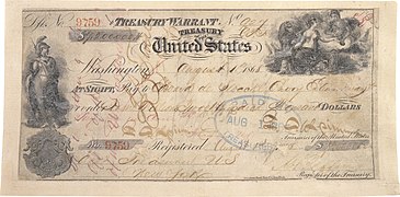
 Introduction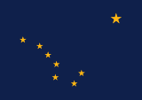   Alaska ( /əˈlæskə/ ⓘ ə-LASS-kə) is a non-contiguous U.S. state on the northwest extremity of North America. It borders the Canadian province of British Columbia and the Yukon territory to the east; it shares a western maritime border in the Bering Strait with Russia's Chukotka Autonomous Okrug. The Chukchi and Beaufort Seas of the Arctic Ocean lie to the north and the Pacific Ocean lies to the south. Technically a semi-exclave of the U.S., it is the largest exclave in the world. Alaska is the largest U.S. state by area, comprising more total area than the next three largest states of Texas, California and Montana combined, and is the seventh-largest subnational division in the world. It is the third-least populous and most sparsely populated U.S. state, but is, with a population of 736,081 as of 2020, the continent's most populous territory located mostly north of the 60th parallel, with more than quadruple the combined populations of Northern Canada and Greenland. The state contains the second-largest and largest cities in the United States by area: the state capital of Juneau, and its former capital, Sitka, respectively. The state's most populous city is Anchorage and approximately half of Alaska's residents live within its metropolitan area. Indigenous people have lived in Alaska for thousands of years, and it is widely believed that the region served as the entry point for the initial settlement of North America by way of the Bering land bridge. The Russian Empire was the first to actively colonize the area beginning in the 18th century, eventually establishing Russian America, which spanned most of the current state, and promoted and maintained a native Alaskan Creole population. The expense and logistical difficulty of maintaining this distant possession prompted its sale to the U.S. in 1867 for US$7.2 million (equivalent to $157 million in 2023). The area went through several administrative changes before becoming organized as a territory on May 11, 1912. It was admitted as the 49th state of the U.S. on January 3, 1959. Abundant natural resources have enabled Alaska—with one of the smallest state economies—to have one of the highest per capita incomes, with commercial fishing, and the extraction of natural gas and oil, dominating Alaska's economy. U.S. Armed Forces bases and tourism also contribute to the economy; more than half the state is federally-owned land containing national forests, national parks, and wildlife refuges. It is among the most irreligious states, one of the first to legalize recreational marijuana, and is known for its libertarian-leaning political culture, generally supporting the Republican Party in national elections. The Indigenous population of Alaska is proportionally the second highest of any U.S. state, at over 15 percent, after only Hawaii. ( Full article...) Entries here consist of
Good and
Featured articles, which meet a core set of high editorial standards.
The Hope Highway, also known as the Hope Road Turnoff, is a Forest Highway located in the Kenai Peninsula Borough, in the U.S. state of Alaska. The highway connects the city of Hope to the Seward Highway, and travels through 17 miles (27 km) of the Chugach National Forest. The road passes the ghost town of Sunrise City and several smaller settlements, remnants of the gold rush that occurred in that area. The highway was created circa 1928 and was designated as Forest Highway 14 by the Federal Highway Administration. ( Full article...) TopicsCategoriesSelected article -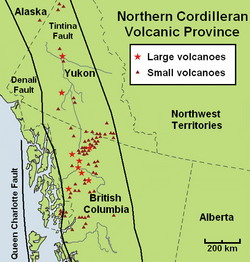 The volcanic history of the Northern Cordilleran Volcanic Province presents a record of volcanic activity in northwestern British Columbia, central Yukon and the U.S. state of easternmost Alaska. The volcanic activity lies in the northern part of the Western Cordillera of the Pacific Northwest region of North America. Extensional cracking of the North American Plate in this part of North America has existed for millions of years. Continuation of this continental rifting has fed scores of volcanoes throughout the Northern Cordilleran Volcanic Province over at least the past 20 million years (see Geology of the Pacific Northwest) and occasionally continued into geologically recent times. Eruptive activity in the Northern Cordilleran Volcanic Province throughout its 20 million year history has been mainly the production of alkaline lavas, including alkaline basalts. A range of alkaline rock types not commonly found in the Western Cordillera are regionally widespread in the Northern Cordilleran Volcanic Province. These include nephelinite, basanite and peralkaline phonolite, trachyte and comendite lavas. The trachyte and comendite lavas are understood to have been created by fractionation of mainly alkali basalt magma in crustal reservoirs. An area of continental rifting, such as the Northern Cordilleran Volcanic Province, would aid the formation of high-level reservoirs of capable size and thermal activity to maintain long-lived fractionation. In the past 15 million years, at least four large volcanoes have formed their way through dense igneous and metamorphic composed bedrock of this part of North America. This includes Hoodoo Mountain, the Mount Edziza volcanic complex, Level Mountain and Heart Peaks, which are primarily located in northwestern British Columbia. Most notable of these is the 7.5 million year old Mount Edziza volcanic complex, which has had more than 20 eruptions in the past 10,000 years. The only activity present in the Northern Cordilleran Volcanic Province has been occasional earthquakes and constant boiling of hot springs. However, a high potential exists for renewed eruptive activity that could threaten life and property in the volcanic zone. ( Full article...)Selected picture - Alaska wild berries from the Innoko National Wildlife Refuge. Photo credit: US Fish and Wildlife Service General imagesThe following are images from various Alaska-related articles on Wikipedia.
Recognized content
Featured articlesGood articles
Featured pictures
Former featured pictures
Related Portals
Related WikiProjectsState facts
State symbols:
Tasks
Associated WikimediaThe following Wikimedia Foundation sister projects provide more on this subject:
Discover Wikipedia using
portals |


