From Wikipedia, the free encyclopedia
This article needs additional citations for
verification. Please help
improve this article by
adding citations to reliable sources. Unsourced material may be challenged and removed. Find sources: "Pillar Provincial Park" – news · newspapers · books · scholar · JSTOR (December 2009) ( Learn how and when to remove this template message) |
Provincial park in British Columbia, Canada
| Pillar Provincial Park | |
|---|---|
IUCN category II (
national park) | |
 Panoramic view | |
| Location | British Columbia, Canada |
| Nearest city | Salmon Arm |
| Coordinates | 50°35′21″N 119°37′56″W / 50.58917°N 119.63222°W / 50.58917; -119.63222 |
| Area | 0.02 km2 (0.0077 sq mi) |
| Established | March 17, 2004 (2004-03-17) |
| Governing body | BC Parks |
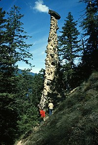
Pillar Provincial Park is a provincial park in British Columbia, Canada. It is located 11 km (6.8 mi) north of Highway 97 at Falkland. The park area is 2.34 hectares and protects a stone pillar (sometimes called a hoodoo) on the hillside above Pillar Lake.
External links
50°35′22″N 119°37′57″W / 50.5894°N 119.6325°W / 50.5894; -119.6325
|
| This British Columbia protected areas related article is a stub. You can help Wikipedia by expanding it. |
Retrieved from "
https://en.wikipedia.org/?title=Pillar_Provincial_Park&oldid=1119753160"
