(Redirected from
Maquinna Marine Provincial Park)
| Maquinna Marine Provincial Park and Protected Area | |
|---|---|
 Maquinna Marine Provincial Park and Protected Area | |
| Location | Clayoquot Sound, British Columbia, Canada |
| Coordinates | 49°24′00″N 126°20′30″W / 49.40000°N 126.34167°W |
| Area | 2,667 ha (10.30 sq mi) |
| Established | January 7, 1955 |
| Governing body | BC Parks |
| Website | BC Parks Maquinna |
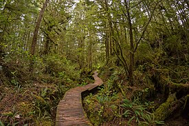
Maquinna Marine Provincial Park and Protected Area is a provincial park in British Columbia, Canada, located northwest of Tofino in the Clayoquot Sound region of the West Coast of Vancouver Island, protecting Ramsay Hot Springs, which is the name-source of the cove, settlement and former post office of Hot Springs Cove.
See also
References
- ^ "Protected Planet | Maquinna Marine Park". Protected Planet. Retrieved 2020-10-22.
External links
-
 Media related to
Maquinna Marine Provincial Park at Wikimedia Commons
