| Lynn Camp Creek Wilderness Study Area | |
|---|---|
IUCN category Ib (
wilderness area) | |
 | |
| Location | Bland County Virginia, United States |
| Nearest city | Bland, Virginia |
| Coordinates | 37°01′14″N 81°22′29″W / 37.02058°N 81.37478°W |
| Area | 3,226 acres (1,306 ha) |
| Established | 2009 |
| Administrator | U.S. Forest Service |
The Lynn Camp Creek Wilderness Study Area, a 3226-acre site in the Eastern Divide Ranger District of the George Washington and Jefferson National Forests, was designated a wilderness study area by the Omnibus Public Lands Act of 2009. [1]
Lying in a deep valley between Brushy Mountain and Lynn Camp Mountain, the area is remote with a section of the Appalachian Trail that is rarely visited. [1]
The area is part of the Garden Mountain Cluster.
Location and access
The area is located about 2 miles northwest of Ceres in Bland County, Virginia. There are two trails for access, the Appalachian Trail and the Lynn Camp Creek Trail.
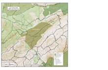
The Lynn Camp Creek Trail, Forest Trail 6511, is two miles long with trailhead on Forest Service Road 632, accessed by taking VA 625 from Ceres. [2] [3]
A 6.3 mile section of the Appalachian Trail passes through the area, with trailheads on the north at VA 622 and to the south on VA 42. [1] [4]
Natural history
Valleys along streams in the study area contain thick groves of rhododendron with pines and hemlocks. Valley bottoms contain hardwoods, tulip tree, basswood, white ash, red maple, northern red oak, white oak, and cucumber tree while dry ridges are dominated by chestnut oak and scarlet oak. There are also stands of old-growth trees. [5]
Lick Creek contains one of the three populations of the Tennessee Dace, listed as endangered in Virginia. [5]
Lick Creek Natural Area, an 860-acre area created in 1961, borders the wilderness study area on Lynn Camp Creek Mountain. [1]
Topography
Three ridges surround the valleys of Lynn Camp Creek and Lick Creek with elevations ranging from about 2300 feet in the valley bottoms to about 3000 feet on the ridges. [5] [4]
Management
Until Congress makes a decision as to its permanent status, the area is managed by the Forest Service under the same regulations as a Wilderness Area. [1]
There are some regulations to maintain the integrity of the area as a wilderness. For example, motorized equipment, motor vehicles and mountain bikes are prohibited, group size is limited to ten people, and limits are placed on camping. [6]
See also
References
- ^ a b c d e Bamford, Sherman (October 2014). 18 Wonders of Virginia. Richmond, Virginia: Sierra Club Virginia Chapter. pp. 47–49. ISBN 978-0-926487-79-6.
- ^ de Hart, Allen (2003). The Trails of Virginia, Hiking the Old Dominion. Chapel Hill: The University of North Carolina Press. p. 154. ISBN 0-8078-5471-9.
- ^ National Geographic Store: 787 Blacksburg/New River Valley - National Geographic Store Archived 2017-04-24 at the Wayback Machine, accessdate: May 7, 2017
- ^ a b Appalachian Trail Guide, Southwest Virginia (6th ed.). Harpersville, West Virginia: Appalachian Trail Conference. 2015. pp. 75–79. ISBN 978-1-889386-93-5.
- ^ a b c lynncamp.pdf: Lynn Camp Creek '05.qxd - lynncamp.pdf, accessdate: May 7, 2017
- ^ Rules and Regulations: Wilderness.net - Wilderness Rules and Regulations, accessdate: May 7, 2017