| Angels Gate | |
|---|---|
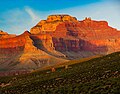
 Angels Gate illuminated, from Shoshone Point | |
| Highest point | |
| Elevation | 6,761 ft (2,061 m) [1] |
| Prominence | 1,361 ft (415 m) [1] |
| Parent peak | Wotans Throne (7,721 ft) [1] |
| Isolation | 1.53 mi (2.46 km) [1] |
| Coordinates | 36°05′38″N 111°59′24″W / 36.0938645°N 111.9900718°W [2] |
| Geography | |
 Angels Gate Location in Arizona  Angels Gate Angels Gate (the United States) | |
| Location |
Grand Canyon National Park Coconino County, Arizona, US |
| Parent range |
Kaibab Plateau
[1] Colorado Plateau |
| Topo map | USGS Cape Royal |
| Geology | |
| Type of rock | sandstone, siltstone, mudstone |
| Climbing | |
| First ascent | April 1972 |
| Easiest route | class 5.8 climbing [3] |
Angels Gate is a 6,761-foot (2,061 m)-elevation summit located in the Grand Canyon, in Coconino County of Arizona, United States. [2] It is situated seven miles (11 km) due north of the Grandview Point overlook on the canyon's South Rim, three miles (4.8 km) west of Vishnu Temple, and three point five miles (5.6 km) southeast of Zoroaster Temple. Topographic relief is significant as it rises over 4,200 feet (1,300 m) above the Colorado River in three miles. Angels Gate is the place in Paiute mythology where the gods would return to Earth by descending from the shadow world above. [4]
George Wharton James applied the "Angel Gate" name to this geographical feature in his book, In & Around the Grand Canyon, in 1900. This feature's name was officially adopted in 1906 by the U.S. Board on Geographic Names. [2] Angels Gate has four peaks composed of Coconino Sandstone. The main highest summit and three spires are known as "Snoopy and his Doghouse" for a resemblance to Snoopy, and the first ascent was made April 1972 by Chuck Graf and Dave Ganci. [5] [6] According to the Köppen climate classification system, Angels Gate is located in a cold semi-arid climate zone. [7]
Geology
The summit of Angels Gate is composed of remnant, cliff-forming, Permian Coconino Sandstone. [8] The sandstone, which is the third-youngest of the strata in the Grand Canyon, was deposited 265 million years ago as sand dunes. Below the Coconino Sandstone is slope-forming, Permian Hermit Formation, which in turn overlays the Pennsylvanian-Permian Supai Group. Further down are strata of Mississippian Redwall Limestone, Cambrian Tonto Group, and finally Proterozoic Unkar Group at creek level and Granite Gorge. [9] Precipitation runoff from Angels Gate drains south to the Colorado River.
Gallery
-
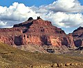
 Northwest aspect
 -
 Angels Gate, with Deva Temple behind
 -
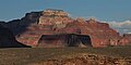
 South aspect
 -
 From the southeast
 -
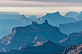
 Wotans Throne behind Angels Gate
 -
 Sunset from Desert View, Angels Gate (lower left of center)
 -
 Wotans Throne (left) and Angels Gate from west on Tonto Trail
 -
 Angels Gate from Desert View
 -
 Angels Gate from south, circa 1901


Hawkins Butte

Hawkins Butte is a 5,340-foot (1,630 m)-elevation butte attached at the southwest end of Angels Gate. [10] It was officially named in 1932 after William "Billy" Robert Hawkins, the hunter and cook for John Wesley Powell's 1869 expedition down the Colorado River through the Grand Canyon. [11] It is primarily composed of exposed cliffs of Redwall Limestone overlaying Tonto Group.
See also
References
- ^ a b c d e "Angels Gate, Arizona". Peakbagger.com. Retrieved 2020-12-24.
- ^ a b c "Angels Gate". Geographic Names Information System. United States Geological Survey, United States Department of the Interior. Retrieved 2020-12-24.
- ^ "Angels Gate – 6,761' AZ". Lists of John. Retrieved December 24, 2020.
- ^ George Wharton James, In & Around the Grand Canyon, 1900, Little, Brown, and Company, page 90.
- ^ National Park Service
- ^ John Annerino, Adventuring in Arizona, 1991, Sierra Club Books, ISBN 9780871566812 page 327.
- ^ Peel, M. C.; Finlayson, B. L.; McMahon, T. A. (2007). "Updated world map of the Köppen−Geiger climate classification". Hydrol. Earth Syst. Sci. 11. ISSN 1027-5606.
- ^ N.H. Darton, Story of the Grand Canyon of Arizona, 1917, page 56.
- ^ N.H. Darton, Story of the Grand Canyon of Arizona, 1917.
- ^ "Hawkins Butte – 5,340' AZ". Lists of John. Retrieved 2021-02-03.
- ^ "Hawkins Butte". Geographic Names Information System. United States Geological Survey, United States Department of the Interior. Retrieved 2021-02-03.
External links
- Weather forecast: National Weather Service
- Angels Gate rock climbing: Mountainproject.com
- Photo of Billy Hawkins: NY Public Library
- Billy Hawkins' account of expedition: Rockhounds.com
- Angels Gate photo by Harvey Butchart