| This page is an archive. Do not edit the contents of this page. Please direct any additional comments to the current main page. |

Locator maps
Hey, I created a location map for Doha, file:Qatar Doha location map.svg. can somone create locator maps for the Neighborhoods of Doha out of it?-- Mikey641 ( talk) 21:04, 20 September 2016 (UTC)
Cyprus Districts
Hello. I need maps of w:Districts of Cyprus. There are 5 districts. But I need 10 maps, 2 for each districts, 1 before 1974 and 1 after. You can use File:Cyprus adm location map.svg and File:Cyprus adm (1960–1974) location map.svg. There are some maps like File:Larnaca in Cyprus.svg but it has problems: 1) I need only the district to be showed, not all the map of Cyprus, 2) I need the occupied are to be showed clearly (like in File:Cyprus adm location map.svg and 3) to be in white color, not in red. Xaris333 ( talk) 08:24, 12 October 2016 (UTC)
-
 Mataram's expansions
- Article(s)
- Mataram conquest of Surabaya
- Request
- Need a better map for Mataram conquest of Surabaya. The existing map (see above) already has the details, but it covers all of Java and all Mataram's expansions under Sultan Agung (the interest of the article is only the eastward ones), so the map appear too "skinny" (horizontally) and need zooming in order to see it clearer. Naively cropping it doesn't work because it will result in the legend being cut off. Would it be possible to have a map that's a part of the existing map? Ideally, it would cover only Mataram and the parts of Java to its east, as well as the eastward arrows (attacks) and battles. If possible it can also include an westward counteroffensive by Surabaya, which went by route of Lasem -> Pati along the coast -> southward toward Pajang where a battle happened in January 1616. This counteroffensive was mentioned & sourced in the article, and the route source is the Saiful Ali 1994 p. 51. The map doesn't need to cover Bali, which aren't involved in this campaign, but the northward overseas expedition to Sukadana is part of the campaign, so it should be in.-- HaEr48 ( talk) 07:19, 14 November 2016 (UTC)
- Graphist opinion(s)
Sasanian Empire Map
-
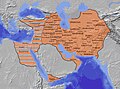 Original map.
 -
 My 2.0 version of the map


- Article(s)
- Sassanian_Empire
- Request
- New Sasanian Empire map.
- Please make a new map of the Sasanian Empire that is in the model of both my original and 2.0 map (both of which show the Sasanian Empire at it's greatest extent in the year 621 A.D.) Have the territories of the Byzantine Empire occupied by the Sasanian Empire in shaded like the two examples above. If you can please make the quality of the map better than mine as well, that would be great. Since this one isn't too nice looking.
- -Some of the western part should look like this [1]. Remember to put Arbayistan above the Garamig ud Nodardashiragan province. Atropatene ---> Adurbadagan. Gorgan ---> Gurgan. Harey ---> Harev. Khuzistan ---> Khuzestan. Sogdiana ---> Sogdia. Asuristan ---> Asoristan. Maishan ---> Meshan. Makran --> Makuran. Paratan --> Paradan. Goyman and Adiabene should be removed. Balasagan needs to be added.
- -The name of the cities needs change as well: Ecbatana --> Hamadan. Merv ---> Marv. Estakhr --> Istakhr. Zarang ---> Zrang.
I had originally been working to make a 3.0 map, but I do not have the time to do it anymore. So I wish the map workshop could make a map that is better than the ones that I made. I am the original creator of these two maps, both of which have been on the infobox of the Sasanian Empire article. There had been a consensus long ago to make a map and I was the one to take the reins of that job. Now that I've been more busy than ever in my everyday livelyhood, I feel that I haven't a choice but to leave this in the hands of the graphists of the map workshop. If you all can create a new map of the Sasanian Empire, that would be excellent.
Regards,
from Kirby… -- Kirby ( talk) 01:46, 20 November 2016 (UTC)
- Graphist opinion(s)
Map for article about Æthelflæd, Lady of the Mercians
-
 Map for article about Æthelred, Lord of the Mercians
 -
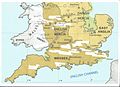 Map amended for article about his wife


- Article(s)
- Æthelflæd
- Request
- User:Philg88 kindly created a map for the article about Æthelred, Lord of the Mercians. (I have asked above for amendments as I have noticed a few typos which I missed.) I have now got the article about his wife, Æthelflæd, daughter of Alfred the Great and the most important female military leader in Anglo-Saxon England, ready for FAC. I should be grateful if anyone can assist with a map of places mentioned in the article. Dudley Miles ( talk) 13:42, 25 November 2016 (UTC)
- Graphist opinion(s)
Tampon tax map
- Article(s)
- Tampon tax#United_States
- Request
- A map of the United States showing which states either exempt or do not tax for tampons. Example here. The use of pink/purple as feminine colors is kind of tired, so perhaps something more creative? (Please {{ ping}} me when responding.) czar 17:21, 25 December 2016 (UTC)
- Graphist opinion(s)

- @
Czar:
 Done. How's this? Rather than risk being creative, I used our standard palette. –
Joe (
talk) 18:04, 25 December 2016 (UTC)
Done. How's this? Rather than risk being creative, I used our standard palette. –
Joe (
talk) 18:04, 25 December 2016 (UTC)
- Thanks, @
Joe Roe! I fear that red might not be great optics for the "tampon tax", but if this is the standard palette, it could do. Appreciate your help! Is there any easy tutorial on how to maintain the map? Is it as easy as GIMP + paint bucket to change states as they flip?
czar 18:40, 25 December 2016 (UTC)
- Czar: this is a well-constructed SVG file, so updating it is easy. If you download it and look at it in a text editor, you will find lines like
- Thanks, @
Joe Roe! I fear that red might not be great optics for the "tampon tax", but if this is the standard palette, it could do. Appreciate your help! Is there any easy tutorial on how to maintain the map? Is it as easy as GIMP + paint bucket to change states as they flip?
czar 18:40, 25 December 2016 (UTC)
<path id="CT" fill="#E41A1C" d=etc.
- This tells you that color for state CT (Connecticut, I assume) is E41A1C, which is red; the rest of the line specifies the outline of the state, and you can ignore it. If Connecticut changes its law to be like that of Massachusetts, you look for the line for "MA", find 377EB8, and copy that in place of the E41A1C.
Maproom (
talk) 20:12, 25 December 2016 (UTC)
- Nice! Thank you both.
czar 00:12, 26 December 2016 (UTC)
- Thanks
Maproom.
Czar, feel free to ask me to update it if you don't fancy it. I'd suggest uploading a new file if you do, the old versions might potentially be useful for showing the progress of its repeal. I did notice that the map I was basing it on was from June 2015, so I wonder if it might already need updating? –
Joe (
talk) 00:22, 26 December 2016 (UTC)
- Yep, the section shows a few state changes, if you'll take a look, but I would still need to follow-up on how they went (e.g., California made tampons tax exempt but the bill was vetoed by the governor) czar 00:24, 26 December 2016 (UTC)
- Thanks
Maproom.
Czar, feel free to ask me to update it if you don't fancy it. I'd suggest uploading a new file if you do, the old versions might potentially be useful for showing the progress of its repeal. I did notice that the map I was basing it on was from June 2015, so I wonder if it might already need updating? –
Joe (
talk) 00:22, 26 December 2016 (UTC)
- Nice! Thank you both.
czar 00:12, 26 December 2016 (UTC)
- This tells you that color for state CT (Connecticut, I assume) is E41A1C, which is red; the rest of the line specifies the outline of the state, and you can ignore it. If Connecticut changes its law to be like that of Massachusetts, you look for the line for "MA", find 377EB8, and copy that in place of the E41A1C.
Maproom (
talk) 20:12, 25 December 2016 (UTC)
New Mexico
- Article(s)
- not sure
- Request
- The map is out of date. Not all of New Mexico has this area code anymore. You can see this at /info/en/?search=File:Area_codes_NM.svg. Could you add area code 575 to this map? 208.95.51.72 ( talk) 18:07, 13 January 2017 (UTC)
- Graphist opinion(s)
- Is there any reason why you can't use use the more up to date
File:Area codes NM.svg? (Bitmap images are often superseded by more flexible .svg versions). –
Joe (
talk) 18:26, 13 January 2017 (UTC)
- If we don't need it, should it just be requested for deletion? 208.95.51.72 ( talk) 20:22, 13 January 2017 (UTC)
Israel Railways map needs updating
-
 Current map of Israel railways

It would be nice if we could have new Israel Railways map set up by the 16th of the month, when a new line opens up - the line to Bet She'an on this official map (station names are both in English and in Hebrew on the map, although city names may not match our spelling). עוד מישהו Od Mishehu 03:14, 10 October 2016 (UTC)
-
עוד מישהו, I asked the file creator to update it, but he's on vacation, so when he returns he will update it.--
Mikey641 (
talk) 11:02, 16 October 2016 (UTC)
- @
Sameboat: Please also note the Netanya Sapir station, south of (and on the same lines as) the Netanya station.
עוד מישהו
Od Mishehu 14:27, 10 November 2016 (UTC)
- @
Od Mishehu and
Mikey641: Done, but it still lacks the Hebrew text for "Night line" so please provide a brief Hebrew translation for me to add. --
Sameboat - 同舟 (
talk ·
contri.) 12:56, 11 November 2016 (UTC)
- @
Sameboat:, קו לילה--
Mikey641 (
talk) 14:00, 11 November 2016 (UTC)
- @ Mikey641 and Od Mishehu: Done. As you can see I've also added Haifa Airport and its official connection with railway stations. I can remove them if you don't think they are worth mentioning in the railway map. -- Sameboat - 同舟 ( talk · contri.) 13:23, 12 November 2016 (UTC)
- @
Mikey641,
Od Mishehu,
IKhitron,
Hummingbird, and
רונאלדיניו המלך: I was too careless that I missed the Grey Line (Acre to Haifa – Hof HaCarmel) but it is now added to my map. I don't know why the
Hebrew Wikipedia article of Israel Railways still uses the 2014 official passenger service map, but now my latest version should qualify the replacement. So maybe you guys can do a final proofread. --
Sameboat - 同舟 (
talk ·
contri.) 11:47, 16 November 2016 (UTC)
- @
Sameboat: What do you mean in 2014 map?
IKhitron (
talk) 11:51, 16 November 2016 (UTC)
- @
IKhitron: Forget it. I mistook some information. But
he:file:IsraelTrainPassenger.svg by
he:use:רונאלדיניו is strange that it uses colors for some lines which are different than the official version. The Cyan Line in this version begins at Tel Aviv – Savidor Center instead of Herzliya and Ben Gurion Airport station has different Hebrew text which baffle me. And last maybe not least, it lacks Netanya – Sapir station. --
Sameboat - 同舟 (
talk ·
contri.) 12:08, 16 November 2016 (UTC)
- The Hebrew name at the Ben Gurion station is an abbreviation frequently used in Israel to refer to the airport, so an Israeli would understand what that means. And the north end of the cyan line is probably outdates information, not incorrect.
עוד מישהו
Od Mishehu 14:55, 16 November 2016 (UTC)
- @
Od Mishehu: So I need to change the north terminus of the cyan line in my map too, right? --
Sameboat - 同舟 (
talk ·
contri.) 15:15, 16 November 2016 (UTC)
- No, ypu have it right; the Hebrew file youlinked to has it outdated.
עוד מישהו
Od Mishehu 19:17, 16 November 2016 (UTC)
- Ok, I`ll try update this tomorrow. Tal (
Ronaldinho The king) 23:22, 18 November 2016 (UTC)
- @ Mikey641, Od Mishehu, IKhitron, Hummingbird, and רונאלדיניו המלך: Ok, I have extended Herzliya, and moved Acer-Hof Carmel, anything more needs update?. Tal ( Ronaldinho The king) 15:50, 21 November 2016 (UTC)
- Ok, I`ll try update this tomorrow. Tal (
Ronaldinho The king) 23:22, 18 November 2016 (UTC)
- No, ypu have it right; the Hebrew file youlinked to has it outdated.
עוד מישהו
Od Mishehu 19:17, 16 November 2016 (UTC)
- @
Od Mishehu: So I need to change the north terminus of the cyan line in my map too, right? --
Sameboat - 同舟 (
talk ·
contri.) 15:15, 16 November 2016 (UTC)
- The Hebrew name at the Ben Gurion station is an abbreviation frequently used in Israel to refer to the airport, so an Israeli would understand what that means. And the north end of the cyan line is probably outdates information, not incorrect.
עוד מישהו
Od Mishehu 14:55, 16 November 2016 (UTC)
- @
IKhitron: Forget it. I mistook some information. But
he:file:IsraelTrainPassenger.svg by
he:use:רונאלדיניו is strange that it uses colors for some lines which are different than the official version. The Cyan Line in this version begins at Tel Aviv – Savidor Center instead of Herzliya and Ben Gurion Airport station has different Hebrew text which baffle me. And last maybe not least, it lacks Netanya – Sapir station. --
Sameboat - 同舟 (
talk ·
contri.) 12:08, 16 November 2016 (UTC)
- @
Sameboat: What do you mean in 2014 map?
IKhitron (
talk) 11:51, 16 November 2016 (UTC)
- @
Sameboat:, קו לילה--
Mikey641 (
talk) 14:00, 11 November 2016 (UTC)
- @
Od Mishehu and
Mikey641:
- @
Sameboat: Please also note the Netanya Sapir station, south of (and on the same lines as) the Netanya station.
עוד מישהו
Od Mishehu 14:27, 10 November 2016 (UTC)
Red wolf subspecies range map
.svg)
- Article(s)
- Red wolf
- Request
- A map of the former distribution of red wolf subspecies, based on the map present on page 89 of this paper here: http://www.biodiversitylibrary.org/item/22683#page/101/mode/1up -- Mariomassone ( talk) 09:59, 17 December 2016 (UTC)
- Graphist opinion(s)
- @
Mariomassone: Maybe use a more up to date source?
GBIF has many more occurences, for example. Also, did you want to include
Canis edwardii (the triangles on the 1979 map)?
Joe Roe (
talk) 12:14, 17 December 2016 (UTC)
- The map shows the historical distribution of the subspecies, two of which are now extinct in any case. Sorry for not specifying that the map is meant to represent past distribution. Canis edwardii is unecessary, as it's not considered a race of red wolf. Thank you for your speedy reply!
Mariomassone (
talk) 12:41, 17 December 2016 (UTC)
- Ditto! GBIF includes fossil and historical/archaeological occurrences, if you filter the map on the page I linked to only "Pre 1900" you can see them. My concern is just that 1979 is quite a long time ago as far as zooarchaeology goes and there are likely to have been many more sites with C. rufus discovered since. For example, there seem to be a couple in Baja California, whereas Nowak only has the range going as far west as Arkansas. Joe Roe ( talk) 12:50, 17 December 2016 (UTC)
- The map shows the historical distribution of the subspecies, two of which are now extinct in any case. Sorry for not specifying that the map is meant to represent past distribution. Canis edwardii is unecessary, as it's not considered a race of red wolf. Thank you for your speedy reply!
Mariomassone (
talk) 12:41, 17 December 2016 (UTC)
Bucharest metro scheme (SVG)
-
 Location map used on en.wp
 -
 Location map used on ro.wp
 -
 Map showing the real positions of current and construction stations
 -
 Proposed SVG map


- Article(s)
- Bucharest Metro
- Request
- We are in dire need of a high-quality SVG map of the Bucharest metro that can be easily updated by amateurs when new stations open (likely several times in the next year). The current best images are the ones above:
- The map on en.wp is well balanced and easy to read, but it is png and dated: it presents some segments that do not even exists (Râul Doamnei - Ghencea on M5), other segments are in the wrong place (Eroilor - Piața Romană on M5 should be Eroilor - Universitate and is not yet in construction) and the station names on the M6 line are simply dated and misspelled; it also lacks a legend
- The map on ro.wp is also a png and seems crowded, has the wrong color on M5 and no station names on M6 (probably because it's crowded).
- The third image is not really a scheme, but a location map, so it is not easily readable and low resolutions; it also have some wrong station names on M5.
- What we need (in order of importance):
- SVG map
- Respects the station names, as they are mentioned in the templates at the bottom of the ro:Metroul din București article.
- Respects the line colors, as they are presented in the official map. The HTML colors can be found in ro:Format:Linie Metrorex with invocations such as {{Linie Metrorex|M1}} (where M1-M7 are the lines)
- The general structure should be easily visible at infobox resolution. Resemblance with the official map is optional.
- Can be used as imagemap like on ro:Format:Harta metrou (Station names should be delimited? Any ideas on how to "guide" the user are welcomed)
- Stations can be changed from "in construction" to "open" individually, by deleting a layer from the svg. It is important that each station be separate because certain segments can be postponed with short notice from the powers to be and then changing the svg becomes more difficult.
- If possible, leaving some space for future lines (M2, M3, M4 extensions + M7, M8) would help, but is not compulsory. These lines should not be drawn, as their paths are not yet finalized. The full map of planned lines can be found at [2].
- If not all requirements can be achieved on the same map, perhaps we can get more then one image? Thank you.-- Strainu ( talk) 00:43, 27 December 2016 (UTC)
- Graphist opinion(s)
![]() Request taken by
Mliu92 (
talk) 19:34, 5 January 2017 (UTC).
Request taken by
Mliu92 (
talk) 19:34, 5 January 2017 (UTC).
@ Strainu, please let me know what you think. I took the station names and rough routing from the official map published by Metrorex, using some of the extra bends in the first map in the gallery to gain a little more space between stations. I can't comment on how easy it will be to add future lines, but the drawing size may need to be expanded when new lines are added. The lines currently planned (parts of M4 and M6) are illustrated with all the listed stations. The map is drawn (as closely as possible) using a 50px by 50px square grid to facilitate the routing. I used the hex colors for lines from the linked ro:Format:Linie Metrorex article.
To turn stations from "under construction" to "complete" is a simple matter of editing the border color from #888 to #000. The lines that are "under construction" are illustrated by adding a second white dashed line on top of the solid-color line. Therefore a line can be "completed" by editing the second line (either deleting or moving nodes as appropriate). I uploaded the file as an "optimized SVG" which means the layers got flattened, but I can also upload the Inkscape SVG if needed (Inkscape tends to make a fairly bloated SVG).
Cheers, Mliu92 ( talk) 19:34, 5 January 2017 (UTC)
- Hi Mliu, thank you for the work. I particularly like the legend, it's very clear which lines are done and which ones are only partially finished and also the look of Gara de Nord.
- There are a few small issues with the current proposal:
- you used the old, incorrect Romanian diacritics. This is a long story, the short version is that you should use the following characters: șȘțȚ.
- The station "Depou Străulești" will not be opened to the public, so it should not appear on the map (just like "Depoul Preciziei" does not appear). I think this should give you the possibility to bring M4 closer to M1 and thus more space for M6.
- The station names on M5 have changed. The names the we can currently source are at ro:Format:Metrou_M5. The layout of the line looks great, though!
- If you could also upload the Inkscape version of the SVG, it would be great - it would make it easier for me to edit the map later on. Thank you again.-- Strainu ( talk) 20:06, 5 January 2017 (UTC)
- One more thing, after reading the file description on commons: M4 (between Parc Bazilescu and Străulești) is under construction, not in planning. There is another part of M4 in planning, but that one should not appear on the map yet.--
Strainu (
talk) 20:13, 5 January 2017 (UTC)
- @ Strainu, thanks for the corrections and suggestions; I have re-uploaded as an Inkscape file with layers and names taken from the ro:Format:Metrou_M1, M2, M3, M4, M5, M6 articles. I apologize for any inadvertent offense from the use of deprecated diacritics as I was working visually from the linked Metrorex PDF, which wasn't very high-resolution. M4 wass slightly rerouted to gain a little more space for M6 .
- Cheers, Mliu92 ( talk) 21:56, 5 January 2017 (UTC)
Remove a no-longer-extant city
-
 Locator map of the US state of Virginia

- Article(s)
- More than four thousand articles; [3] displays the first 4000 and produces a link to the next group of 4,000, although [4] demonstrates that the total is under 5,000.
- Request
- Please remove the city of Bedford from the map, since it's no longer a city and doesn't warrant an appearance here. File:VAMap-doton-Bedford.png gives you Bedford's location. Also, please see the "Relabelling in an SVG" section of Wikipedia:Graphics Lab/Map workshop/Archive/2016, which resulted in the same change being made to a different Virginia map. Nyttend ( talk) 05:42, 28 December 2016 (UTC)
- Graphist opinion(s)
Map for Operation Trident and Operation Python
-
Description of first image
- Article(s)
- Operation Trident (1971)
- Operation Python
- Request
- A map showing Mumbai, Okha, India and Karachi. A continuous curve between Mumbai and Okha, and a dotted curve between Okha and Karachi -- Regards, Krishna Chaitanya Velaga ( talk • mail) 09:00, 1 January 2017 (UTC)
- Graphist opinion(s)
Australian aboriginal languages

- Article(s)
- Australian aboriginal languages
- Request
- please add Victoria borders… -- Kintetsubuffalo ( talk) 12:55, 1 January 2017 (UTC)
- Graphist opinion(s)
Map of the Mithila/Tirhut region
-
 Description of first image

- Article(s)
- Maithil, Mithila (ancient)
- [[]]
- Request
- Damien2016 ( talk) 13:13, 4 January 2017 (UTC) Looking for a map of the Mithila region and Maithili speaking areas. The current map on the Mithila, India article is more of an administrative region and doesn't reflect the historical region. Please recreate the posted map to include bordering areas in Nepal and remove some of the areas not within the historical borders.
The most accurate depiction I can find is here: https://books.google.co.uk/books?id=jWIPDQAAQBAJ&pg=PT215&dq=oinwar+tirhut&hl=en&sa=X&redir_esc=y#v=onepage&q=oinwar%20tirhut&f=false
Thank you for your help! Damien2016 ( talk) 13:13, 4 January 2017 (UTC)
- Graphist opinion(s)
Corrections to map of Anglo-Saxon England
-
Map of Anglo-Saxon England c.910
- Article(s)
- Æthelred, Lord of the Mercians
- Request
- User:philg88 kindly created this map for Æthelred, Lord of the Mercians, but I have noticed a few typos which I did not pick up at the time. 1. Battle of Edington in the south should be dated 878, not 825. 2. Battle of Tettenhall in the middle should be dated 910, not 893. 3. Much Wenlove, near the Welsh border, should be Much Wenlock. Thanks if anyone can help. Dudley Miles ( talk) 13:15, 25 November 2016 (UTC)
- Graphist opinion(s)
- The labels on the original map are paths rather than text which makes this awkward. There's an older version with text labels, so it might be easier to revert to that. Or simply try to match the fonts? What do other graphists think? Joe Roe ( talk) 13:16, 17 December 2016 (UTC)
-
 In progress –
Joe (
talk) 14:29, 12 February 2017 (UTC)
In progress –
Joe (
talk) 14:29, 12 February 2017 (UTC) - @
Dudley Miles: Done. I realised that all the changes you want were present in a previous version (because you'd
pointed them out before), so I've just reverted to that. For some reason
Philg88 undid those changes when he uploaded the most recent version in August 2014 – perhaps he inadvertently used an old file? As far as I can tell all that changed in that version was the addition of duplicate labels for the battles, but could I ask you just double check that everything is correct now, and if so mark this request as {{
resolved}}? –
Joe (
talk) 22:23, 18 February 2017 (UTC)
- That is great Joe. Many thanks for your help. Dudley Miles ( talk) 16:42, 19 February 2017 (UTC)
->
Kalakaua journey round the world
-

-
 Vectorized, added places


- Article(s)
- King Kalākaua's world tour
- Request
- Essentially please recreate this but better (for the lack of a better word). The stops are listed in the article with the sources and if possible, it would be great to get it more detailed especially in his last leg of the journey in the US. This is part of
Wikipedia:Featured article candidates/King Kalākaua's world tour/archive1.--
KAVEBEAR (
talk) 05:50, 8 January 2017 (UTC)
- Comments by
User:Maile66 - I think it misses the return trip to Paris. What do you think about a different base map, maybe one that is not in color? The current one looks good if you click on it and bring up the full size, but it looks so modern for the subject matter. Can we get Graphics Lab to make one on an old-fashioned patina-colored map? Like maps looked in the 19th century?
— Maile (
talk) 12:38, 8 January 2017 (UTC)
- I've made a new version in vector graphics. It's made on the standard Wikipedia map image, I don't think trying to look old-timey is very encyclopaedic..? I've added Tientsin and Penang, and a bigger map of Europe. There is a collection of newspaper articles on his journey if anyone wants to dig for more stops along the way: Hawai'i Digital Newspaper Project -- Srjskam ( talk) 19:22, 24 June 2017 (UTC)
- Comments by
User:Maile66 - I think it misses the return trip to Paris. What do you think about a different base map, maybe one that is not in color? The current one looks good if you click on it and bring up the full size, but it looks so modern for the subject matter. Can we get Graphics Lab to make one on an old-fashioned patina-colored map? Like maps looked in the 19th century?
— Maile (
talk) 12:38, 8 January 2017 (UTC)
- Graphist opinion(s)
Consanguinity and laws
-
Incest laws in the USA
- Article(s)
- Laws regarding incest in the United States
- Request
- Here is an article that details the few states that have contrariety in their laws [5] -- 88.104.34.11 ( talk) 00:35, 9 January 2017 (UTC)
- Graphist opinion(s)
Battle of Raqqa
.svg)
- Article(s)
- Northern Raqqa offensive (November 2016–present)
- Request
- Keep the map up to date. Yug (talk) 10:31, 9 January 2017 (UTC)
- Graphist opinion(s)
![]() Request taken by I'am on it !
Yug
(talk) 10:28, 9 January 2017 (UTC).
Request taken by I'am on it !
Yug
(talk) 10:28, 9 January 2017 (UTC).
- Hello all ! I'am working on this military campaign map. It's my first military map, so I'am open to ideas or your help to make the maps better looking. Feel free to point me out interesting, well done maps you are aware of and/or to edit the map itself. I would be happy to learn your tricks ! Yug (talk) 10:31, 9 January 2017 (UTC)
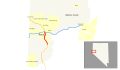
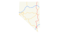
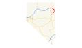
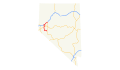
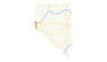
Road maps of Nevada
-
Clark County Route 215 map
-
 Interstate 15 in Nevada map
 -
 Interstate 80 in Nevada map
 -
 Interstate 80 Business (West Wendover, Nevada–Wendover, Utah) map
 -
 Interstate 215 (Nevada) map
 -
 Interstate 515 (Nevada) map
 -
 Intestate 580 (Nevada) map
 -
Las Vegas Beltway map
-
Nevada State Route 430 and U.S. Route 395 Business (Reno)
-
Nevada State Route 529 and U.S. Route 395 Business (Carson City)
-
Nevada State Route 599 and U.S. Route 95 Business (Las Vegas)
-
 Road map of Nevada
 -
 U.S. Route 6 in Nevada
 -
 U.S. Route 50 in Nevada
 -
 U.S. Route 50 Alternate (Nevada)
 -
 U.S. Route 93 in Nevada
 -
 U.S. Route 93 Alternate (Nevada)
 -
 U.S. Route 95 in Nevada
 -
 U.S. Route 95 in Nevada
 -
 U.S. Route 95 Alternate (Schurz–Fernley, Nevada)
 -
U.S. Route 95 Truck (Hawthorne, Nevada)
-
 U.S. Route 395 in Nevada
 -
U.S. Route 395 Alternate (Nevada)
-
 Wendover (Utah/Nevada)
_map.svg)
_map.svg)
_map.svg)
_map.svg)
_map.svg)
_map.svg)

_map.svg)
_map.svg)
_map.svg)
_map.svg)
_map.svg)
_map.png)
_map.svg)
_map.svg)
_map.svg)

- Article(s)
- Interstate 15 in Nevada
- Interstate 80 in Nevada
- Interstate 80 Business (West Wendover, Nevada–Wendover, Utah)
- Interstate 515
- Interstate 580 (Nevada)
- Las Vegas Beltway
- Nevada State Route 430
- Nevada State Route 529
- Nevada State Route 599
- U.S. Route 6 in Nevada
- U.S. Route 50 in Nevada
- U.S. Route 50 Alternate (Nevada)
- U.S. Route 93 in Nevada
- U.S. Route 93 Alternate (Nevada)
- U.S. Route 95 in Nevada
- U.S. Route 95 Alternate (Schurz–Fernley, Nevada)
- U.S. Route 95 Truck (Hawthorne, Nevada)
- U.S. Route 395 in Nevada
- U.S. Route 395 Alternate
- Wendover (Utah/Nevada)
- Request
- Latest update with Interstate 580 (Nevada) extension. -- 2602:302:D1A2:C740:A413:D938:346:65C0 ( talk) 05:30, 15 January 2017 (UTC)
- Graphist opinion(s)
Imperial City, Huế
- Article(s)
- Imperial City, Huế
- Request
- Please create the file out of this map image to the right [6] and include the numbers. Remove all colours however (except for the blue of the water), but mark the inner part in purple as can be seen here [7]. Thank you very much. -- Gryffindor ( talk) 14:17, 17 January 2017 (UTC)
- Graphist opinion(s)

- Article(s)
- Many articles about Cyprus Geography, sports, elections etc
- Request
- Remove the colors of File:Cyprus administrative.jpg or File:Administrative map of Cyprus.jpg. Just to have white color with the borders line. -- Xaris333 ( talk) 15:49, 19 February 2017 (UTC)
- Graphist opinion(s)
Which types of border do you want retained? I see six: black, red, blue, purple, thin discontinuous purple, thinner discontinuous purple. Maproom ( talk) 19:20, 19 February 2017 (UTC)
@ Maproom: All of them if it is possible. If it is not, only the blue (border with the sea) and the purple (district border). Xaris333 ( talk) 20:01, 19 February 2017 (UTC)
-
Xaris333 I've done it.
But the process of getting the upload through the bureaucracy at Commons is beyond me. I've uploaded it to my own website here, and you're welcome to copy it from there and try to upload it to Commons yourself. Meanwhile, I've asked a Commons editor for advice, but I'm not relying on getting a useful answer. Maproom ( talk) 21:12, 19 February 2017 (UTC)And with assistance from a helpful editor on Commons, I've got it uploaded there! It's above. Maproom ( talk) 21:17, 19 February 2017 (UTC)
Many thanks!! Xaris333 ( talk) 21:25, 19 February 2017 (UTC)
Gansu location map

- Article(s)
- Lanzhou Zhangye Jiayuguan (basically any major location in Gansu)
- Request
- Is anyone able to create a location pushpin map for Gansu Province in China? Similar maps exist for other provinces e.g. /info/en/?search=File:China_Sichuan_location_map.svg Thanks in advance! -- NoGhost ( talk) 23:05, 25 February 2017 (UTC)
- Graphist opinion(s)
![]() Request taken by
Auguel (
talk) 00:48, 27 February 2017 (UTC).
Request taken by
Auguel (
talk) 00:48, 27 February 2017 (UTC).
![]() Done
Auguel (
talk) 01:49, 27 February 2017 (UTC)
Done
Auguel (
talk) 01:49, 27 February 2017 (UTC)
-
 Existing map of Arizona 202

- Article(s)
- Arizona State Route 202
- Request
- The final segment of this freeway has been finalized and is under construction. Can this map be updated to show that new section that will connect to the I-10 at 59th ave (probably in a broken-line to show it is currently under construction). The route can be found at [8] -- MB 23:24, 26 February 2017 (UTC)
- Graphist opinion(s)
I would like to help, but I can not open the SVG file in Inkscape. If someone can, please contact me, so we can find out the problem.-- Lommes ( talk) 16:20, 12 April 2017 (UTC)


KAVEBEAR, I have made an overlay of the project plan that is then integrated with the relevant part of the Open Street Map using {{ OSM Location map}}, with a selection of labels added, which you can edit or add to as required. You will need to cut and paste the whole template to add to your page. RobinLeicester ( talk) 00:40, 18 March 2017 (UTC)
- @ RobinLeicester: Wow amazing! There is a missing strip on the right side; it's yellow in the link above and possibly represent a dock on the mainland of the former lake or something. Can you also label the street to the north called Mokuhinia Place? Thanks.
- How do I tweak with the size? And can you possibly screenshot this and upload it as a map to the commons in file form, so it can exist in that more simplify form as well? It will let me use it in tables or gallery for example. Thanks.-- KAVEBEAR ( talk) 00:58, 18 March 2017 (UTC)
-
KAVEBEAR, Overlay updated (I forgot to do the yellow strip), and road name now added. If you adjust the width and height values at the start of the template it will bring in or move out the sides, but will not affect the scale (zoom) of the map. Once you have a dimension that feels right, if you need to save it as a single image, simply right click and 'save image as...'. You can then upload the file to commons. However, at that point it loses the ability for people to edit the content in the future, which is one of the huge benefits of the template approach. Maybe the 'source template' could be added to the article's talk page, so it is still available to adapt.
RobinLeicester (
talk) 22:56, 18 March 2017 (UTC)
- Thank you so much. Yes I like to use it this once I get to expanding the page more. I will definitely keep the source file. But as for a more simplify file on commons I can't upload the file to commons since I am not the creator. You are. I'm fine with it as is. Can you possibly save that image and upload it to the commons as you are the creator? Thank you so much!-- KAVEBEAR ( talk) 08:04, 19 March 2017 (UTC)
-
KAVEBEAR, Overlay updated (I forgot to do the yellow strip), and road name now added. If you adjust the width and height values at the start of the template it will bring in or move out the sides, but will not affect the scale (zoom) of the map. Once you have a dimension that feels right, if you need to save it as a single image, simply right click and 'save image as...'. You can then upload the file to commons. However, at that point it loses the ability for people to edit the content in the future, which is one of the huge benefits of the template approach. Maybe the 'source template' could be added to the article's talk page, so it is still available to adapt.
RobinLeicester (
talk) 22:56, 18 March 2017 (UTC)

- KAVEBEAR, Commons png map is done (right). To my mind, everything in the map has been placed as share-alike material, that anyone can re-post and modify, with suitable attribution. No matter. Best wishes with the article. RobinLeicester ( talk) 23:24, 19 March 2017 (UTC)
- Thank you so much!-- KAVEBEAR ( talk) 02:11, 20 March 2017 (UT->
Request for U.S. map displaying specific cities for article about the Not My Presidents Day protest
- Article(s)
- Not My Presidents Day
- Request
- Long shot here, so I won't hold my breath, but here I posted a request for a map of the U.S. displaying pins where Not My Presidents Day were held. I doubt this exists, but I really wish there were a way to simply take a U.S. map and enter city names to create a map displaying pinpoints for select cities, which could then be used for articles like Not My Presidents Day. I think the Wikipedia article would benefit from a graphic showing participating cities. Is this possible for someone to create, or is there a place where I could create this myself? I'm willing to provide a list of participating cities (I believe there are around 25), if that helps. I'll try to keep an eye on this page, or please "ping" me here or on my talk page for a faster response. Thanks! ---- Another Believer ( Talk) 21:49, 23 March 2017 (UTC)
- Graphist opinion(s)

@ Another Believer: That's what location maps are for. You just have to add cities and increase the width if necessary. NNW ( talk) 19:40, 25 March 2017 (UTC)
- @ NordNordWest: Thanks. I'll see if I can replicate this elsewhere. --- Another Believer ( Talk) 22:50, 25 March 2017 (UTC)
- @ NordNordWest: Can I ask, how do I find the coordinates to enter into the template? For example, I don't see "90.0666" anywhere within the Wikipedia article for New Orleans. I've never really understood how coordinates work on Wikipedia. Any insight would be very helpful. --- Another Believer ( Talk) 23:08, 25 March 2017 (UTC)
- @
Another Believer: You just open the article to the town that you want to add. On the top of the article you can see coordinates. You click onto the coordinates and the GeoHack page opens, e.g.
New Orleans. In the grey box on top you will find the coordinates in different types and you just copy the decimal coordinates. The first number is lat_deg, the second is lon_deg. Don't forget to copy the minus at the lon_deg, otherwise you will have coordinates of the Eastern hemisphere. That's all.
NNW (
talk) 10:42, 26 March 2017 (UTC)
- @ NordNordWest: This is very helpful. Thank you! --- Another Believer ( Talk) 18:01, 26 March 2017 (UTC)
- @
Another Believer: You just open the article to the town that you want to add. On the top of the article you can see coordinates. You click onto the coordinates and the GeoHack page opens, e.g.
New Orleans. In the grey box on top you will find the coordinates in different types and you just copy the decimal coordinates. The first number is lat_deg, the second is lon_deg. Don't forget to copy the minus at the lon_deg, otherwise you will have coordinates of the Eastern hemisphere. That's all.
NNW (
talk) 10:42, 26 March 2017 (UTC)
I am marking this request as resolved since I've been helped. --- Another Believer ( Talk) 18:01, 26 March 2017 (UTC)
Columbia, Maryland


- Article(s)
- Columbia, Maryland
- Request
- png or svg version with "boundaries" spelled correctly, please… -- Kintetsubuffalo ( talk) 10:43, 10 April 2017 (UTC)
- Graphist opinion(s)
-
- Done
Maproom (
talk) 23:17, 12 April 2017 (UTC)
- @
Maproom: ahem, sorry to say, but the quality of the new image is considerably worse than the old one. So bad in fact, I am unsure whether it is still usable. So, I made an SVG version, linked above. Done If someone wants to redraw the village boundaries, be my guest. @
Kintetsubuffalo:, please review.
Lommes (
talk) 10:17, 13 April 2017 (UTC)
- @
Maproom: ahem, sorry to say, but the quality of the new image is considerably worse than the old one. So bad in fact, I am unsure whether it is still usable. So, I made an SVG version, linked above.
- Yeah, .jpgs degrade after editing, which is why I asked for the lossless png or svg version. Thanks both for your hard work!-- Kintetsubuffalo ( talk) 13:37, 13 April 2017 (UTC)
Ella Negruzzi

- Article(s)
- Ella Negruzzi
- Request
- Please remove the oval from the image, or if that is impossible, make it oval, rather than straight-sided. Thank you! -- SusunW ( talk) 17:06, 10 April 2017 (UTC)
- Graphist opinion(s)
This is the Map workshop. Please refer to the Wikipedia:Graphics_Lab/Illustration_workshop. Thank you, -- Lommes ( talk) 21:53, 10 April 2017 (UTC)
US states that recognized Armenian Genocide

_location_map.svg)
![[1]](/info/en/?search=File:Southwestern_part_of_the_Sasanian_Empire.jpg)
![[2]](http://pmud.ro/img/Propuneri-tramvai-rapid-autobuz-rapid-metrou.jpg)
![[3]](https://en.wikipedia.org/?title=Special:WhatLinksHere/File:USA_Virginia_location_map.svg&limit=4000)
![[4]](https://en.wikipedia.org/?title=Special:WhatLinksHere/File:USA_Virginia_location_map.svg&limit=5000)
_map.svg)
_map.svg)
_map.svg)
![[6]](http://www.itchyfeetonthecheap.com/wp-content/uploads/2012/05/hue-citadel-map.jpg)
![[7]](http://www.orientalarchitecture.com/gallery/vietnam/hue/imperial-city/misc/imperial-city_plan.jpg)
- Article(s)
- Armenian Genocide recognition
- Request
- Can someone please make Wyoming green here? Thanks. Étienne Dolet ( talk) 17:32, 25 April 2017 (UTC)
- Graphist opinion(s)