.jpg)
.JPG)
Giant current ripples, giant gravel bars, gravel dunes or GCRs [1] are a form of subaqueous dune. They are active channel topographic forms up to 20 m high, which occur within near- thalweg areas of the main outflow routes created by glacial lake outburst floods. [2] Giant current ripple marks are large scale analogues of small current ripples formed by sand in streams. Giant current ripple marks are important features associated with scablands. As a landscape component, they are found in several areas that were previously in the vicinity of large glacial lakes. [3]
Setting
Giant current ripples are a geomorphological phenomenon associated with channeled scablands. Scablands form when lakes dammed off by glaciers suddenly burst through their dams and empty their contents in giant flooding events. They are found in the Altai Mountains of Russia, [3] as well as in the Columbia Plateau [4] of the Pacific Northwest and Coast Mountains of British Columbia and Alaska. [5]
Properties
Giant current ripples can reach a maximum height of 20 metres (66 ft) and reach a maximum length of 1 kilometre (0.62 mi). they occur in ripple fields that can cover an area several kilometers across. [3] [6]
As a result of the high energy environment in which they were deposited they consist mainly of pebbles and small boulders, with a small fraction of coarse sand. [6] [7] Giant current ripples are whale-back shaped, with large poorly-rounded boulders found near the peak. They are oriented with the long axis perpendicular to the flow direction and with the steep flank oriented against the direction of flow. The sediment is loose and dry, without loam or silt. The larger exposed segments are cross-bedded. [7]
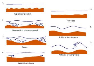
While they are often called ripples, their topography responds to hydraulic flow as well as boundary conditions, which means they are more accurately described as a type of dune. [8]
The physical parameters of the ripples, such as height and chord distance, can be used to estimate the hydraulics of the flood (e.g., depth and speed). [9]
Notable localities
North America
Giant current ripples are an important feature of the Channeled Scablands in Washington state, U.S., which formed during the Last Glacial Maximum as a result of at least 39 glacial lake bursts, called the Missoula floods, which originated from glacial lakes Columbia in Washington and Missoula in Montana. [10] [11] [12] [13]
Giant current ripples have also been identified in the Yukon Territory, Canada, where they resulted from a 30 cubic kilometres (7.2 cu mi) outburst from Neoglacial Lake Alsek. [5]
Altai Mountains, Russia
Another area where Giant current ripples are an important landscape feature is in the Altai Mountains, Russia [3] At least seven major floods are believed to have happened in this area over a span of 150,000 years during Marine Isotope Stage 2, or the latter part of the last glaciation. The lakes that fed these events reached up to 600 km3 (140 cu mi) in capacity. Floodwater depths during the largest of these floods are estimated to have been up to 300 metres (980 ft) and the water would have been moving at a speed of 60 meters per second. This resulted in giant current ripple deposits of up to a hundred meters thick. [14]
Mars

American and British geologists and planetologists have discovered giant current ripple reliefs and other scabland features on Mars surrounding the Cerberus Fossae, indicating that megafloods have occurred there at some point in the recent past. [15] While they have roughly the same dimensions as on earth when they occur, Giant current ripples appear to be much less common on Mars relative to other scabland features. This is likely a result of differences in the availability of certain types of sediment. [8]
Distribution on Earth
.svg)
References
- ^ Lewis, Reed S.; Schmidt, Keegan L. (2016-05-05). Exploring the Geology of the Inland Northwest. Geological Society of America. ISBN 978-0-8137-0041-0.
- ^ Singh, Indra Bir; Kumar, Surendra (1974-09-01). "Mega- and giant ripples in the Ganga, Yamuna, and Son Rivers, Uttar Pradesh, India". Sedimentary Geology. 12 (1): 53–66. Bibcode: 1974SedG...12...53S. doi: 10.1016/0037-0738(74)90016-5. ISSN 0037-0738.
- ^ a b c d Rudoy, Alexei N (2002-01-01). "Glacier-dammed lakes and geological work of glacial superfloods in the Late Pleistocene, Southern Siberia, Altai Mountains". Quaternary International. Holocene Studies, INQUA Commission Meeting, Sevilla 2000. 87 (1): 119–140. Bibcode: 2002QuInt..87..119R. doi: 10.1016/S1040-6182(01)00066-0. ISSN 1040-6182.
- ^ "Our Cataclysmic Floodscape" (PDF). Ice Age Flood Institute. Retrieved 2023-01-22.
- ^ a b Clarke, G (1989). "Paleohydraulic Modelling of Outburst Floods From Neoglacial Lake Alsek, Yukon Territory, Canada". Annals of Glaciology. 13: 295. Bibcode: 1989AnGla..13..295C. doi: 10.3189/S0260305500008090.
- ^ a b Lewis, Reed S.; Schmidt, Keegan L. (2016-05-05). Exploring the Geology of the Inland Northwest. Geological Society of America. ISBN 978-0-8137-0041-0.
- ^
a
b Rudoy, Alexei N (2005).
Giant current ripples (History of the Research, their diagnostics and palaeogeographical significance (in Russian). Tomsk. p. 228. Archived from
the original on 2017-10-08.
{{
cite book}}
: CS1 maint: location missing publisher ( link) - ^ a b Burr, Devon M.; Grier, Jennifer A.; McEwen, Alfred S.; Keszthelyi, Laszlo P. (2002). "Repeated Aqueous Flooding from the Cerberus Fossae: Evidence for Very Recently Extant, Deep Groundwater on Mars". Icarus. 159 (1): 53–73. Bibcode: 2002Icar..159...53B. doi: 10.1006/icar.2002.6921.
- ^ Baker, Victor R (1973). Paleohydrology and Sedimentology of Lake Missoula Flooding in Eastern Washington. Geological Society of America. p. 58. Special Paper 144.
- ^ Waitt, R.B. Jr (1985). "Case for periodic, colossal jökulhlaups from Pleistocene glacial Lake Missoula". Geological Society of America Bulletin. 96 (10): 1271–1286. Bibcode: 1985GSAB...96.1271W. doi: 10.1130/0016-7606(1985)96<1271:CFPCJF>2.0.CO;2.
-
^ Atwater, Brian F (1986).
"Pleistocene glacial-lake deposits of the Sanpoil River valley, northeastern Washington". US Geological Survey.
doi:
10.3133/b1661. Bulletin 1661.
{{
cite journal}}
: Cite journal requires|journal=( help) - ^ Hanson, M. A.; Clague, J. J. (2016). "Record of glacial lake Missoula floods in glacial lake Columbia, Washington". Quaternary Science Reviews. 133: 62–76. Bibcode: 2016QSRv..133...62H. doi: 10.1016/j.quascirev.2015.12.009.
- ^ O'Connor, J.E.; Baker, V.R.; Waitt, R.B.; Smith, L.N.; Cannon, C.M.; George, D.L.; Denlinger, R.P. (2020). "The Missoula and Bonneville floods—A review of ice-age megafloods in the Columbia River basin". Earth-Science Reviews. 79 (1): 1–53. Bibcode: 2020ESRv..20803181O. doi: 10.1016/j.earscirev.2020.103181. S2CID 219072904.
- ^ Carling, Paul A.; Martini, I. Peter; Herget, Jürgen; Borodavko, Pavel; Parnachov, Sergei (2009-09-24), "Megaflood sedimentary valley fill: Altai Mountains, Siberia", Megaflooding on Earth and Mars, Cambridge University Press, pp. 243–264, doi: 10.1017/cbo9780511635632.013, ISBN 978-0-521-86852-5
-
^ Megaflooding on Earth and Mars. Devon Burr, Victor R. Baker, Paul Carling. Cambridge, UK: Cambridge University Press. 2009.
ISBN
978-0-511-63305-8.
OCLC
667005201.
{{
cite book}}
: CS1 maint: others ( link)