| Storm Peak | |
|---|---|
 Northeast aspect | |
| Highest point | |
| Elevation | 13,495 ft (4,113 m) [1] [2] |
| Prominence | 620 ft (189 m) [2] |
| Parent peak | Tower Mountain (13,558 ft) [2] |
| Isolation | 1.37 mi (2.20 km) [2] |
| Coordinates | 37°51′34″N 107°38′51″W / 37.8594787°N 107.6475072°W [3] |
| Geography | |
 Storm Peak Location in Colorado  Storm Peak Storm Peak (the United States) | |
| Country | United States |
| State | Colorado |
| County | San Juan |
| Parent range |
Rocky Mountains San Juan Mountains [4] |
| Topo map | USGS Silverton |
| Climbing | |
| Easiest route | class 3 scrambling [2] |
Storm Peak is a 13,495-foot-elevation (4,113-meter) summit located in San Juan County, Colorado, United States.
Description
Storm Peak is situated 3.5 miles (5.6 km) north of the town of Silverton on land administered by the Bureau of Land Management. [5] It is set eight miles west of the Continental Divide in the San Juan Mountains which are a subrange of the Rocky Mountains. Precipitation runoff from the mountain drains into tributaries of the Animas River. Topographic relief is significant as the summit rises 3,500 feet (1,100 meters) above Cement Creek in 1.5 mile. The mountain has two unofficially-named subsidiary peaks: East Storm (13,325 feet), [6] and Hancock Peak (13,254 feet). [7] Storm Peak is famous for world-class expert heliskiing and the Silverton Mountain ski area on Storm's north ridge. [8] The International Speed Skiing Championship was held on Storm Mountain in 1982 and 1983. [9] The mountain's toponym has been officially adopted by the United States Board on Geographic Names, [3] and has been recorded in publications since at least 1906. [10]
Climate
According to the Köppen climate classification system, Storm Peak is located in an alpine subarctic climate zone with long, cold, snowy winters, and cool to warm summers. [11] Due to its altitude, it receives precipitation all year, as snow in winter and as thunderstorms in summer, with a dry period in late spring. Climbers can expect afternoon rain, hail, and lightning from the seasonal monsoon in late July and August.
Gallery
-
 South aspect of Storm Peak/Hancock Peak rises above Silverton.
(summit of Storm not visible) -
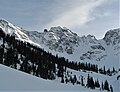 Storm's East Peak viewed from the north in winter
 -
 Heliskiing with Storm Peak and East Storm (left) in the background.
 -
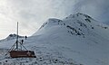 Skiers climbing the north ridge of Storm Peak
 -
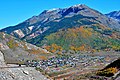
 Hancock Peak centered above Silverton, Colorado.
Storm Peak to left, and Tower Mountain to the right.
.jpg)

.jpg)


See also
References
- ^ National Geodetic Survey data sheet, STORM, ID=HL0645
- ^ a b c d e "Storm Peak - 13,495' CO". listsofjohn.com. Retrieved 2023-07-03.
- ^ a b "Storm Peak". Geographic Names Information System. United States Geological Survey, United States Department of the Interior. Retrieved 2023-07-03.
- ^ "Storm Peak, Colorado". Peakbagger.com. Retrieved 2023-07-03.
- ^ BLM Ownership map, Silverton, Colorado, blm.gov
- ^ "East Storm, Colorado". Peakbagger.com. Retrieved 2023-07-03.
- ^ "Hancock Peak, Colorado". Peakbagger.com. Retrieved 2023-07-03.
- ^ Fodor's Colorado, 9th Edition, Fodor's Travel Publications (2010), ISBN 9781400004157, p. 368.
- ^ Skiing Heritage, September 1999, p. 11.
- ^ Henry Gannett, United States Geological Survey (1906), A Gazetteer of Colorado, US Government Printing Office, p. 162.
- ^ Peel, M. C.; Finlayson, B. L.; McMahon, T. A. (2007). "Updated world map of the Köppen−Geiger climate classification". Hydrol. Earth Syst. Sci. 11. ISSN 1027-5606.
External links
- Storm Peak: weather forecast
- National Geodetic Survey data sheet
- Storm Peak (photo): Flickr
- Storm Peak ski slopes: Silvertonmountain.com
Places adjacent to Storm Peak (Colorado) | ||||||||||||||||
|---|---|---|---|---|---|---|---|---|---|---|---|---|---|---|---|---|
| ||||||||||||||||