From Wikipedia, the free encyclopedia
Mountain in the state of Colorado
| Green Mountain | |
|---|---|
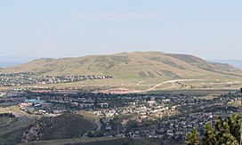
 Green Mountain viewed from
Mount Zion | |
| Highest point | |
| Elevation | 6,854 ft (2,089 m) [1] [2] |
| Prominence | 677 ft (206 m) [3] |
| Isolation | 2.96 mi (4.76 km) [3] |
| Coordinates | 39°42′03″N 105°10′40″W / 39.7009482°N 105.1777065°W / 39.7009482; -105.1777065 [1] |
| Geography | |
| Location | Jefferson County, Colorado, U.S. [4] |
| Parent range | Front Range foothills |
| Topo map |
USGS 7.5' topographic map Morrison, Colorado [1] |
| Climbing | |
| Easiest route | hike |
Green Mountain is a mesa on the eastern flank of the Front Range of the Rocky Mountains of North America. The 6,854-foot (2,089 m) mesa summit is located in William Frederick Hayden Park in the City of Lakewood, Colorado, United States, 4.0 miles (6.5 km) west ( bearing 265°) of the municipal center of Lakewood in Jefferson County. [1] [2] [3] [4]
Mesa
|
| This section is empty. You can help by
adding to it. (November 2014) |
Historical names
- Green Mountain – 1906 [4]
- Hendricks Peak
- Mount Hendricks
See also
-
 Geology portal
  Geography portal
 North America portal
 United States portal
 Colorado portal
 Mountains portal
- List of Colorado mountain ranges
- List of Colorado mountain summits
- List of Colorado county high points
References
- ^ a b c d "GREEN RESET". NGS Data Sheet. National Geodetic Survey, National Oceanic and Atmospheric Administration, United States Department of Commerce. Retrieved November 4, 2014. Note: The summit of Green Mountain is -0.20 m (-0.7 ft) lower than NGS station GREEN RESET.
- ^ a b The elevation of Green Mountain includes an adjustment of +0.990 m (+3.25 ft) from NGVD 29 to NAVD 88.
- ^ a b c "Green Mountain, Colorado". Peakbagger.com. Retrieved November 4, 2014.
- ^ a b c "Green Mountain". Geographic Names Information System. United States Geological Survey, United States Department of the Interior. Retrieved November 4, 2014.
External links
Wikimedia Commons has media related to
Green Mountain (William Frederick Hayden Park).
Denver (capital) | |
| Topics |
|
| Society | |
| Cities |
|
| Counties |
|
| Regions |
|
| Federal |
| ||||||||||||||||||||||||||||||||
|---|---|---|---|---|---|---|---|---|---|---|---|---|---|---|---|---|---|---|---|---|---|---|---|---|---|---|---|---|---|---|---|---|---|
| State |
| ||||||||||||||||||||||||||||||||
| Trails |
| ||||||||||||||||||||||||||||||||
Hidden categories:
- Articles with short description
- Short description is different from Wikidata
- Coordinates on Wikidata
- Articles to be expanded from November 2014
- All articles to be expanded
- Articles with empty sections from November 2014
- All articles with empty sections
- Articles using small message boxes
- Commons category link is on Wikidata
- All stub articles
