| Twilight Peak | |
|---|---|
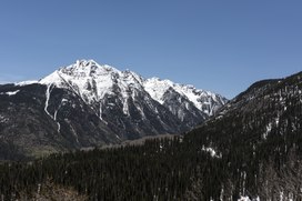 Twilight Peak from the
Million Dollar Highway | |
| Highest point | |
| Elevation | 13,163 ft (4,012 m) [1] [2] |
| Prominence | 2,338 ft (713 m) [2] |
| Isolation | 4.88 mi (7.85 km) [2] |
| Listing | |
| Coordinates | 37°39′47″N 107°43′37″W / 37.6630537°N 107.7270075°W [3] |
| Geography | |
 Twilight Peak Location in
Colorado | |
| Location | San Juan County, Colorado, U.S. [3] |
| Parent range |
San Juan Mountains, Highest summit of the West Needle Mountains [2] |
| Topo map |
USGS 7.5' topographic map Snowdon Peak, Colorado [3] |
Twilight Peak is the highest summit of the West Needle Mountains range of the San Juan Mountains System in southwestern Colorado.
The prominent 13,163-foot (4,012 m) peak is located in the Weminuche Wilderness of San Juan National Forest, 10.7 miles (17.3 km) south-southwest ( bearing 199°) of the Town of Silverton in San Juan County. [1] [2] [3]
Climbing
The standard approach to Twilight Peak is via a trail from Molas Pass to the north. The trail leads to Crater Lake from where the summit is accessible. Adjacent to Twilight Peak are North Twilight Peak (13,075 feet) and South Twilight Peak (12,932 feet).
See also
References
- ^ a b The elevation of Twilight Peak includes an adjustment of +1.537 m (+5.04 ft) from NGVD 29 to NAVD 88.
- ^ a b c d e "Twilight Peak, Colorado". Peakbagger.com. Retrieved October 22, 2014.
- ^ a b c d "Twilight Peak". Geographic Names Information System. United States Geological Survey, United States Department of the Interior. Retrieved October 22, 2014.

External links
Twilight Peak at Wikipedia's
sister projects
 Definitions from Wiktionary
 Media from Commons
 News from Wikinews
 Quotations from Wikiquote
 Texts from Wikisource
 Textbooks from Wikibooks
 Resources from Wikiversity
|
Denver (capital) | |
| Topics |
|
| Society | |
| Cities |
|
| Counties |
|
| Regions |
|
|
| This Colorado state location article is a stub. You can help Wikipedia by expanding it. |