This article needs additional citations for
verification. (May 2022) |
M24 Shin-ōtsuka Station 新大塚駅 | |||||||||||
|---|---|---|---|---|---|---|---|---|---|---|---|
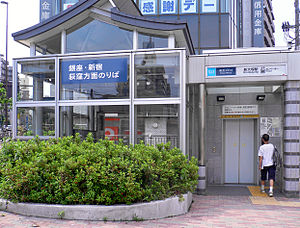
 Entrance for Shin-ōtsuka Station, Ogikubo-bound. | |||||||||||
| General information | |||||||||||
| Location | 4-51-5 Otsuka,
Bunkyō,
Tokyo Japan | ||||||||||
| Operated by |
| ||||||||||
| Line(s) | M Marunouchi Line | ||||||||||
| Platforms | 2 side platforms | ||||||||||
| Tracks | 2 | ||||||||||
| Construction | |||||||||||
| Structure type | Underground | ||||||||||
| Other information | |||||||||||
| Station code | M-24 | ||||||||||
| History | |||||||||||
| Opened | 20 January 1954 | ||||||||||
| Services | |||||||||||
| |||||||||||
| Location | |||||||||||
Shin-ōtsuka Station (新大塚駅, Shin-ōtsuka-eki) is a subway station in Bunkyō, Tokyo, Japan, operated by Tokyo Metro. Its station number is M-24. The station opened on 20 January 1954, and consists of two side platforms.
Lines
Shin-ōtsuka Station is served by the Tokyo Metro Marunouchi Line.
Station Layout
The station consists of two underground side platforms, with separate ticket gates for the corresponding platforms. In 2011, a connecting passage was completed to connect the two ticket gates together and the gates for platform 1 was renamed as the North gate and that for platform 2 as the South gate.
Platforms
| 1 | M Marunouchi Line | for Tokyo, Shinjuku, and Ogikubo |
| 2 | M Marunouchi Line | for Ikebukuro |
-
Platforms, 2017
Surroundings
History
Shin-otsuka Station opened for revenue service on 20 January 1954.
The station facilities were inherited by Tokyo Metro after the privatization of the Teito Rapid Transit Authority (TRTA) in 2004. [1]
References
- ^ "「営団地下鉄」から「東京メトロ」へ" [From "Teito Rapid Transit Authority" to "Tokyo Metro"]. Tokyo Metro Online. 8 July 2006. Archived from the original on 16 May 2012. Retrieved 29 May 2022.
External links
This article incorporates information from the corresponding article on the Japanese Wikipedia.
35°43′33″N 139°43′48″E / 35.725827°N 139.729874°E


