This article needs additional citations for
verification. (May 2022) |
M11 Yotsuya-sanchōme Station 四谷三丁目駅 | |||||||||||
|---|---|---|---|---|---|---|---|---|---|---|---|
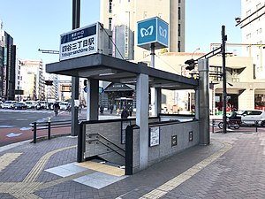
 Exit 4 in January 2019 | |||||||||||
| General information | |||||||||||
| Location |
Shinjuku,
Tokyo Japan | ||||||||||
| Operated by |
| ||||||||||
| Line(s) | M Marunouchi Line | ||||||||||
| Platforms | 2 side platforms | ||||||||||
| Tracks | 2 | ||||||||||
| Construction | |||||||||||
| Structure type | Underground | ||||||||||
| Other information | |||||||||||
| Station code | M-11 | ||||||||||
| History | |||||||||||
| Opened | 15 March 1959 | ||||||||||
| Services | |||||||||||
| |||||||||||
| Location | |||||||||||
Yotsuya-sanchōme Station (四谷三丁目駅, Yotsuya-sanchōme-eki) is a railway station in Shinjuku, Tokyo Prefecture, Japan. Its station number is M-11.
Station layout
Yotsuya-sanchōme Station consists of two side platforms. Platform one is for trains bound for Shinjuku, Ogikubo and Nakano-fujimichō, and platform two is for trains bound for Ginza and Ikebukuro. As of 2011, there is an underground passageway connecting both platforms.
Platforms
| 1 | M Marunouchi Line | for Shinjuku, Nakano-sakaue, and Ogikubo |
| 2 | M Marunouchi Line | for Ginza, Ōtemachi, and Ikebukuro |
-
The ticket gates, August 2019
-
The platform, March 2022
History
Yotsuya-sanchōme Station opened on 15 March 1959.
The station facilities were inherited by Tokyo Metro after the privatization of the Teito Rapid Transit Authority (TRTA) in 2004. [1]
Surrounding area
The station is underneath the intersection of National Route 20 (Kōshū Kaidō / Shinjuku-dōri) and Tokyo Metropolitan Route 319 (Gaien-Higashi-dōri). Other points of interest include:
- Yotsuya Police Station
- Tokyo Fire Museum
- NTT Yotsuya Building
- Sōka Gakkai headquarters
- Toei Shinjuku Line Akebonobashi Station (8 minutes walk north)
- JR East Chūō-Sōbu Line Shinanomachi Station (10 minutes walk south)
Connecting bus service
Stop: Yotsuya-Sanchome
- Shina 97 for Shinagawa Station, Shinjuku Station (west exit)
- Sō 81 for Sōdai-seimon ( Waseda University), Shibuya Station (east exit)
- Night express for Mitaka Station (north exit)
References
- ^ "「営団地下鉄」から「東京メトロ」へ" [From "Teito Rapid Transit Authority" to "Tokyo Metro"]. Tokyo Metro Online. 8 July 2006. Archived from the original on 16 May 2012. Retrieved 29 May 2022.
External links
- Tokyo Metro: Yotsuya-sanchome Station (in Japanese)


