Plymell, Kansas | |
|---|---|
 | |
 Plymell  Plymell | |
| Coordinates: 37°48′35″N 100°52′12″W / 37.80972°N 100.87000°W [1] | |
| Country | United States |
| State | Kansas |
| County | Finney |
| Elevation | 2,877 ft (877 m) |
| Time zone | UTC-6 ( CST) |
| • Summer ( DST) | UTC-5 (CDT) |
| Area code | 620 |
| FIPS code | 20-56875 [1] |
| GNIS ID | 471647 [1] |
Plymell is an unincorporated community in Finney County, Kansas, United States. [1] It is located on U.S. Route 83, 11 miles (18 km) south of Garden City.
History
A post office in Plymell was opened in 1886, closed in 1894, reopened in 1918, and reclosed in 1925. [2]
Education
The community is served by Garden City USD 457 public school district.
References
- ^ a b c d e "Plymell, Kansas", Geographic Names Information System, United States Geological Survey, United States Department of the Interior
- ^ "Kansas Post Offices, 1828-1961 (archived)". Kansas Historical Society. Archived from the original on October 9, 2013. Retrieved June 10, 2014.
Further reading
External links
Municipalities and communities of
Finney County, Kansas, United States | ||
|---|---|---|
| Cities | 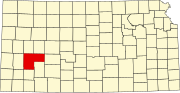 | |
|
Unincorporated communities | ||
| Ghost towns | ||
| Townships | ||
| Footnotes | †This community is designated a
Census-Designated Place (CDP) by the
United States Census Bureau. | |
|
| This article about a location in Finney County, Kansas is a stub. You can help Wikipedia by expanding it. |