| Mount Wood | |
|---|---|
 East aspect | |
| Highest point | |
| Elevation | 12,657 ft (3,858 m) [1] |
| Prominence | 177 ft (54 m) [2] |
| Parent peak | Parker Peak (12,861 ft) [3] |
| Isolation | 1.06 mi (1.71 km) [3] |
| Coordinates | 37°48′33″N 119°09′57″W / 37.8092435°N 119.1659474°W [4] |
| Naming | |
| Etymology | Captain Abram Wood [5] |
| Geography | |
 Mount Wood Location in California  Mount Wood Mount Wood (the United States) | |
| Location |
Ansel Adams Wilderness Mono County, California, U.S. |
| Parent range | Sierra Nevada |
| Topo map | USGS Koip Peak |
| Geology | |
| Age of rock | Cretaceous |
| Mountain type | Fault block |
| Type of rock | Metamorphic rock |
| Climbing | |
| First ascent | Unknown [6] |
| Easiest route | class 2 [3] East slope |
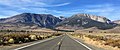
Mount Wood is a 12,657-foot-elevation (3,858 meter) mountain summit located just east of the crest of the Sierra Nevada mountain range, in Mono County of northern California, United States. [4] It is situated in the Ansel Adams Wilderness, on land managed by Inyo National Forest. It is approximately 6.0 miles (9.7 km) northwest of the community of June Lake, two miles outside of Yosemite National Park's eastern boundary, and one mile east-southeast of line parent Parker Peak. Topographic relief is significant as the summit rises over 5,500 feet (1,700 meters) above Grant Lake in three miles. The mountain is visible from the June Lake Loop.
History
This geographical feature was named in 1894 by Lieutenant Nathaniel Fish McClure who prepared a map of Yosemite Park for use by Army troops. The toponym honors Captain Abram Epperson Wood, 4th Cavalry US Army, the first acting military superintendent of Yosemite National Park from 1891 to 1893, shortly before he died in 1894. [7] The US Army had jurisdiction over Yosemite National Park from 1891 to 1914, and each summer 150 cavalrymen traveled from the Presidio of San Francisco to patrol the park. This landform's toponym has been officially adopted by the U.S. Board on Geographic Names. [4]
Climate
According to the Köppen climate classification system, Mount Wood is located in an alpine climate zone. [8] Most weather fronts originate in the Pacific Ocean, and travel east toward the Sierra Nevada mountains. As fronts approach, they are forced upward by the peaks ( orographic lift), causing them to drop their moisture in the form of rain or snowfall onto the range. Precipitation runoff from this mountain drains into Parker and Alger Creeks, both of which are tributaries of Rush Creek.
Gallery
-
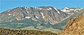
 Mount Wood (left of center), Parker Peak, Koip Peak
 -
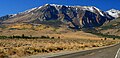
 East aspect of Mount Wood seen from Grant Lake
 -
 Mount Wood, Parker Peak, with Koip Peak in upper right corner
 -
 Mount Wood and Parker Peak seen from Panum Crater
 -
 Mount Wood, Parker Peak, Koip Peak, and Mount Lewis
 -
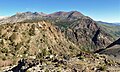 Southeast aspect of Mt. Wood seen from Rush Creek Trail near Spooky Meadow on Carson Peak. Wood is the highest peak to the right.
 -
 Mount Wood (furthest to left), Parker Peak, Koip Peak, and Mount Lewis from June Lake Loop
 -
 Mount Wood directly under the moon


.jpg)
See also
References
- ^ R.J. Secor (1992), The High Sierra: Peaks, Passes, Trails, Mountaineers Books, ISBN 9780898863130, p. 302
- ^ "Mount Wood, California". Peakbagger.com. Retrieved 2022-06-25.
- ^ a b c "Wood, Mount - 12,657' CA". listsofjohn.com. Retrieved 2022-06-25.
- ^ a b c "Mount Wood". Geographic Names Information System. United States Geological Survey, United States Department of the Interior. Retrieved 2022-06-25.
- ^ Peter Browning (1988), Yosemite Place Names: The Historic Background of Geographic Names in Yosemite National Park, Great West Books, ISBN 9780944220009, p. 170
- ^ Edward S. Robbins and Alfred W. Baxter, Jr., A Climber’s Guide to the High Sierra (1954)
- ^ Francis P. Farquhar, Place Names of the High Sierra (1926)
- ^ "Climate of the Sierra Nevada". Encyclopædia Britannica.
Places adjacent to Mount Wood (California) | ||||||||||||||||
|---|---|---|---|---|---|---|---|---|---|---|---|---|---|---|---|---|
| ||||||||||||||||