-
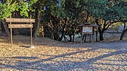 Mills Canyon Wildlife Area headwaters region
 -
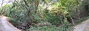 In Mills Canyon
 -
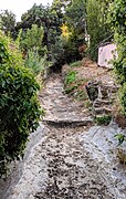 upstream of railroad tracks
 -
 Pano along railroad tracks (left) and Rollins Road (right)
 -
 At Rollins Road
 -
 Behind the Adrian Storm Station
 -
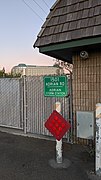 Adrian Storm Station
 -
 Upstream from Old Bayshore Highway
 -
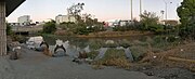
 Slough entering the Bay
| Mills Creek | |
|---|---|
   | |
| Location | |
| Country | United States |
| State | California |
| Region | San Mateo County |
| City | Burlingame |
| Physical characteristics | |
| Source | |
| • location | San Mateo County, California |
| Mouth | |
• location | Burlingame, California |
• coordinates | 37°35′50″N 122°21′57″W / 37.59733°N 122.36571°W |
• elevation | 29 ft (8.8 m) |
Mills Creek is a short eastward-flowing stream whose watershed originates in and around Mills Canyon Park in Burlingame's foothills in San Mateo County, California, United States. [1] The creek runs south of Millbrae Creek and north of Easton Creek watercourses respectively. [1]
The creek is in a mostly natural channel through the hills and residential flatlands of Burlingame. Starting near the Caltrain tracks, it is partially culverted and channelized into the San Francisco Bay. [1]
Watercourse gallery


See also
References
- ^ a b c Mills Creek Watershed, Oakland Museum of California, access date 05-27-2019
