Maylene, Alabama | |
|---|---|
 Maylene, Alabama  Maylene, Alabama | |
| Coordinates: 33°12′12″N 86°51′42″W / 33.20333°N 86.86167°W | |
| Country | United States |
| State | Alabama |
| County | Shelby |
| Elevation | 492 ft (150 m) |
| Time zone | UTC−6 ( Central (CST)) |
| • Summer ( DST) | UTC−5 (CDT) |
| ZIP code | 35114 |
| Area code(s) | 205, 659 |
| GNIS feature ID | 122423 [1] |
Maylene is an unincorporated community in Shelby County, Alabama, United States. While the community was once unincorporated, it is now part of southern Alabaster. [1] [2] Maylene has a post office with ZIP code 35114. [3] [4] One site in Maylene, the Meredith-McLaughlin House (McLaughlin Farm), is listed on the Alabama Register of Landmarks and Heritage. [5]
Notable people
- Dave Mader III, stock car racing driver
- Al Veach, former pitcher for the Philadelphia Athletics
References
- ^ a b "Maylene". Geographic Names Information System. United States Geological Survey, United States Department of the Interior.
- ^ Shelby County Highway Functional Classification System (PDF) (Map). Alabama Department of Transportation. 2004. Archived from the original (PDF) on February 21, 2014.
- ^ United States Postal Service (2012). "USPS – Look Up a ZIP Code". Retrieved February 15, 2012.
- ^ "Postmaster Finder – Post Offices by ZIP Code". United States Postal Service. Archived from the original on October 17, 2020. Retrieved June 7, 2013.
- ^ "Properties on the Alabama Register of Landmarks & Heritage". Alabama Historical Commission. www.preserveala.org. Archived from the original on September 4, 2012. Retrieved June 5, 2014.
Municipalities and communities of
Shelby County, Alabama, United States | ||
|---|---|---|
| Cities | 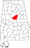 | |
| Towns | ||
| CDPs | ||
|
Other unincorporated communities | ||
| Footnotes | ‡This populated place also has portions in an adjacent county or counties | |
|
| This Shelby County, Alabama state location article is a stub. You can help Wikipedia by expanding it. |