Abbot Springs, Alabama | |
|---|---|
 One of the springs at Abbot Springs | |
 Abbot Springs, Alabama  Abbot Springs, Alabama | |
| Coordinates: 33°21′39″N 86°28′54″W / 33.36083°N 86.48167°W | |
| Country | United States |
| State | Alabama |
| County | Shelby |
| Elevation | 492 ft (150 m) |
| Time zone | UTC−6 ( Central (CST)) |
| • Summer ( DST) | UTC−5 (CDT) |
| ZIP code | 35147 |
| Area codes | 205, 659 |
| GNIS feature ID | 155974 [1] |
Abbot Springs is a settlement in Shelby County, Alabama, United States. While the community was once unincorporated, it is now part of eastern Westover. [1] [2] It lies less than 3 miles away from the town of Harpersville. It runs along a branch of Old Highway 280.
Demographics
According to the census returns from 1850 [3]-2010 [4] for Alabama, it has never reported a population figure separately on the U.S. Census. [5]
References
- ^ a b "Abbot Springs". Geographic Names Information System. United States Geological Survey, United States Department of the Interior.
- ^ Shelby County Highway Functional Classification System (PDF) (Map). Alabama Department of Transportation. 2004. Archived from the original (PDF) on February 21, 2014.
- ^ http://www2.census.gov/prod2/decennial/documents/1850c-11.pdf, 1850 Census (places)
- ^ http://www.census.gov/prod/cen2010/cph-1-2.pdf, 2010 AL Census
- ^ "US Census Bureau Publications - Census of Population and Housing".
Municipalities and communities of
Shelby County, Alabama, United States | ||
|---|---|---|
| Cities | 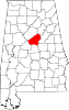 | |
| Towns | ||
| CDPs | ||
|
Other unincorporated communities | ||
| Footnotes | ‡This populated place also has portions in an adjacent county or counties | |
|
| This Shelby County, Alabama state location article is a stub. You can help Wikipedia by expanding it. |