 Ganjnameh inscriptions in 2011. | |
|
| |
| Location | Mount Alvand, Hamadan, Iran |
|---|---|
| Type | Epigraphy |
| Material | Stone |
Ganjnameh ( Persian: گنجنامه, romanized: Ganjnāme, lit. 'Treasure Book') is located 12 km southwest of Hamadan (ancient Ecbatana) in western Iran, at an altitude of c. 2000 meters across Mount Alvand. [1] [2] The site is home to two trilingual Achaemenid royal inscriptions. [1] The inscription on the upper left was created on the order of Achaemenid King Darius the Great ( r. 522–486 BC) and the one on the right by his son King Xerxes the Great ( r. 486–465 BC). [1] [2] [a]
Description
The two inscription panels of Ganjnameh, carved in stone in 20 lines on a granite rock above a creek, measure 2 × 3 m each. [1] [2] Written in Old Persian, Neo-Babylonian and Neo-Elamite, except for the different royal name, the contents of the two inscriptions are identical; Ahura Mazda receives praise, and lineages and conquests are listed. [1] [2] According to Stuart C. Brown, in the pre- Hellenistic period, this mountain was apparently the main "east-west pass" through Mount Alvand. [1] During the Achaemenid period, Ecbatana functioned as summer capital due to its high elevation and pleasant weather. [2]
The site received its name from local natives, who believed that the inscriptions contained the secret code to a hidden treasure. [2]
Gallery
-
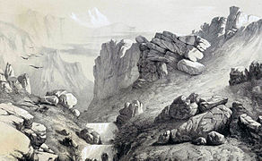 Eugène Flandin's 1840 drawing of Ganjnameh.
 -
 Pascal Coste's 1851 drawing of Ganjnameh.
 -
 Ganjnameh inscriptions in 2018.

_(cropped).jpg)

Notes
- ^ The inscription of Darius is also known as the DE inscription, and the one created by Xerxes as the XE inscription.[ citation needed]
References
Sources
- Brown, Stuart C. (2000). "Ganj-nāma". In Yarshater, Ehsan (ed.). Encyclopædia Iranica, Volume X/3: Fruit–Gāvbāzī. London and New York: Routledge & Kegan Paul. pp. 285–286. ISBN 978-0-933273-47-4.
- Kia, Mehrdad (2016). The Persian Empire: A Historical Encyclopedia [2 volumes]. ABC-CLIO. ISBN 978-1610693912.
34°45′39″N 48°26′18″E / 34.7608°N 48.4384°E
Hamadan Province, Iran | |||||||||||||||||||||
|---|---|---|---|---|---|---|---|---|---|---|---|---|---|---|---|---|---|---|---|---|---|
| Capital |  | ||||||||||||||||||||
| Counties and cities |
| ||||||||||||||||||||
| Sights |
| ||||||||||||||||||||
| populated places | |||||||||||||||||||||
| History |  | |
|---|---|---|
| Art | ||
| Architecture | ||
| Culture | ||
| Warfare |
| |
| Diplomacy | ||
| Administration | ||
| Dynasties | ||
| Related | ||