Friedrichsfelde | |
|---|---|
 | |
 Coat of arms | |
Location of Friedrichsfelde in Lichtenberg district and Berlin  | |
 Friedrichsfelde  Friedrichsfelde | |
| Coordinates: 52°30′21″N 13°31′09″E / 52.50583°N 13.51917°E | |
| Country | Germany |
| State | Berlin |
| City | Berlin |
| Borough | Lichtenberg |
| Founded | 1265 |
| Area | |
| • Total | 5.55 km2 (2.14 sq mi) |
| Elevation | 50 m (160 ft) |
| Population (2020-12-31)
[1] | |
| • Total | 55,423 |
| • Density | 10,000/km2 (26,000/sq mi) |
| Time zone | UTC+01:00 ( CET) |
| • Summer ( DST) | UTC+02:00 ( CEST) |
| Postal codes | (nr. 1101) 10315, 10319 |
| Vehicle registration | B |
| Website | Official website |
Friedrichsfelde (German pronunciation: [fʁiːdʁɪçsˈfɛldə] ⓘ) is a German locality (Ortsteil) within the borough (Bezirk) of Lichtenberg, Berlin.
History
The locality was first mentioned in a document of 1265 with the name of Rosenfelde. In 1699 it was renamed Friedrichsfelde after the Prince-Elector Frederick III of Brandenburg. [2] It was an autonomous municipality of the former Niederbarnim district until 1920, when it merged into Berlin under the " Greater Berlin Act". [3]
Geography
Located in eastern suburb of Berlin, Friedrichsfelde borders with the localities of Lichtenberg, Rummelsburg, Karlshorst, Marzahn and Biesdorf (both in Marzahn-Hellersdorf district). In its south-eastern corner is situated the " Tierpark Berlin", the second zoo of the city.
Transport
As urban rail, Friedrichsfelde is crossed both by S-Bahn and U-Bahn. The stations serving the locality are Friedrichsfelde Ost (lines S5, S7, S75), Friedrichsfelde ( U5), Tierpark (U5) and partly Rummelsburg ( S3). The quarter is also served by the tramway lines M17, 27 and 37 and traversed by the federal highways B1 and B5.
Photogallery
-
 B1/B5 road across the locality
 -
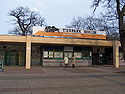 Main entrance of Tierpark
 -
 Catholic church
_-_west.jpg)


References
- ^ "Einwohnerinnen und Einwohner im Land Berlin am 31. Dezember 2020" (PDF). Amt für Statistik Berlin-Brandenburg. February 2021.
- ^ (in German) Historical infos about Friedrichsfelde
- ^ "Zeittafel Friedrichsfelde" [Friedrichsfelde timeline] (in German). Berlin-friedrichsfelde.info. Archived from the original on 2009-07-23. Retrieved 2018-09-08.
External links
![]() Media related to
Friedrichsfelde at Wikimedia Commons
Media related to
Friedrichsfelde at Wikimedia Commons
- (in German) Friedrichsfelde page on www.berlin.de
- (in German) Friedrichsfelde Event- & Informationportal for all citizens of Friedrichsfelde Archived 2019-07-21 at the Wayback Machine
| International | |
|---|---|
| National | |