Fennpfuhl | |
|---|---|
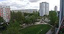
 Skyline with the
Fennpfuhlpark | |
Location of Fennpfuhl in Lichtenberg district and Berlin  | |
 Fennpfuhl  Fennpfuhl | |
| Coordinates: 52°31′42″N 13°28′27″E / 52.52833°N 13.47417°E | |
| Country | Germany |
| State | Berlin |
| City | Berlin |
| Borough | Lichtenberg |
| Founded | 1961 |
| Area | |
| • Total | 2.12 km2 (0.82 sq mi) |
| Elevation | 60 m (200 ft) |
| Population (2020-12-31)
[1] | |
| • Total | 33,751 |
| • Density | 16,000/km2 (41,000/sq mi) |
| Time zone | UTC+01:00 ( CET) |
| • Summer ( DST) | UTC+02:00 ( CEST) |
| Postal codes | (nr. 1111) 10369 |
| Vehicle registration | B |
| Website | Official website |

Fennpfuhl (German: [ˈfɛnˌp͡fuːl] ⓘ) is a German locality (Ortsteil) in the borough (Bezirk) of Lichtenberg, Berlin. With a population of 30,932 (2008) in an area of 2.12 km2 (0.82 sq mi), it is the second most densely populated locality in Berlin (14,591/km²) after Friedenau. [2]
History
In April 1961, the land development of the area, called Lichtenberg (Nord) at that time, was begun, and planning was subdivided into three sections. The area to be built upon covered an area of 175 hectares (430 acres). In the Erich-Kuttner-Straße on the edge of the area (section I), the first Plattenbau, one of the most commonly built type of residence in East Germany, was built. The building, which was built as an experimental sample, is under monument protection today. [3] On December 2, 1972, construction of the quarter began, the plan being to develop an area for almost 50,000 inhabitants. Populated since the early 1970s, it was officially completed on May 12, 1986. [4]
Geography
Fennpfuhl is situated in the eastern side of the city, on the outside edge of the Hundekopf (dog's head), the colloquial name for central Berlin surrounded by the Ringbahn. It borders the localities of Lichtenberg, Alt-Hohenschönhausen, Weißensee and Prenzlauer Berg (both in Pankow district). An urban park ( Fennpfuhlpark), characterized by numerous sculptures, is situated in the middle of the quarter.
Transport
As urban railways, the locality is served by the S-Bahn lines S4 (Ringbahn), S8 and S9, at the stations of Storkower Straße and Landsberger Allee. It is also served by the tramway lines M5, M6, M8, M13, 16 and 21.
Photo gallery
-
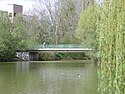 A bridge on the lake in Fennpfuhlpark
 -
 The sculpture "Große Liegende" by Siegfried Krepp in Fennpfuhlpark
 -
 Otto-Marquardt-Straße


References
- ^ "Einwohnerinnen und Einwohner im Land Berlin am 31. Dezember 2020" (PDF). Amt für Statistik Berlin-Brandenburg. February 2021. Archived from the original (PDF) on 2021-09-04. Retrieved 2021-09-21.
- ^ (in German) Boroughs, Localities, and Statistical Tracts from Berlin's Statistical Office
- ^ (in German) P2 in Berliner protected monument's list Archived 2011-09-28 at the Wayback Machine
- ^ (in German) Historical chronicles and pictures about Fennpfuhl Archived 2010-07-13 at the Wayback Machine
External links
![]() Media related to
Fennpfuhl at Wikimedia Commons
Media related to
Fennpfuhl at Wikimedia Commons
- (in German) Fennpfuhl official website Archived 2010-07-12 at the Wayback Machine
- (in German) Fennpfuhl page on www.berlin.de