
Brattle Street, which existed from 1694 to 1962, was a street in Boston, Massachusetts located on the current site of City Hall Plaza, at Government Center. [1] [2] [3]
History
|
| This section needs expansion. You can help by
adding to it. (May 2012) |
Around 1853, former Virginia slave Anthony Burns worked for "Coffin Pitts, clothing dealer, no.36 Brattle Street." [4] Nearby, abolitionist John P. Coburn managed a clothing store at 20 Brattle Street. [5] In 1850, Joshua Bowen Smith, a black abolitionist and member of Boston's Vigilance Committee, operated a catering business at 16 Brattle Street." [6]
In 1921, the first Radio Shack store opened at 46 Brattle Street. John Adams' Boston house and his law practice was on this street. During the bull dozing of Scolley Square, his house was not saved.
Gallery
-
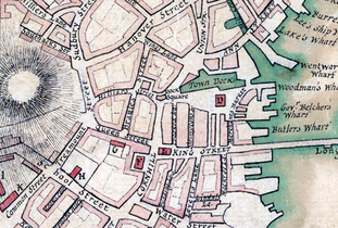 Detail of 1775 map of Boston, showing Brattle St. and vicinity
 -
 Shelton & Cheever, importers and manufacturers of "engine hose, fire buckets ... harnesses, collars, whips, carpet bags," 1852
 -
 Funeral of Abbott Lawrence, photo by Southworth & Hawes, 1855
 -
 Corner of Brattle and Court St., engraving by Winslow Homer, 1857
 -
 R. Marston & Co. Dining Rooms, ca.1881
 -
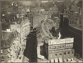 Overview of Brattle St., ca.1920
 -
 Brattle Street, Boston, 1962
 -
 Brattle St., with steps to Cornhill, Boston, 1962


See also
References
- ^ Boston (Mass.). Street laying-out Dept. (1910), A record of the streets, alleys, places, etc. in the city of Boston (2nd ed.), Boston: City of Boston Printing Dept., OL 16574538M
- ^ Walter Muir Whitehill (1968), Boston: a topographical history (2nd ed.), Cambridge, Massachusetts: Belknap Press of Harvard University Press, ISBN 0674079507, OL 21601121M, 0674079507
- ^ David Kruh (1999), Always something doing: Boston's infamous Scollay Square (Rev. ed.), Boston: Northeastern University Press, ISBN 1555534104, 1555534104
- ^ Boston slave riot, and trial of Anthony Burns: Containing the report of the Faneuil Hall meeting, the murder of Batchelder, Theodore Parker's Lesson for the day, speeches of counsel on both sides, corrected by themselves, a verbatim report of Judge Loring's decision, and detailed account of the embarkation, Boston: Fetridge and Company, 1854, OL 6948460M
- ^ Snodgrass, Mary Ellen (2015). "Coburn, John P.". The Underground Railroad: An Encyclopedia of People, Places, and Operations. Routledge. p. 123. ISBN 9781317454168.
- ^ "Universalist General Reform Association," Christian Freeman and Family Advertiser, June 7, 1850, page 2
External links
Wikimedia Commons has media related to
Brattle Street.
- Bostonian Society Archived 2010-05-09 at the Wayback Machine has materials related to Brattle Street.
