
Adams Square (1879–1963) was a square in downtown Boston, Massachusetts. Now demolished, it was formerly located on the site of the current Boston City Hall in Government Center.
History
The square was a product of the 1873–4 extension of Washington Street to Haymarket Square, [1] which created a large open space at the junction of Cornhill, Brattle, Washington, and Devonshire Streets. In 1879 the city decided to erect a statue of the Patriot and statesman Samuel Adams at this spot, and the area was accordingly given the name Adams Square that same year. [2] During its early history the square was part of a thriving retail district near the northern end of Washington Street and was the home of Leopold Morse & Co., one of the largest clothing retailers in the city. [3]
In 1898 Adams Square became a stop along the Tremont Street Subway (the predecessor to the MBTA Green Line) with the opening of Adams Square Station, whose large granite head house became the principal architectural feature of the area. [4] Subsequent alterations to the square in the early twentieth century were undertaken in an effort to relieve congestion caused by increasing automobile traffic. In 1928 the city removed the Adams statue and relocated it to adjacent Dock Square in order to improve traffic flow, and three years later the original head house of the subway station was torn down to increase driver visibility and replaced with a significantly smaller entranceway. [5]
In the mid-20th century the square was targeted for urban renewal as part of the Government Center project. It was demolished in 1963 and replaced with Boston City Hall. [6]
Images
-
 View from Dock Square toward the future site of Adams Square (center) and Brattle Street (right), 1860
 -
 Map of Adams Square, 1896
 -
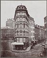
 Adams Square looking west toward Brattle Street (left) and Leopold Morse & Co. (center), c. 1895
 -
 Adams Square looking north toward Haymarket Square, during the construction of Adams Square Station, 1897
 -
 South side of Adams Square looking west toward Cornhill (left) and Brattle Street (right), 1905


.jpg)
.jpg)
.jpg)
See also
Notes
- ^ Illustrated Boston 1889, p. 66.
- ^ Smith 1880, pp. 49–54; City of Boston Street Commissioners 1910, p. 3.
- ^ Kruh 2004, p. 60; Pepe & Pepe 2009, p. 102.
- ^ Cheney & Sammarco 1997, p. 28; Belcher 2016, p. 283; Bacon 1903, p. 16.
- ^ Boston Daily Globe 1928; Boston Daily Globe 1931.
- ^ Cheney & Sammarco 1997, p. 28; Belcher 2016, pp. 285–86.
References
- Bacon, Edwin M. (1903). Boston: A Guide Book. Boston: Ginn & Company.
- Belcher, Jonathan (March 19, 2016). "Changes to Transit Service in the MBTA district, 1964-2016" (PDF). Retrieved 19 May 2016.
- Cheney, Frank; Sammarco, Anthony M. (1997). Trolleys Under the Hub. Charleston: Arcadia Publishing. ISBN 0-7524-0907-7.
- City of Boston Street Commissioners (1910). A Record of the Streets, Alleys, Places, Etc. in the City of Boston. Boston: City of Boston Printing Department.
- Illustrated Boston: The Metropolis of New England (Second ed.). New York: American Publishing and Engraving Co. 1889.
- Kruh, David (2004). Scollay Square. Charleston: Arcadia Publishing. ISBN 0-7385-3667-9.
- Pepe, William J.; Pepe, Elaine A. (2009). Boston. Charleston: Arcadia Publishing. ISBN 978-0-7385-6541-5.
- Smith, Robert Dickson (1880). Oration Delivered Before the City Council and Citizens of Boston, on the One Hundred and Fourth Anniversary of the Declaration of American Independence, July 5, 1880. Boston: Boston City Council.
- "Statue of Adams on Way to Dock Sq". Boston Daily Globe. December 6, 1928. p. 9. ProQuest 747582286.
- "Will Tear Down Adams-Sq. Station". Boston Daily Globe. July 30, 1931. p. 6. Retrieved 19 May 2016 – via ProQuest.
External links
- Adams Square - The Curse of the Bambino Musical
- Washington Street, Adams Square, Facing North, in 1954-1959 - Perpetual Form of the City, via Dome
