 Court Street, Boston, 2009 | |
| Location | Boston |
|---|---|
| West end | State Street / Washington Street |
| East end | Tremont Street / Cambridge Street |
| Construction | |
| Commissioned | July 4, 1788 |
Court Street (est. July 4, 1788) is located in the Financial District of Boston, Massachusetts. Prior to 1788, it was called Prison Lane (1634–1708) and then Queen Street (1708–1788). [1] In the 19th century it extended beyond its current length, to Bowdoin Square. In the 1960s most of Court Street was demolished to make way for the construction of Government Center. The remaining street extends a few blocks, near the Old State House on State Street. [2]
Tenants of Court Street
- Former tenants
- American Magazine of Useful and Entertaining Knowledge
- Annin & Smith, 19th-century engravers
- Boston Daily Advertiser
- Boston Gaol (Massachusetts), 1635–1822 [3]
- Concert Hall (Boston, Massachusetts)
- S.H. Gregory & Co., wallpaper, 1840s–1870s
- Elias Howe Company
- Independent Chronicle
- Charles H. Keith, music & umbrellas, 1840s–1850s
- Munroe & Francis, publishers
- The New-England Courant
- Palace Theatre
- S.S. Pierce, grocer, 19th century
- Henry Prentiss, music & umbrellas, 1830s–1850s
- New-England Museum (Boston)
- N.S. Simpkins' bookshop, 1820s
- William Tudor
- Young's Hotel (Boston)
References
- ^ Boston (Mass.). Street laying-out Dept. (1910), A record of the streets, alleys, places, etc. in the city of Boston (2 ed.), Boston: City of Boston Printing Dept., OL 16574538M
- ^ "Street Book". City of Boston. Retrieved 7 March 2010.
- ^ Boston (Mass.) (1887). Re-dedication of the Old State House (4 ed.). Boston: Printed by order of the City council. OCLC 1745196. OL 7013624M.
Images
-
 Detail of 1814 map of Boston, showing Court St. extending to Bowdoin Square
 -
 Court House, c. 1838 (engraving by Abel Bowen)
 -
 c. 1855
 -
 S. Klous & Co. Hat, Cap, and Fur Store, Court St., 1850s (illustration from Gleason's Pictorial Drawing-Room Companion)
 -
 Oriental Tea Co., 85, 87, 89 Court St. (photo by William H. Getchell)
 -
 Madame Walsh, millinery, Court St., 19th century
 -
 Scollay's building, Court St., 19th century (stereograph by John P. Soule)
 -
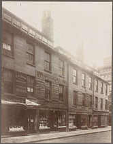 c. 1880s


Further reading
- John T. Hassam (1903). No.47 Court Street, Boston. Boston: David Clapp & Son.. ("Reprinted with additions from Notes and Queries of the Boston Transcript of Oct. 25, 1902")
External links
Wikimedia Commons has media related to
Court Street (Boston, Massachusetts).
- Bostonian Society. Photos:
- Franklin celebration, Court Street, 1856
- Intersection of Court and Tremont Streets, c. 1860
- 79-81 Court Street, c. 1870
- 89-81 Court Street, c. 1870
- Court Street at Scollay Square, c. 1870
- Corner of Court Street and Cornhill, c. 1875
- Cobb's Boston Tea Company at 71 and 73 Court Street, c. 1890
- Court Square and Court Street, January 9, 1919
- Crawford House at 17 Court Street in Scollay Square, c. 1925
- Court and Tremont Streets, Scollay Square, August 12, 1934
- Court Street and Scollay Square, c. 1955
- Cornhill and Court Street, c. 1955-65
- Intersection of Court, Cambridge and Tremont Streets, 1967
- Pilgrim Lounge at Court Street, c. 1968
- Flickr. 2005
- Flickr. 2005.
- Flickr. 2006.
- Flickr. 2006
- Flickr. Ames Building, 2007
- Flickr. 26 Court St., 2008
- Flickr. Corner of Tremont and Court, 2009
- Flickr. Corner of Tremont and Court, 2009
| Authority control databases: National |
|---|