| 1894 Atlantic hurricane season | |
|---|---|
 Season summary map | |
| Seasonal boundaries | |
| First system formed | June 6, 1894 |
| Last system dissipated | October 29, 1894 |
| Strongest storm | |
| Name | Six |
| • Maximum winds | 130 mph (215 km/h) (1-minute sustained) |
| • Lowest pressure | 931 mbar ( hPa; 27.49 inHg) |
| Seasonal statistics | |
| Total storms | 7 |
| Hurricanes | 5 |
| Major hurricanes ( Cat. 3+) | 4 |
| Total fatalities | >200 direct |
| Total damage | At least $1 million (1894 USD) |
| Related article | |
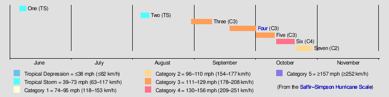
The 1894 Atlantic hurricane season ran through the summer and the first half of fall in 1894. The 1894 season was a fairly inactive one, with seven storms forming, five of which became hurricanes.
Timeline
Systems
Tropical Storm One
| Tropical storm (SSHWS) | |
 | |
| Duration | June 6 – June 9 |
|---|---|
| Peak intensity | 40 mph (65 km/h) (1-min); |
According to reanalysis by José Fernández Partagás in 1996, this system may have formed as early as June 4. However, Partagás elected to retain Simón Sarasola's 1928 narrative on this cyclone, indicating development about halfway between Cuba and Jamaica early on June 6. [1] The cyclone remained weak, peaking with maximum sustained winds of 40 mph (65 km/h) as it headed generally west-northwestward. Late on June 9, the storm was last noted near northeastern tip of the Yucatán Peninsula. [2] Flooding occurred in Cuba between Havana and Oriente Province, with the worst impacts in Santa Clara. [1]
Tropical Storm Two
| Tropical storm (SSHWS) | |
 | |
| Duration | August 5 – August 9 |
|---|---|
| Peak intensity | 60 mph (95 km/h) (1-min); |
Observations from the eastern Gulf of Mexico during the early hours of August 4 "indicated the presence of a cyclonic whirl", as noted by the Monthly Weather Review. However, due to conflicting reports, [1] the official track for this storm begins in the central Gulf of Mexico at 06:00 UTC on August 5. The cyclone moved northeastward and strengthened to reach sustained winds of 60 mph (95 km/h) about 24 hours later. By August 7, the system curved north-northwestward and made landfall near Orange Beach, Alabama, at the same intensity around 18:00 UTC. It turned to the west-northwest after moving inland, and dissipated late on August 9 over Louisiana. [2]
In the Gulf of Mexico, the schooner Violin was demasted during the storm and towed to shore by another schooner, the Henry Southers. [3] Additionally, the ship Catherine wrecked at the reef of Santa Rosa Island and the crew required rescuing. [4] The storm produced sustained winds up to 52 mph (84 km/h) at Pensacola, Florida, while heavy rains fell in areas along the Gulf Coast. [1] Precipitation generated by the storm flooded several homes in Pensacola and winds downed a number of fences and trees. [4]
Hurricane Three
| Category 3 hurricane (SSHWS) | |
 | |
| Duration | August 30 – September 9 |
|---|---|
| Peak intensity | 115 mph (185 km/h) (1-min); 948 mbar ( hPa) |
A tropical storm was first observed on August 30 near 14°N 38°W / 14°N 38°W, which is approximately 700 mi (1,125 km) west-southwest of Cape Verde. [1][ verification needed] The system slowed intensified while moving generally west-northwestward and then northwestward by September 1. Early on the following day, the storm strengthened into a hurricane. Around 18:00 UTC on September 3, the cyclone intensified into a Category 2 hurricane on the modern-day Saffir–Simpson scale and soon turned north-northwestward. The hurricane re-curved again by early on September 6 and reached Category 3 hurricane intensity later that day, peaking with winds of 115 mph (185 km/h). [2] Several steamships encountered the hurricane on September 8 and September 9, including the Othello, which observed a barometric pressure of 948 mbar (28.0 inHg), [1][ verification needed] the lowest known pressure in relation to the storm. [2] Additionally, the schooner Origin became caught in the storm, which damaged several parts of the ship and threw one person overboard, who drowned. [5] The hurricane weakened and lost tropical characteristics as it accelerated northeastward, transitioning into an extratropical cyclone about 500 mi (805 km) southeast of Greenland late on September 9. [2]
Hurricane Four
| Category 3 hurricane (SSHWS) | |

 | |
| Duration | September 18 – October 1 |
|---|---|
| Peak intensity | 120 mph (195 km/h) (1-min); 975 mbar ( hPa) |
This system was first observed well east of the Lesser Antilles on September 18. Gradually intensifying as it headed west-northwestward, the cyclone became a hurricane on September 19 and a major hurricane on the next day while passing near Martinique. After entering the Caribbean, the storm peaked with winds of 120 mph (195 km/h) on September 21, but weakened to a Category 2 hurricane before striking the Dominican Republic on September 22. The system weakened to a Category 1 hurricane before reaching the Gulf of Gonâve, but briefly became a Category 2 hurricane again before striking Cuba near Santiago de Cuba on September 23. Moving west-northwestward along or near the south coast of Cuba, the hurricane turned northward over Matanzas Province on September 24 and briefly weakened to a tropical storm. [2]
The cyclone re-intensified into a hurricane over the Straits of Florida on September 25 and struck Florida on Key West and later near Punta Rassa. After turning north-northeastward and weakening to a tropical storm, the system re-attained hurricane status shortly before entering the Atlantic on September 26. The hurricane struck near Port Royal, South Carolina, early on September 27. Thereafter, the cyclone curved east-northeastward and weakened to a tropical storm over southeastern North Carolina early on September 28. Briefly re-emerging into the Atlantic, the cyclone made its final landfall near Atlantic Beach. After again emerging into the Atlantic, the storm became a hurricane on September 29. However, the cyclone weakened back to a tropical storm on September 30 and was last noted on October 1 east of New England. [2]
On September 20, as the storm passed through the Lesser Antilles, it produced heavy rains and high winds over several islands. On Martinique, high winds and continuous, torrential rains impacted the island. Despite the intensity of the storm, there were no reports of damage in the Lesser Antilles. In Hispaniola, more than 500 homes and two churches were destroyed; numerous other structures sustained damage, mainly having their roofs blown off. The cyclone produced heavy rainfall in Florida, including 13.78 inches (350.01 mm) over a 54-hour period at Tampa; at Titusville, 7.72 inches (196.09 mm) fell in two days. Jacksonville registered a storm total of 11.11 inches (282.19 mm). [6][ not specific enough to verify] In southeast Florida, a bridge on the Lake Worth Lagoon was swept away [7] and thousands of dead fish beached at Jupiter, [8] but otherwise only gale-force winds and occurred and damage was insignificant. [9] The ship Jella was stranded at Hillsboro Inlet and the Emily II sank off Key West with a loss of all her crew. Many wine caskets and other debris were found on the beaches between the New River and the Lake Worth Lagoon. [10] In all, the cyclone was responsible for an estimated 200 deaths.
Hurricane Five
| Category 3 hurricane (SSHWS) | |

 | |
| Duration | October 1 – October 10 |
|---|---|
| Peak intensity | 120 mph (195 km/h) (1-min); 955 mbar ( hPa) |
The Florida Panhandle Hurricane of 1894
The fifth storm formed on October 1 and lasted until October 12. It formed to the northwest of the
Panama Canal, tracked northwest, and struck the
Florida Panhandle with winds of 120 mph (190 km/h), equivalent to a
major hurricane on the Saffir–Simpson hurricane scale. It tracked through
Georgia, South Carolina, North Carolina,
Connecticut,
Massachusetts,
New Hampshire,
Maine, and Canada. The hurricane caused about $1,000,000 in damage (1894 USD). 10 people were killed and 15 injured in New York City when winds blew a partially constructed building onto a
tenement. A girl died in her bed in
Englewood, New Jersey, when the roof of her house collapsed upon her. Trees and telegraph wires were blown down and boats stranded in the New York City area.
[11]
Hurricane Six
| Category 4 hurricane (SSHWS) | |
 | |
| Duration | October 11 – October 20 |
|---|---|
| Peak intensity | 130 mph (215 km/h) (1-min); 931 mbar ( hPa) |
A tropical storm formed on October 11 southeast of the Lesser Antilles as a tropical storm. It traveled north through the Lesser Antilles and later peaked with winds of 130 mph (210 km/h) and an atmospheric pressure of 27.50 inches of mercury (931.26 mb) over the open Atlantic waters several hundred miles north of Puerto Rico. Continuing to head out to sea, the hurricane weakened, and was last plotted on October 20.
Hurricane Seven
| Category 2 hurricane (SSHWS) | |
 | |
| Duration | October 21 – October 29 |
|---|---|
| Peak intensity | 110 mph (175 km/h) (1-min); 955 mbar ( hPa) |
The final storm formed on October 21 and lasted until October 31. It formed far north of the Lesser Antilles and traveled westward towards the Bahamas, but then swerved northeast and out to sea, threatening no land. Its maximum sustained winds peaked at 110 mph (161 km/h).
See also
References
- ^ a b c d e f Partagás, José Fernández (1996). A Reconstruction of Historical Tropical Cyclone Frequency in the Atlantic from Documentary and other Historical Sources: Year 1894 (PDF) (Report). National Oceanic and Atmospheric Administration. Retrieved July 3, 2023.
- ^
a
b
c
d
e
f
g
"Atlantic hurricane best track (HURDAT version 2)" (Database). United States
National Hurricane Center. April 5, 2023. Retrieved April 18, 2024.
 This article incorporates text from this source, which is in the
public domain.
This article incorporates text from this source, which is in the
public domain.
-
^
"British Schooner Disabled". Eufaula Times and News. Eufaula, Alabama. August 9, 1894. p. 1. Retrieved July 3, 2023 – via Newspapers.com.

- ^
a
b
"Storm at Pensacola". The Daily Picayune. New Orleans, Louisiana. August 9, 1894. p. 11. Retrieved July 3, 2023 – via Newspapers.com.
-
^
"Mail and Shipping Intelligence". The Times. London, United Kingdom. October 10, 1894. p. 11. Retrieved July 3, 2023 – via Newspapers.com.
- ^ Observed Rainfall in Florida, Monthly Totals from Beginning of Records to 31 December 1947. Tallahassee, Florida: Division of Water Survey and Research, State of Florida, State Board of Conservation. 1948.
- ^ "We Sometimes Think That". Tropical Sun. Juno, Florida. October 4, 1894. p. 2.
- ^ "Jupiter Jottings". Tropical Sun. Juno, Florida. October 4, 1894. p. 1.
- ^ "Lantana". Tropical Sun. Juno, Florida. October 4, 1894. p. 1.
- ^ "Storm Pick-ups". Tropical Sun. Juno, Florida. October 4, 1894. p. 1.
- ^ "Death Dealing Storm". Paterson Daily News. Paterson, New Jersey. October 10, 1894. p. 1.