-
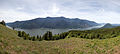
 Sandy River, 63rd longest
 -
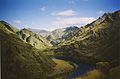
 McKenzie River, 26th longest
 -
 Columbia River, longest
 -
 North Umpqua River, 18th longest
 -
 Snake River, 2nd longest
 -
 Nestucca River, 67th longest

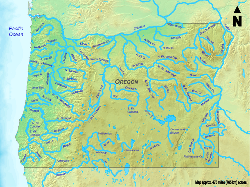
Seventy-seven rivers and creeks of at least 50 miles (80 km) in total length are the longest streams of the U.S. state of Oregon. All of these streams originate in the United States except the longest, the Columbia, which begins in the Canadian province of British Columbia and flows 1,249 miles (2,010 km) to the sea near Astoria. The second-longest, the Snake River, which at 1,078 miles (1,735 km) is the only other stream of more than 1,000 miles (1,600 km) on the list, begins in Wyoming and flows through parts of Idaho and Washington, as well as Oregon. Some of the other streams also cross borders between Oregon and California, Nevada, Idaho, or Washington, but the majority flow entirely within Oregon.
The Atlas of Oregon ranks 31 rivers in the state by average streamflow; the top five are the Columbia, Snake, Willamette, Santiam, and Umpqua. [1] Not all Oregon rivers with high average flows are on this list of longest streams because neither their main stems nor any of their tributaries (including what are called "forks") are at least 50 miles (80 km) long. High-flow streams mentioned in the Atlas but not included in this long-stream list are the Metolius, Hood, Youngs, and Coos rivers. On the other hand, the list includes four low-flow intermittent streams— Dry River, Rattlesnake Creek, Rock Creek, and Dry Creek—that cross parts of the Oregon High Desert.
The direction of Oregon stream flow is influenced by four major drainage divides: the Oregon Coast Range on the west, the Cascade Range further inland, the Klamath– Siskiyou Mountains in the southwest, and the Blue Mountains in the northeast. One set of streams, including the Nehalem River, flows directly into the Pacific Ocean or into larger streams flowing directly to the Pacific; other streams, such as the Deschutes River, flow into the Columbia River or its tributaries. A third set, including the Klamath River and its tributaries, originates in Oregon, but its waters eventually flow into northern California before reaching the ocean. Other streams like the Donner und Blitzen River flow into closed basins, such as Malheur Lake, that have no outlet to the sea. [1]
Source data for the table below came from topographic maps created by the United States Geological Survey and published on-line by TopoQuest, [2] and from the Atlas of Oregon; [1] the Oregon Atlas and Gazetteer; [3] two federally produced geographic information system (GIS) datasets—the National Hydrography Dataset and the National Watershed Boundary Dataset—and other sources as noted. In the table, total lengths are given in miles (mi) and kilometers (km), and elevations are in feet (ft) and meters (m).
Rivers and creeks

.jpg)


| Key |
|---|
| † Stream is not entirely within the state |

Map
See also
Notes and references
- Notes
- ^ Only 307 miles (494 km) of the Columbia River flow through Oregon. [8]
- ^ Only 235 miles (378 km) of the Snake River flow through Oregon. [12]
- ^ Only 198 miles (319 km) of the Owyhee River flow through Oregon. [14]
- ^ Only 46 miles (74 km) of the Klamath River flow through Oregon. [18]
- ^ Only about 144 miles (232 km) of the Grande Ronde River flow through Oregon. The river leaves Oregon and enters Washington at about river mile 39, reenters Oregon at river mile 38, and flows back into Washington at river mile 37. The distance within Oregon is the total length, 182 miles (293 km), minus the distance 38 miles (61 km) in Washington. [31]
- ^ Only 52 miles (84 km) of Jordan Creek flow through Oregon. The creek enters Oregon at about river mile 52. [11]
- ^ Only 39 miles (63 km) of Succor Creek flow through Oregon. The creek enters Oregon at about river mile 44 and leaves it at about river mile 5. [11]
- ^ Only about 46 miles (74 km) of the Lost River flow through Oregon. The river enters Oregon at about river mile 48 and leaves it at about river mile 2. [119]
- ^ About 50 miles (80 km) of the Applegate River flow through Oregon. This is the sum of the 46 miles (74 km) marked on topo maps plus the remaining distance to the California border, measured by map scale and ruler. [157]
- ^ Only 36 miles (58 km) of Cow Creek flow through Oregon. The creek enters Oregon at about river mile 36. [11]
- ^ Only about 10 miles (16 km) of the Walla Walla River flow through Oregon. The river leaves the state and enters Washington at about river mile 40. [171]
- References
- ^ a b c Allan, Buckley & Meacham 2001, pp. 162–169.
- ^ United States Geological Survey. "United States Geological Survey Topographic Map". TopoQuest. Retrieved August 19, 2010.
- ^ Oregon Atlas & Gazetteer. Freeport, Maine: Delorme Mapping. 1991. ISBN 978-0-89933-235-2.
- ^ a b Based on information in United States Geological Survey maps published on the Internet by TopoQuest, the Oregon Atlas, and the Oregon Atlas & Gazetteer. Locations are in Oregon except as noted.
- ^ a b c The mouth coordinates, mouth elevation, and source coordinates are from the Geographic Names Information System ( United States Geological Survey) listing for each river except for the source coordinates of the Columbia River, which are from the Canadian Geographical Names Data Base.
- ^ Derived from Google Earth search using Geographic Names Information System (GNIS) source coordinates.
- ^ a b c d e Kammerer, J. C. (May 1990). "Largest Rivers in the United States". United States Geological Survey. Archived from the original on January 29, 2017. Retrieved August 5, 2010.
- ^ Palmer 2014, p. 197.
- ^ "Columbia River". Geographic Names Information System. United States Geological Survey. November 28, 1980. Retrieved August 5, 2010.
- ^ "Columbia Lake". Natural Resources Canada. Archived from the original on July 6, 2011. Retrieved January 31, 2011.
- ^ a b c d e f g h i j k l m n o p q r s t u v w x y z "National Hydrography Dataset". United States Geological Survey. Retrieved September 3, 2010.
- ^ Palmer 2014, p. 259.
- ^ "Snake River". Geographic Names Information System (GNIS). United States Geological Survey. September 10, 1979. Retrieved August 6, 2010.
- ^ Palmer 2014, p. 268.
- ^ Stanford et al. 2005b, p. 647.
- ^ "Owyhee River". Geographic Names Information System (GNIS). United States Geological Survey. November 28, 1980. Retrieved August 13, 2010.
- ^ a b Carter & Resh 2005a, p. 563.
- ^ Palmer 2014, p. 227.
- ^ "Klamath River". Geographic Names Information System. United States Geological Survey (USGS). January 19, 1981. Retrieved August 16, 2010.
- ^ a b c d e f "Bull Trout Recovery Plan: Columbia River/Klamath (2002), Chapter 9: John Day River" (PDF). United States Fish and Wildlife Service. pp. iv–3. Retrieved August 12, 2010.
- ^ Palmer 2014, p. 241.
- ^ "John Day River". Geographic Names Information System (GNIS). United States Geological Survey. November 28, 1980. Retrieved August 12, 2010.
- ^ a b c d "Bull Trout Recovery Plan: Columbia River/Klamath (2002), Chapter 7: Deschutes River" (PDF). United States Fish and Wildlife Service. pp. iv–4. Retrieved August 13, 2010.
- ^ "Deschutes River". Geographic Names Information System. United States Geological Survey (USGS). November 28, 1980. Retrieved August 16, 2010.
- ^ a b Palmer 2014, p. 139.
- ^ "Rogue River". Geographic Names Information System (GNIS). United States Geological Survey. November 28, 1980. Retrieved August 8, 2010.
- ^ a b Palmer 2014, p. 271.
- ^ "Malheur River". Geographic Names Information System. United States Geological Survey (USGS). November 28, 1980. Retrieved August 16, 2010.
- ^ a b c d e f "Tributaries". Willamette Riverkeeper. Archived from the original on November 10, 2013. Retrieved August 9, 2011.
- ^ "Willamette River". Geographic Names Information System (GNIS). United States Geological Survey. November 28, 1980. Retrieved August 6, 2010.
- ^ United States Geological Survey (August 9, 2011). United States Geological Survey Topographic Map (Topographic map). Reston, VA: United States Geological Survey. Retrieved August 9, 2011 – via TopoQuest.
- ^ "Bull Trout Recovery Plan: Columbia River/Klamath (2002), Chapter 11: Grande Ronde River" (PDF). United States Fish and Wildlife Service. p. 5. Retrieved August 12, 2010.
- ^ "Grande Ronde River". Geographic Names Information System. United States Geological Survey (USGS). September 10, 1979. Retrieved August 16, 2010.
- ^ Palmer 2014, p. 276.
- ^ "Powder River". Geographic Names Information System. United States Geological Survey (USGS). November 28, 1980. Retrieved August 16, 2010.
- ^ United States Geological Survey (USGS). "United States Geological Survey Topographic Map". TopoQuest. Retrieved August 18, 2010. Map quadrants show river mileage from mouth to source.
- ^ "Crooked River". Geographic Names Information System. United States Geological Survey (USGS). November 28, 1980. Retrieved August 16, 2010.
- ^ Length derived by subtracting the main stem length of 187 miles (301 km) from the United States Geological Survey figure of 309 miles (497 km) for the main stem plus the Middle Fork
- ^ "Middle Fork Willamette River". Geographic Names Information System (GNIS). United States Geological Survey. November 28, 1980. Retrieved August 9, 2010.
- ^ a b Palmer 2014, p. 81.
- ^ "Nehalem River". Geographic Names Information System. United States Geological Survey (USGS). November 28, 1980. Retrieved August 16, 2010.
- ^ a b Palmer 2014, p. 254.
- ^ "Silvies River". Geographic Names Information System (GNIS). United States Geological Survey (USGS). November 28, 1980. Retrieved August 14, 2010.
- ^ "North Fork John Day River". Geographic Names Information System (GNIS). United States Geological Survey (USGS). November 28, 1980. Retrieved August 15, 2010.
- ^ United States Geological Survey (USGS). "United States Geological Survey Topographic Map". TopoQuest. Retrieved August 12, 2010. The map quadrants include river mile markers from mouth to source.
- ^ Carter & Resh 2005a, p. 585.
- ^ "Umpqua River". Geographic Names Information System. United States Geological Survey (USGS). November 28, 1980. Retrieved August 16, 2010.
- ^ United States Geological Survey (USGS). "United States Geological Survey Topographic Map". TopoQuest. Retrieved August 17, 2010. Map quadrangles show river mileage from mouth to source.
- ^ Palmer 2014, p. 98.
- ^ "Siuslaw River". Geographic Names Information System. United States Geological Survey (USGS). November 28, 1980. Retrieved August 16, 2010.
- ^ a b "Summary of Environmental Information on the Umpqua River Basin". National Oceanic and Atmospheric Administration. Archived from the original on January 17, 2013. Retrieved August 16, 2010.
- ^ Palmer 2014, p. 129.
- ^ "North Umpqua River". Geographic Names Information System. United States Geological Survey (USGS). November 28, 1980. Retrieved August 16, 2010.
- ^ Palmer 2014, p. 134.
- ^ "South Umpqua River". Geographic Names Information System. United States Geological Survey (USGS). November 28, 1980. Retrieved August 16, 2010.
- ^ Palmer 2014, p. 219.
- ^ "Little Deschutes River". Geographic Names Information System. United States Geological Survey (USGS). November 28, 1980. Retrieved August 16, 2010.
- ^ "Jordan – 17050108, 8 Digit Hydrologic Unit Profile" (PDF). National Resources Conservation Service. p. 2. Retrieved August 28, 2010.
- ^ "Jordan Creek". Geographic Names Information System. United States Geological Survey. November 28, 1980. Retrieved August 28, 2010.
- ^ Palmer 2014, p. 275.
- ^ "Burnt River". Geographic Names Information System. United States Geological Survey (USGS). November 28, 1980. Retrieved August 16, 2010.
- ^ a b "About the Watershed". North Santiam Watershed Council. Archived from the original on March 10, 2012. Retrieved August 9, 2010.
- ^ "North Santiam River". Geographic Names Information System (GNIS). United States Geological Survey. November 28, 1980. Retrieved August 8, 2010.
- ^ a b Palmer 2014, p. 102.
- ^ "Smith River". Geographic Names Information System (GNIS). United States Geological Survey (USGS). November 28, 1980. Retrieved August 14, 2010.
- ^ a b Palmer 2014, p. 249.
- ^ "Umatilla River". Geographic Names Information System (GNIS). United States Geological Survey (USGS). November 28, 1980. Retrieved August 14, 2010.
- ^ a b c d e f g h "Watershed Boundary Dataset". USDA, NRCS, National Cartography and Geospatial Center. Retrieved September 4, 2010. ArcExplorer GIS data viewer.
- ^ "Dry River". Geographic Names Information System. United States Geological Survey. November 28, 1980. Retrieved September 3, 2010.
- ^ a b Palmer 2014, p. 169.
- ^ "McKenzie River". Geographic Names Information System (GNIS). United States Geological Survey. November 28, 1980. Retrieved August 7, 2010.
- ^ Harney County Watershed Council (May 2000). "Silver Creek Subbasin Assessment" (PDF). Oregon Water Resources Department. p. 2. Archived (PDF) from the original on May 26, 2017. Retrieved May 23, 2017.
- ^ "Silver Creek". Geographic Names Information System. United States Geological Survey. November 28, 1980. Retrieved August 5, 2010.
- ^ a b McDowell, P.F.; O'Connor, J.E.; Lind, P. (2005). Sprague River geomorphology studies, Klamath Basin, Oregon (abstract #H31H-06) (Report). The Smithsonian/NASA Astrophysics Data System (Smithsonian Astrophysical Observatory). Bibcode: 2005AGUFM.H31H..06M. Retrieved April 11, 2011.
- ^ "Sprague River". Geographic Names Information System. United States Geological Survey (USGS). November 28, 1980. Retrieved August 16, 2010.
- ^ Taylor, Barbara (1999). "Indian Use" (PDF). Salmon and Steelhead Runs and Related Events of the Clackamas River Basin: A Historical Perspective. Portland General Electric. p. 5. Archived from the original (PDF) on March 11, 2006. Retrieved August 6, 2010.
- ^ "Clackamas River, Oregon". Geographic Names Information System. United States Geological Survey. 1980. Retrieved August 7, 2010.
- ^ a b Tualatin River Watershed Council. "Frequently Asked Questions". Tualatin River Watershed Council. Archived from the original on July 17, 2012. Retrieved August 6, 2010.
- ^ "Tualatin River". Geographic Names Information System (GNIS). United States Geological Survey. November 28, 1980. Retrieved August 6, 2010.
- ^ "Rock Creek". Geographic Names Information System (GNIS). United States Geological Survey. November 28, 1980. Retrieved September 3, 2010.
- ^ a b The Willow Creek Local Advisory Committee (March 5, 2008). "Willow Creek Agricultural Water Quality Management Area Plan" (PDF). Oregon Department of Agriculture. p. 11. Retrieved August 9, 2011.
- ^ "Willow Creek". Geographic Names Information System. United States Geological Survey. November 28, 1980. Retrieved August 23, 2010.
- ^ a b Palmer 2014, p. 255.
- ^ "Donner und Blitzen River". Geographic Names Information System. United States Geological Survey (USGS). November 28, 1980. Retrieved August 16, 2010.
- ^ "South Fork Crooked – 17070303 8-Digit Hydrologic Unit Profile" (PDF). National Resources Conservation Service (NRCS). May 2005. Archived from the original (PDF) on February 24, 2017. Retrieved September 3, 2010.
- ^ "South Fork Crooked River". Geographic Names Information System. United States Geological Survey (USGS). November 28, 1980. Retrieved September 3, 2010.
- ^ "Middle Fork John Day River". Geographic Names Information System. United States Geological Survey. November 28, 1980. Retrieved August 12, 2010.
- ^ United States Geological Survey (USGS). "United States Geological Survey Topographic Map". TopoQuest. Retrieved August 24, 2010. The maps include river mile markers for the lower 73 miles (117 km) of the river. The remaining distance is an estimate based on map scale and ruler.
- ^ "USGS Gage #14310000 on Cow Creek near Riddle, Oregon –– Water-Data Report 2009" (PDF). National Water Information System. United States Geological Survey. 2009. Retrieved August 23, 2010.
- ^ "Cow Creek". Geographic Names Information System (GNIS). United States Geological Survey (USGS). November 28, 1980. Retrieved August 18, 2010.
- ^ Palmer 2014, p. 239.
- ^ "Sycan River". Geographic Names Information System (GNIS). United States Geological Survey (USGS). November 28, 1980. Retrieved August 13, 2010.
- ^ Palmer 2014, p. 281.
- ^ "Imnaha River". Geographic Names Information System (GNIS). United States Geological Survey. November 28, 1980. Retrieved June 29, 2009.
- ^ "Calapooia River". Geographic Names Information System (GNIS). United States Geological Survey. November 28, 1980. Retrieved August 7, 2010.
- ^ Sheehan 2005, pp. 298–99.
- ^ Risley, John C.; Laenen, Antonius (1999). "Upper Klamath Lake Basin Nutrient-Loading Study—Assessment of Historic flows in the Williamson and Sprague Rivers". United States Geological Survey (USGS). Retrieved August 14, 2010.
- ^ "Williamson River". Geographic Names Information System. United States Geological Survey (USGS). November 28, 1980. Retrieved August 16, 2010.
- ^ a b Palmer 2014, p. 93.
- ^ "Siletz River". Geographic Names Information System. United States Geological Survey (USGS). November 28, 1980. Retrieved August 16, 2010.
- ^ "Mid Snake River/Succor Creek Watershed" (PDF). Idaho Department of Environmental Quality. June 2005. p. 63. Archived from the original (PDF) on November 29, 2010. Retrieved August 31, 2010.
- ^ "USGS 13173500 Succor Creek At Mouth Nr Homedale ID". United States Geological Survey. Retrieved August 31, 2010.
- ^ "Succor Creek". Geographic Names Information System. United States Geological Survey (USGS). November 28, 1980. Retrieved August 31, 2010.
- ^ United States Geological Survey. "United States Geological Survey Topographic Map". TopoQuest. Retrieved August 7, 2010. The map quadrants include river-mile markers for the stream's entire length.
- ^ "Watershed Issues". South Santiam Watershed Council. Retrieved August 9, 2010.
- ^ "South Santiam River". Geographic Names Information System (GNIS). United States Geological Survey. November 28, 1980. Retrieved August 7, 2010.
- ^ a b Palmer 2014, p. 189.
- ^ "Pudding River". Geographic Names Information System (GNIS). United States Geological Survey. November 28, 1980. Retrieved August 10, 2010.
- ^ a b c d "Introduction to the Coquille Watershed". Coquille Watershed Association. Archived from the original on November 17, 2016. Retrieved August 25, 2010.
- ^ "South Fork Coquille River". Geographic Names Information System (GNIS). United States Geological Survey. November 28, 1980. Retrieved August 25, 2010.
- ^ "West Little Owyhee River". Geographic Names Information System. United States Geological Survey (USGS). November 28, 1980. Retrieved August 31, 2010.
- ^ Bully Creek Watershed Coalition; et al. (1997). "Bully Creek Watershed Assessment and Strategy" (PDF). Oregon Department of Fish and Wildlife. p. 9. Archived (PDF) from the original on May 22, 2017. Retrieved October 3, 2015.
- ^ "Bully Creek". Geographic Names Information System. United States Geological Survey. November 28, 1980. Retrieved August 27, 2010.
- ^ Palmer 2014, p. 176.
- ^ "Luckiamute Watershed". Luckiamute Watershed Council. Archived from the original on September 8, 2015. Retrieved October 4, 2015.
- ^ "Luckiamute River". Geographic Names Information System (GNIS). United States Geological Survey. November 28, 1980. Retrieved September 2, 2010.
- ^ Cole, Michael B.; Blaha, Rich J.; Lemke, Jena L. (November 2003). "Upper South Fork of the John Day River Watershed Assessment" (PDF). Oregon Department of Fish and Wildlife. Retrieved August 21, 2010.
- ^ "South Fork John Day River". Geographic Names Information System (GNIS). United States Geological Survey (USGS). November 28, 1980. Retrieved August 12, 2010.
- ^ a b United States Geological Survey (USGS). "United States Geological Survey Topographic Map". TopoQuest. Retrieved August 17, 2010. Map quadrants show river mileage from mouth to source.
- ^ "Lost River Subbasin Agricultural Water Quality Management Area Plan" (PDF). Oregon Department of Agriculture. 2006. p. 12. Archived from the original (PDF) on October 12, 2012. Retrieved August 9, 2011.
- ^ "Lost River". Geographic Names Information System. United States Geological Survey (USGS). November 28, 1980. Retrieved August 16, 2010.
- ^ United States Geological Survey. "United States Geological Survey Topographic Map". TopoQuest. Retrieved August 8, 2010. The map quadrants include river mile (RM) markers from the mouth to RM 55 (river kilometer 89), upstream of Grand Ronde, Oregon. The remaining distance is an estimate based on map scale and ruler.
- ^ "Map 1: The Yamhill River Basin & the Chehalem Valley" (PDF). Yamhill Basin Council. 2002. Archived from the original (PDF) on December 26, 2004. Retrieved August 9, 2011. The total is the sum of five subwatersheds: Upper Yamhill, Mill Creek, Salt Creek, Lower South Yamhill/Deer Creek, and Willamina Creek.
- ^ "South Yamhill River". Geographic Names Information System. United States Geological Survey. November 28, 1980. Retrieved August 9, 2010.
- ^ Fenton, Jason. ""Use of Radio Telemetry to Document Movements of Bull Trout in the North Fork Malheur River, Oregon 2002" in Evaluation of the Life History of Native Salmonids in the Malheur River Basin" (PDF). Bonneville Power Administration. p. 5. Retrieved August 26, 2010.
- ^ Malheur Watershed Council; Burns Paiute Tribe (May 2004). "Malheur River Subbasin Assessment and Management Plan For Fish and Wildlife Mitigation" (PDF). Northwest Power and Conservation Council. Archived from the original (PDF) on February 13, 2012. Retrieved August 26, 2010.
- ^ "North Fork Malheur River". Geographic Names Information System. United States Geological Survey. November 28, 1980. Retrieved August 26, 2010.
- ^ a b Ame, John (2007). "Yaquina Watershed". Oregon State University. Retrieved October 17, 2010.
- ^ "Yaquina River". Geographic Names Information System (GNIS). United States Geological Survey (USGS). November 28, 1980. Retrieved August 14, 2010.
- ^ a b Maudlin, Michael (December 2000). "Umatilla Sub-Basin Assessment" (PDF). Washington State University. Archived from the original (PDF) on July 20, 2011. Retrieved August 24, 2010.
- ^ "Butter Creek". Geographic Names Information System (GNIS). United States Geological Survey (USGS). November 28, 1980. Retrieved August 24, 2010.
- ^ "Rattlesnake Creek". Geographic Names Information System (GNIS). United States Geological Survey (USGS). November 28, 1980. Retrieved September 3, 2010.
- ^ "Malheur River Basin Agricultural Water Quality Management Area Plan" (PDF). Oregon Department of Agriculture. February 15, 2001. p. 9. Archived from the original (PDF) on June 9, 2011. Retrieved March 5, 2011. Reference states that Willow Creek is dammed 41 miles (66 km) from its mouth. The remaining distance is an estimate based on map scale and ruler.
- ^ Malheur Watershed Council; Burns Paiute Tribe (May 2004). "Malheur River Subbasin Assessment and Management Plan For Fish and Wildlife Mitigation" (PDF). Northwest Power and Conservation Council. p. 14. Archived from the original (PDF) on February 13, 2012. Retrieved March 5, 2011.
- ^ "Willow Creek". Geographic Names Information System (GNIS). United States Geological Survey (USGS). November 28, 1980. Retrieved August 24, 2010.
- ^ a b Maguire, Mike (June 2001). "Chetco River Watershed Assessment" (PDF). South Coast Watershed Council. Retrieved August 17, 2010.
- ^ "Chetco River". Geographic Names Information System. United States Geological Survey (USGS). November 28, 1980. Retrieved August 16, 2010.
- ^ a b Palmer 2014, p. 149.
- ^ "Illinois River". Geographic Names Information System. United States Geological Survey (USGS). November 28, 1980. Retrieved August 16, 2010.
- ^ "Rock Creek". Geographic Names Information System. United States Geological Survey (USGS). November 28, 1980. Retrieved September 3, 2010.
- ^ a b Palmer 2014, p. 286.
- ^ "Wallowa River". Geographic Names Information System. United States Geological Survey (USGS). November 28, 1980. Retrieved August 16, 2010.
- ^ a b "Bull Trout Recovery Plan: Columbia River/Klamath (2002), Chapter 6: Hood River" (PDF). United States Fish and Wildlife Service. p. 4. Retrieved August 13, 2010.
- ^ "Sandy River". Geographic Names Information System. United States Geological Survey (USGS). November 28, 1980. Retrieved August 16, 2010.
- ^ "Long Tom Subbasin Fish Management Plan" (PDF). Oregon Department of Fish and Wildlife. March 1992. Archived from the original (PDF) on March 3, 2016. Retrieved September 3, 2010.
- ^ "Long Tom Watershed Assessment" (PDF). Long Tom Watershed Council. January 2000. p. 12. Archived from the original (PDF) on September 29, 2011. Retrieved September 3, 2010.
- ^ "Long Tom River". Geographic Names Information System (GNIS). United States Geological Survey (USGS). November 28, 1980. Retrieved September 3, 2010.
- ^ Clark, Jennifer Shannon (March 7, 2003). "Fifteenmile Watershed Assessment" (PDF). Wasco County Soil and Water Conservation District. Retrieved May 22, 2017.
- ^ "Fifteenmile Creek". Geographic Names Information System (GNIS). United States Geological Survey (USGS). November 28, 1980. Retrieved September 3, 2010.
- ^ "Dry Creek". Geographic Names Information System (GNIS). United States Geological Survey. November 28, 1980. Retrieved March 13, 2011.
- ^ United States Geological Survey (USGS). "United States Geological Survey Topographic Map". TopoQuest. Retrieved August 17, 2010. Map quadrangles show river mileage from the mouth to 49.7 miles (80.0 km). The remaining distance is an estimate based on map scale and ruler.
- ^ "Nestucca Bay Watershed TMDLs and Water Quality Management Plan" (PDF). Oregon Department of Environmental Quality. Archived from the original (PDF) on July 27, 2011. Retrieved August 20, 2010. Includes the watershed of the Little Nestucca River, which is a tributary of Nestucca Bay but not the Nestucca River main stem.
- ^ "Nestucca River". Geographic Names Information System. United States Geological Survey (USGS). November 28, 1980. Retrieved August 16, 2010.
- ^ "Warm Springs River". Geographic Names Information System. United States Geological Survey (USGS). November 28, 1980. Retrieved September 3, 2010.
- ^ "North Fork Coquille River". Geographic Names Information System (GNIS). United States Geological Survey. November 28, 1980. Retrieved August 25, 2010.
- ^ "Chewaucan River". Geographic Names Information System (GNIS). United States Geological Survey. November 28, 1980. Retrieved September 3, 2010.
- ^ a b "United States Geological Survey Topographic Map". Geographic Names Information System. TopoQuest. Retrieved August 17, 2010. Map quadrants show river mileage from the mouth to river mile (RM) 46 or river kilometer (RK) 74 near the intake for Applegate Dam. The remaining distance is an estimate based on map scale and ruler.
- ^ "Little Applegate River Watershed Analysis" (PDF). Bureau of Land Management. May 1995. p. 1. Retrieved August 18, 2010.
- ^ "Applegate River". Geographic Names Information System. United States Geological Survey (USGS). November 28, 1980. Retrieved August 16, 2010.
- ^ "Trout Creek Watershed Assessment" (PDF). Oregon Department of Fish and Wildlife. August 2002. Retrieved September 3, 2010.
- ^ "Trout Creek". Geographic Names Information System. United States Geological Survey (USGS). November 28, 1980. Retrieved September 3, 2010.
- ^ "USGS 13180000 Cow Creek At Danner, Oreg". United States Geological Survey. Retrieved September 3, 2010.
- ^ "Cow Creek". Geographic Names Information System. United States Geological Survey (USGS). November 28, 1980. Retrieved September 3, 2010.
- ^ "Vmap0". GIS-Lab. Retrieved September 3, 2010.
- ^ "Oregon Hydrologic Units". United States Geological Survey. 1996. Retrieved September 3, 2010.
- ^ "Crooked Creek". Geographic Names Information System (GNIS). United States Geological Survey. November 28, 1980. Retrieved September 3, 2010.
- ^ "Minam River Spring Chinook Population" (PDF). Northwest Fisheries Science Center of the National Oceanic and Atmospheric Administration. p. 2. Archived from the original (PDF) on March 4, 2016. Retrieved August 17, 2010.
- ^ "Minam River". Geographic Names Information System (GNIS). United States Geological Survey (USGS). November 28, 1980. Retrieved August 16, 2010.
- ^ United States Geological Survey. "United States Geological Survey Topographic Map". TopoQuest. Retrieved August 9, 2010. The map quadrants include river mile (RM) markers from the mouth to RM 46.3 (river kilometer 74.5). The remaining distance is an estimate based on map scale and ruler.
- ^ "Molalla River". Geographic Names Information System (GNIS). United States Geological Survey. November 28, 1980. Retrieved August 9, 2010.
- ^ a b United States Geological Survey (USGS). "United States Geological Survey Topographic Map". TopoQuest. Retrieved August 18, 2010. The maps include river mile markers for the lower 46 miles (74 km) of the river. The remaining distance is an estimate based on map scale and ruler.
- ^ "Bull Trout Recovery Plan: Columbia River/Klamath (2002), Chapter 10: Umatilla–Walla Walla" (PDF). United States Fish and Wildlife Service. pp. 2–4. Retrieved August 12, 2010.
- ^ "Walla Walla River". Geographic Names Information System (GNIS). United States Geological Survey (USGS). November 28, 1980. Retrieved August 14, 2010.
Works cited
- Allan, Stuart; Buckley, Aileen R.; Meacham, James E. (2001) [1976]. Loy, William G. (ed.). Atlas of Oregon (2 ed.). Eugene, Oregon: University of Oregon Press. ISBN 978-0-87114-101-9.
- Carter, James L.; Resh, Vincent H. (2005a). "Chapter 12: Pacific Coast Rivers of the Coterminous United States". In Benke, Arthur C.; Cushing, Colbert E. (eds.). Rivers of North America. Burlington, Massachusetts: Elsevier Academic Press. ISBN 978-0-12-088253-3.
- Palmer, Tim (2014). Field Guide to Oregon Rivers. Corvallis, Oregon: Oregon State University Press. ISBN 978-0-87071-627-0.
- Sheehan, Madelynne Diness (2005). Fishing in Oregon: The Complete Oregon Fishing Guide (10th ed.). Scappoose, Oregon: Flying Pencil Publications. ISBN 978-0-916473-15-0.
- Stanford, Jack A.; Gregory, Stanley V.; Hauer, F. Richard; Snyder, Eric B. (2005b). "Chapter 13: Columbia River Basin". In Benke, Arthur C.; Cushing, Colbert E. (eds.). Rivers of North America. Burlington, Massachusetts: Elsevier Academic Press. ISBN 978-0-12-088253-3.
External links
- Map of Oregon drainage basins published by State of Oregon Water Resources Department