Hennepin County | |
|---|---|
 The Hennepin County Government Center, located in the county seat of
Minneapolis. Its stylized letter "H" shape serves as the logo for Hennepin County. | |
.svg) Flag  Logo | |
 Location within the U.S. state of
Minnesota | |
 Minnesota's location within the
U.S. | |
| Coordinates: 44°58′33″N 93°16′00″W / 44.9758°N 93.2667°W | |
| Country | |
| State | |
| Founded | March 6, 1852 [1] |
| Named for | Louis Hennepin |
| Seat | Minneapolis |
| Largest city | Minneapolis |
| Area | |
| • Total | 607 sq mi (1,570 km2) |
| • Land | 554 sq mi (1,430 km2) |
| • Water | 53 sq mi (140 km2) 8.7% |
| Population (
2020) | |
| • Total | 1,281,565 |
| • Estimate (2023) | 1,258,713 |
| • Density | 2,313/sq mi (893/km2) |
| Time zone | UTC−6 ( Central) |
| • Summer ( DST) | UTC−5 ( CDT) |
| Area code | 612, 763, 952 |
| Congressional districts | 3rd, 5th |
| Website |
www |
Hennepin County ( /ˈhɛnəpɪn/ HEN-ə-pin) is a county in the U.S. state of Minnesota. Its county seat is Minneapolis, [2] the state's most populous city. [3] The county is named for the 17th-century explorer Louis Hennepin. [4] It extends from Minneapolis [5] to the suburbs and outlying cities in the western part of the county. Its natural areas are covered by extensive woods, hills, and lakes. [6] [7]
As of the 2020 census, the population was 1,281,565. [8] It is Minnesota's most populous county and the 34th-most populous county in the U.S.; more than one in five Minnesotans live in Hennepin County. It is included in the Minneapolis–Saint Paul–Bloomington Metropolitan Statistical Area.
History
The Territorial Legislature of Minnesota established Hennepin County on March 6, 1852, and two years later Minneapolis was named the county seat. Louis Hennepin's name was chosen because he originally named Saint Anthony Falls and recorded some of the earliest accounts of the area for the Western world. In January 1855, the first bridge over the Mississippi River was built over St. Anthony Falls. [9]
Water power built the city of Minneapolis and Hennepin County. The water of streams and rivers provided power to grist mills and sawmills throughout the county. By the late 1860s, more than a dozen mills were churning out lumber near St. Anthony Falls and the county's population had surpassed 12,000.
In many ways, the falls' power was the vital link between the central city and the farmsteads throughout the county. Farms produced vegetables, fruits, grains and dairy products for city dwellers, while Minneapolis industries produced lumber, furniture, farm implements and clothing.
By 1883, railroads united Minneapolis with both the East and West coasts, and technical developments, especially in flour milling, brought rapid progress to the area. The major Minneapolis millers were Washburn, Pillsbury, Bell, Dunwoody and Crosby. For a decade, the " Mill City" was the flour-milling capital of the world and one of the largest lumber producers. Minneapolis, with a population of 165,000 by 1890, had become a major American city, and by 1900, was firmly established as the hub of the Upper Midwest's industry and commerce.
Hennepin County's farm economy was also substantial. In 1910, farmland in the county totaled 284,000 acres, about 72% of its area. [10] The principal crops were wheat, corn, garden vegetables, and apples. The number of acres in production remained high for the next 30 years. By 1950, the amount of land devoted to agriculture had declined to 132,000 acres as development progressed in the suburbs.
During the 1950s and 1960s, many suburbs grew rapidly as housing developments, shopping centers, large school systems and growing industrialization replaced much of the open farmland. By 1970, Hennepin County's suburban population outnumbered the city's for the first time. Minneapolis's population declined by 10 percent from 1960 to 1970, while the suburban population grew by nearly 50 percent.
Another wave of immigration—which began after the Vietnam War in the mid-1970s—marked a major change in the county's ethnic makeup. This wave peaked in the 1980s when hundreds of refugees from Southeast Asia, often aided by local churches, resettled in Hennepin County. Its population surpassed one million in 1989. [11]
Geography
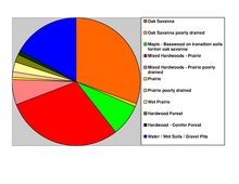
According to the United States Census Bureau, the county has an area of 607 square miles (1,570 km2), of which 554 square miles (1,430 km2) is land and 53 square miles (140 km2) (8.7%) is water. [13] Hennepin is one of 17 Minnesota counties with more savanna soils than either prairie or forest soils, and one of two Minnesota counties with more than 75% of its area in savanna soils (the other is Wright County).
The highest waterfall on the Mississippi River, Saint Anthony Falls (discovered by Louis Hennepin), is in Hennepin County next to downtown Minneapolis, but in the 19th century, the falls were converted to a series of dams. Barges and boats now pass through locks to move between the parts of the river above and below the dams.

Adjacent counties
- Anoka County (northeast)
- Ramsey County (east)
- Dakota County (southeast)
- Scott County (south)
- Carver County (southwest)
- Wright County (northwest)
- Sherburne County (north)
National protected areas
- Minnesota Valley National Wildlife Refuge (part)
- Mississippi National River and Recreation Area (part)
Demographics
| Census | Pop. | Note | %± |
|---|---|---|---|
| 1860 | 12,849 | — | |
| 1870 | 31,566 | 145.7% | |
| 1880 | 67,013 | 112.3% | |
| 1890 | 185,294 | 176.5% | |
| 1900 | 228,340 | 23.2% | |
| 1910 | 333,480 | 46.0% | |
| 1920 | 415,419 | 24.6% | |
| 1930 | 517,785 | 24.6% | |
| 1940 | 568,899 | 9.9% | |
| 1950 | 676,579 | 18.9% | |
| 1960 | 842,854 | 24.6% | |
| 1970 | 960,080 | 13.9% | |
| 1980 | 941,411 | −1.9% | |
| 1990 | 1,032,431 | 9.7% | |
| 2000 | 1,116,200 | 8.1% | |
| 2010 | 1,152,425 | 3.2% | |
| 2020 | 1,281,565 | 11.2% | |
| 2023 (est.) | 1,258,713 | [14] | −1.8% |
| U.S. Decennial Census
[15] 1790–1960 [16] 1900–1990 [17] 1990–2000 [18] 2010–2020 [19] | |||
Race and ethnicity
Hennepin County's racial and ethnic composition has evolved significantly over time. Initially, the region was inhabited by Native American tribes, primarily the Dakota Sioux. Beginning in the early 19th century, European settlement brought a demographic shift, with a predominantly white population of Northern European descent. [20] The county witnessed further diversification throughout the 20th century with the arrival of African Americans during the Great Migration, as well as Latino, Asian, and other immigrant groups in the latter half of the century. [21]
| Race/ethnicity | ||||||||
|---|---|---|---|---|---|---|---|---|
| 2020 [22] | 2010 [23] | 2000 [24] [25] | 1990 [25] [26] | |||||
| Number | % | Number | % | Number | % | Number | % | |
| White alone | 840,845 | 65.61% | 826,670 | 71.73% | 898,291 | 80.48% | 914,870 | 88.61% |
| Black alone | 169,603 | 13.23% | 134,240 | 11.65% | 99,943 | 8.95% | 60,114 | 5.82% |
| Hispanic or Latino (any race) | 98,250 | 7.67% | 77,676 | 6.74% | 45,439 | 4.07% | 13,978 | 1.35% |
| Native American alone | 8,016 | 0.63% | 8,848 | 0.77% | 11,163 | 1% | 14,912 | 1.44% |
| Asian alone | 97,348 | 7.6% | 71,535 | 6.21% | 53,555 | 4.8% | 29,258 | 2.83% |
| Other race alone | 6,515 | 0.51% | 2,752 | 0.24% | - | - | 5,496 | 0.49% |
| Two or more races | 60,988 | 4.76% | 30,704 | 2.66% | 29,041 | 2.6% | - | - |
Ancestry
The most common ancestries in Hennepin County are German, Irish, English, Norwegian and Swedish. [27]
| Ancestry [27] | Any ancestry [a] | Full ancestry [b] | ||||
|---|---|---|---|---|---|---|
| Rank | Population | % | Rank | Population | % | |
| German | 1 | 347,042 | 27.08 | 1 | 98,811 | 7.71 |
| Irish | 2 | 187,435 | 14.63 | 6 | 31,653 | 2.47 |
| English | 3 | 152,567 | 11.09 | 3 | 40,602 | 3.17 |
| Norwegian | 4 | 135,077 | 10.54 | 5 | 32,327 | 2.52 |
| Swedish | 5 | 100,544 | 7.85 | 9 | 18,886 | 1.47 |
| African | 6 | 75,484 | 5.89 | 2 | 60,478 | |
| Mexican | 7 | 57,607 | 4.50 | — | — | — |
| Polish | 8 | 54,025 | 4.22 | 11 | 10,306 | 0.80 |
| French | 9 | 52,883 | 4.13 | 16 | 4,467 | 0.35 |
| Somali | 10 | 38,588 | 3.01 | 4 | 37,897 | 2.96 |
2010
As of the 2010 census, there were 1,152,425 people, 475,913 households, and 272,885 families living in the county. The racial makeup of the county was 74.4% White, 11.8% Black or African American, 0.9% Native American, 6.2% Asian, 3.4% from other races, and 3.2% from two or more races. 6.7% of the population were Hispanic or Latino of any race.
According to the 2010–2015 American Community Survey, the largest ancestry groups were German (26.3%), Norwegian (12.6%), Irish (10.8%), and Swedish (8.3%). [28]
2000
At the 2000 census, there were 1,116,200 people, 456,129 households, and 267,291 families living in the county. The population density was 774/km2 (2,000/sq mi). There were 468,824 housing units at an average density of 325/km2 (840/sq mi). The racial makeup of the county was 80.53% White, 8.95% Black or African American, 1.00% Native American, 4.80% Asian, 0.05% Pacific Islander, 2.06% from other races, and 2.60% from two or more races. 4.07% of the population were Hispanic or Latino of any race.
There were 456,129 households, out of which 28.80% had children under the age of 18 living with them, 45.30% were married couples living together, 9.90% had a female householder with no husband present, and 41.40% were non-families. 31.80% of all households were made up of individuals, and 8.40% had someone living alone who was 65 years of age or older. The average household size was 2.39 and the average family size was 3.07.
In the county 24.00% of the population was under the age of 18, 9.70% was between 18 and 24, 33.70% from 25 to 44, 21.70% from 45 to 64, and 11.00% were 65 years of age or older. The median age was 35 years. For every 100 females there were 97.00 males. For every 100 females age 18 and over, there were 94.70 males.
The median income for a household in the county was $51,711, and the median income for a family was $65,985 (these figures had risen to $60,115 and $79,970 respectively as of a 2007 estimate). Accounting for inflation, these figures rise again to $76,202.87 for individuals, and $92,353.46 for households, adjusted for 2014 dollars. [29] Males had a median income of $42,466 versus $32,400 for females. The per capita income for the county was $28,789. About 5.00% of families and 8.30% of the population were below the poverty line, including 10.50% of those under age 18 and 5.90% of those age 65 or over.
Hennepin County is the wealthiest county in Minnesota and one of the 100 highest-income counties in the United States.
Besides English, languages with significant numbers of speakers in Hennepin County include Arabic, Hmong, Khmer, Lao, Russian, Somali, Spanish, and Vietnamese. [30]
Religious statistics
In 2010, Hennepin County's largest religious group was the Archdiocese of Saint Paul and Minneapolis, with 215,205 Catholics worshipping at 73 parishes, followed by 124,732 ELCA Lutherans with 106 congregations, 59,811 non-denominational adherents with 103 congregations, 20,286 UMC Methodists with 42 congregations, 18,836 Missouri Synod Lutherans with 34 congregations, 16,941 PC-USA Presbyterians with 21 congregations, 16,230 Converge Baptists with 26 congregations, 16,128 AoG Pentecostals with 32 congregations, 12,307 UCC Christians with 20 congregations, and 8,608 Reform Jews with 3 congregations. Altogether, religious congregations claimed 54.3% of the population as members, though members of historically African-American denominations were underrepresented due to incomplete information. [31] In 2014, Hennepin County had 708 religious organizations, the 16th-most of all U.S. counties. [32]
Law and government
Commissioners
Like all Minnesota counties, Hennepin is governed by an elected and nonpartisan board of commissioners. In Minnesota, county commissions usually have five members, but Hennepin, Ramsey, Dakota, Anoka and St. Louis counties have seven members. Each commissioner represents a district of approximately equal population. In Hennepin County, the commission appoints the medical examiner, the county auditor- treasurer, and the county recorder. The sheriff and county attorney are also elected on a nonpartisan ticket. The county government's headquarters are in downtown Minneapolis in the Hennepin County Government Center. The county oversees the Hennepin County Library system (which merged with the Minneapolis Public Library system in 2008) and Hennepin County Medical Center. The county commission also elects a chair who presides at meetings.
| District | Commissioner | In office since |
Current term expires in January |
|---|---|---|---|
| 1st | Jeff Lunde ( Republican) [33] | 2021 | 2025 [34] |
| 2nd | Irene Fernando ( DFL) [35] | 2019 | 2027 |
| 3rd | Marion Greene ( DFL) [36] (chair) [37] | 2014 | 2027 |
| 4th | Angela Conley ( DFL) [36] | 2019 | 2027 |
| 5th | Debbie Goettel ( DFL) [38] | 2017 | 2025 [34] |
| 6th | Chris LaTondresse ( DFL) [38] | 2021 | 2025 [34] |
| 7th | Kevin Anderson ( DFL) [38] | 2021 | 2025 [34] |
Key staff
Hennepin County's normal operations are coordinated by the County Administrator David Hough, Assistant County Administrator for Human Services Jodi Wentland, Assistant County Administrator for Operations Dan Rogan, Assistant County Administrator for Public Works Lisa Cerney, Assistant County Administrator for Disparity Reduction May Xiong, and Assistant County Administrator for Public Safety Chela Guzman-Wiegert. [39]
Public safety
County Sheriff
The Hennepin County Sheriff manages the county jail, patrols waterways, provides security for the District Court, handles home foreclosures, participates in homeland security activities and in law enforcement, and by state law is responsible for handling applications for permits to carry a firearm for county residents. The current county sheriff is Dawanna Witt, who was elected in 2022. [40]
Medical examiner's office
The Hennepin County Medical Examiner's office is responsible for investigating all unexpected deaths in Hennepin County as well as neighboring Dakota and Scott counties. The office determines who and why a person died, which may lead to criminal charges being filed by prosecutors. Upon request, the office may provide services for other jurisdictions. [41]
County Attorney
The Hennepin County Attorney sets policies and priorities for prosecuting criminal cases, oversees child protection and child support cases, and provides legal advice and representation to county government. The current County Attorney is Mary Moriarty, who was elected in 2022. [40]
Politics
| Year | Republican | Democratic | Third party | |||
|---|---|---|---|---|---|---|
| No. | % | No. | % | No. | % | |
| 2020 | 205,973 | 27.25% | 532,623 | 70.46% | 17,373 | 2.30% |
| 2016 | 191,770 | 28.20% | 429,288 | 63.13% | 58,919 | 8.66% |
| 2012 | 240,073 | 35.30% | 423,982 | 62.34% | 16,010 | 2.35% |
| 2008 | 231,054 | 34.81% | 420,958 | 63.42% | 11,768 | 1.77% |
| 2004 | 255,133 | 39.43% | 383,841 | 59.33% | 8,007 | 1.24% |
| 2000 | 225,657 | 39.32% | 307,599 | 53.60% | 40,590 | 7.07% |
| 1996 | 173,887 | 33.17% | 285,126 | 54.38% | 65,293 | 12.45% |
| 1992 | 179,581 | 30.61% | 278,648 | 47.50% | 128,390 | 21.89% |
| 1988 | 240,209 | 44.60% | 292,909 | 54.39% | 5,444 | 1.01% |
| 1984 | 253,921 | 47.98% | 272,401 | 51.47% | 2,912 | 0.55% |
| 1980 | 194,898 | 38.57% | 239,592 | 47.41% | 70,882 | 14.03% |
| 1976 | 211,892 | 43.84% | 257,380 | 53.25% | 14,106 | 2.92% |
| 1972 | 228,951 | 51.64% | 205,943 | 46.45% | 8,464 | 1.91% |
| 1968 | 170,002 | 41.77% | 220,078 | 54.07% | 16,944 | 4.16% |
| 1964 | 154,736 | 39.00% | 241,020 | 60.75% | 971 | 0.24% |
| 1960 | 198,992 | 51.26% | 188,250 | 48.50% | 939 | 0.24% |
| 1956 | 183,248 | 55.01% | 149,341 | 44.83% | 523 | 0.16% |
| 1952 | 180,338 | 53.49% | 155,388 | 46.09% | 1,415 | 0.42% |
| 1948 | 121,169 | 42.93% | 151,920 | 53.83% | 9,145 | 3.24% |
| 1944 | 116,781 | 43.69% | 148,792 | 55.66% | 1,747 | 0.65% |
| 1940 | 122,960 | 45.48% | 145,168 | 53.69% | 2,230 | 0.82% |
| 1936 | 81,206 | 33.08% | 144,289 | 58.78% | 19,985 | 8.14% |
| 1932 | 91,087 | 41.87% | 119,234 | 54.80% | 7,245 | 3.33% |
| 1928 | 125,472 | 60.19% | 80,851 | 38.79% | 2,124 | 1.02% |
| 1924 | 101,120 | 59.02% | 10,806 | 6.31% | 59,401 | 34.67% |
| 1920 | 90,517 | 64.58% | 28,911 | 20.63% | 20,741 | 14.80% |
| 1916 | 27,957 | 40.78% | 36,395 | 53.09% | 4,204 | 6.13% |
| 1912 | 14,379 | 29.64% | 15,530 | 32.02% | 18,596 | 38.34% |
| 1908 | 27,787 | 58.73% | 16,169 | 34.17% | 3,357 | 7.10% |
| 1904 | 31,437 | 73.71% | 5,708 | 13.38% | 5,503 | 12.90% |
| 1900 | 26,902 | 62.42% | 14,498 | 33.64% | 1,695 | 3.93% |
| 1896 | 26,786 | 55.47% | 20,515 | 42.48% | 987 | 2.04% |
| 1892 | 20,603 | 49.93% | 16,448 | 39.86% | 4,209 | 10.20% |
Like most urban counties nationwide, Hennepin County is a Democratic stronghold. It has voted Democratic in every election since 1964, except for 1972, when Richard Nixon won the county as part of a national landslide. It is also a state bellwether county, having voted for Minnesota's statewide winner in every election since 1964, the longest such streak in the state. In 2020, Joe Biden won 70% of the vote in the county, the largest percentage for any candidate since 1904. At the state level, the county is no less Democratic. For governor and U.S. Senate, the last Republicans to win the county were Arne Carlson in 1994 and David Durenberger in 1988, respectively.
Transportation
Transit
- Maple Grove Transit
- Metro Transit
- Minnesota Valley Transit Authority
- Plymouth Metrolink
- Southwest Transit
- Hawthorne Transportation Center
Major highways
-
 Interstate 35W
 -
 Interstate 94
 -
 Interstate 394
 -
 Interstate 494
 -
 Interstate 694
 -
 US Highway 12
 -
 US Highway 52
 -
 US Highway 169
 -
 US Highway 212
 -
 Minnesota State Highway 5
 -
 Minnesota State Highway 7
 -
 Minnesota State Highway 41
 -
 Minnesota State Highway 47
 -
 Minnesota State Highway 55
 -
 Minnesota State Highway 62
 -
 Minnesota State Highway 65
 -
 Minnesota State Highway 77
 -
 Minnesota State Highway 100
 -
 Minnesota State Highway 101
 -
 Minnesota State Highway 121
 -
 Minnesota State Highway 252
 -
 Minnesota State Highway 610
 -
 Hennepin County Road 17 (France Avenue)
 -
 Hennepin County Road 61
 -
 Hennepin County Road 81
 -
 Hennepin County Road 122
 - Other county roads
Airports
- Minneapolis–Saint Paul International Airport (MSP) serves the Twin Cities area. It is the 17th-busiest airport in the United States by passenger traffic and serves as a hub for Delta Air Lines.
- Crystal Airport (MIC) is a public airport in Crystal.
- Flying Cloud Airport (FCM) is a public airport in Eden Prairie.
Economy
Major companies and employers
As the economic center of Minnesota and the Upper Midwest, Hennepin County is home to many major companies in a diverse section of industries. As of the 2018 estimate, there are twelve Fortune 500 companies headquartered in Hennepin County, five of which are located in Minneapolis.
| Company Name | National Rank | Revenue ($millions),
2018 Estimate |
Headquarters City | Industry |
|---|---|---|---|---|
| UnitedHealth Group | 5 | 201,159 | Minnetonka | Managed Healthcare |
| Target | 39 | 71,879 | Minneapolis | General Retailing |
| Best Buy | 72 | 42,151 | Richfield | Electronics Retailing |
| U.S. Bancorp | 122 | 23,996 | Minneapolis | Banking and Finance |
| SuperValu | 180 | 16,009 | Eden Prairie | Food Distribution and Retailing |
| General Mills | 182 | 15,619.8 | Golden Valley | Food Processing |
| C.H. Robinson | 193 | 14,869.4 | Eden Prairie | Transportation |
| Ameriprise Financial | 252 | 12,075 | Minneapolis | Financial Services |
| Xcel Energy | 266 | 11,404 | Minneapolis | Electricity and Natural Gas Utility |
| Thrivent Financial | 343 | 8,527.9 | Minneapolis | Financial Services |
| Mosaic | 382 | 7,409.4 | Plymouth | Fertilizer Manufacturing |
| Polaris | 496 | 5,504.8 | Medina | Snowmobile Manufacturing |
.svg)
Hennepin County is also home to several major private companies such as Carlson and Cargill, both located in Minnetonka, the latter of which is the largest privately owned company in the United States. [44]
Along with these major companies, Hennepin County also contains several large employers, as listed below. According to the 2016 American Community Survey, the largest overall industries in Hennepin County are healthcare and social assistance (96,511 workers), manufacturing (80,324), and retail trade (75,861). [45]
| Employer | Number of employees | Industry |
|---|---|---|
| University of Minnesota | 18,000 | Education |
| Target Stores Inc | 10,000 | Retail |
| Pharmacy at Park Nicollet | 9,000 | Healthcare |
| Park Nicollet Methodist Hospital | 8,200 | Healthcare |
| Park Nicollet Clinic | 8,000 | Healthcare |
| M Health Fairview University of Minnesota Medical Center | 8,000 | Healthcare |
| M Health Fairview University of Minnesota Masonic Children's Hospital | 7,658 | Healthcare |
| Ameriprise Financial Inc | 7,000 | Financial Services |
| Park Nicollet Urgent Care | 7,000 | Healthcare |
| Best Buy Inc | 6,000 | Electronics Retail |
Economic indicators
According to the 2016 American Community Survey, the average household income in Hennepin County is $71,200. The GINI Index for 2016 was 0.461, lower than the national average of 0.485. [45] As of 2016, nearly 132,000 residents of Hennepin County were living under the poverty line, 10.9% of the county population. [45] This figure is lower than the national average of 14%.
Education
Tertiary education
Colleges and universities in the county include:
- Augsburg University in Minneapolis
- Dunwoody College of Technology in downtown Minneapolis
- Hamline University – Minneapolis campus in St. Louis Park
- Hennepin Technical College in Brooklyn Park and Eden Prairie
- Metropolitan State University in downtown Minneapolis and Brooklyn Park
- Minneapolis College of Art and Design in Minneapolis
- Minneapolis Community and Technical College in downtown Minneapolis
- Minnesota State University, Mankato – Twin Cities campus in Edina
- Normandale Community College in Bloomington
- North Central University in downtown Minneapolis
- North Hennepin Community College in Brooklyn Park
- Northwestern Health Sciences University in Bloomington
- St. Cloud State University – Twin Cities campus in Plymouth
- Saint Mary's University of Minnesota – Twin Cities campus in Minneapolis
- University of Minnesota – Twin Cities campus in Minneapolis
- University of St. Thomas – Minneapolis campus in downtown Minneapolis
K–12 education
School districts include: [47]
- Anoka-Hennepin Public School District
- Bloomington Public School District
- Brooklyn Center School District
- Buffalo-Hanover-Montrose Public Schools
- Delano Public School District
- Edina Public School District
- Elk River School District
- Eden Prairie Public School District
- Hopkins Public School District
- Minneapolis Public School District
- Minnetonka Public School District
- Orono Public School District
- Osseo Public School District
- Richfield Public School District
- Robbinsdale Public School District
- Rockford Public School District
- St. Anthony-New Brighton Schools
- St. Louis Park Public School District
- Waconia Public School District
- Watertown-Mayer Public School District
- Wayzata Public School District
- Westonka Public School District
Public libraries
Hennepin County Library (which Minneapolis Public Library merged into)
Recreation

Parks
Hennepin County, and particularly the city of Minneapolis, is renowned for its expansive and high-quality park system. The Minneapolis park system has been called [48] the best-designed, best-financed, and best-maintained in America. [49] It has been named the top park system in the country by the Trust for Public Land for five consecutive years as of 2017. [50] Many of Minneapolis's parks are linked by the Grand Rounds National Scenic Byway, a series of interconnected parks and paths that extends for 51 miles. The byway is divided into seven districts: Downtown Riverfront, Mississippi River, Minnehaha, Chain of Lakes, Theodore Wirth, Victory Memorial, and Northeast. [51] The byway includes many major destinations in Minneapolis, including Nicollet Island, St. Anthony Falls, Stone Arch Bridge, Mill Ruins Park, Mississippi National River and Recreation Area, Minnehaha Creek, Minnehaha Park, Lake Hiawatha, Lake Nokomis, Lake Harriet, Bde Maka Ska, Lake of the Isles, Cedar Lake, and Theodore Wirth Park.
Outside Minneapolis, Hennepin County is part of the Three Rivers Park District, a park system containing 20 parks and 10 trails spanning the Twin Cities metro area.
Culture
This section needs additional citations for
verification. (June 2020) |
Numerous art institutions in Minneapolis make Hennepin County a national center for the arts. It contains some of the country's largest and best-known centers for art, including the Minneapolis Institute of Art, Walker Art Center, Weisman Art Museum, and the Minneapolis Sculpture Garden. Major art centers include Northeast Minneapolis and the Minneapolis neighborhood of North Loop. Minneapolis is home to many important artist organizations, such as the Traffic Zone Center for Visual Art, the Handicraft Guild, and the Northeast Minneapolis Arts Association.
Hennepin County is also home to a thriving theater scene, highlighted by the Guthrie Theater in downtown Minneapolis. It is home to many theater companies, such as Mixed Blood, Skewed Visions, Brave New Workshop, and Children's Theatre Company. Other notable theaters include the Orpheum Theatre, the State Theatre, and the Pantages Theatre. Additionally, many other cities in the county are home to local community theaters, such as Eden Prairie, Minnetonka, Orono, Osseo, and Plymouth.

Sports
Of the "Big Four" sports leagues in the US, three are located in Minneapolis: the Minnesota Twins play in Target Field, the Minnesota Timberwolves play in Target Center, and the Minnesota Vikings play in U.S. Bank Stadium. Additionally, among major sports leagues, the Minnesota Lynx also play in Target Center. [52]
Cities
- Bloomington
- Brooklyn Center
- Brooklyn Park
- Champlin
- Chanhassen (partial)
- Corcoran
- Crystal
- Dayton (partial)
- Deephaven
- Eden Prairie
- Edina
- Excelsior
- Golden Valley
- Greenfield
- Greenwood
- Hanover (partial)
- Hopkins
- Independence
- Long Lake
- Loretto
- Maple Grove
- Maple Plain
- Medicine Lake
- Medina
- Minneapolis (county seat and largest municipality)
- Minnetonka
- Minnetonka Beach
- Minnetrista
- Mound
- New Hope
- Orono
- Osseo
- Plymouth
- Richfield
- Robbinsdale
- Rockford (partial)
- Rogers
- Shorewood
- Spring Park
- St. Anthony (partial)
- St. Bonifacius
- St. Louis Park
- Tonka Bay
- Wayzata
- Woodland
Unorganized territory
See also
References
- ^ "Minnesota Place Names". Minnesota Historical Society. Archived from the original on June 20, 2012. Retrieved March 18, 2014.
- ^ "Find a County". National Association of Counties. Archived from the original on May 31, 2011. Retrieved June 7, 2011.
- ^ "Our Estimates". MN State Demographic Center. Retrieved May 24, 2023.
- ^ Gannett, Henry (1905). The Origin of Certain Place Names in the United States. Govt. Print. Off. p. 155.
- ^ "Key Industries". www.greatermsp.org. Retrieved November 8, 2021.
- ^ "Managing rural and agricultural land". Hennepin County, Minnesota. Retrieved November 8, 2021.
- ^ "Natural Resources Map - Hennepin County". gis.hennepin.us. Retrieved November 8, 2021.
- ^ "State & County QuickFacts". United States Census Bureau. Retrieved April 7, 2023.
- ^ "Father Louis Hennepin Suspension Bridge | MNopedia". www.mnopedia.org. Retrieved May 24, 2023.
- ^ Administration. "Overview of Hennepin County". Hennepin County, Minnesota. Retrieved May 24, 2023.
- ^ Administration. "Overview of Hennepin County". Hennepin County, Minnesota. Retrieved September 4, 2022.
- ^ Nelson, Steven (2011). Savanna Soils of Minnesota. Minnesota: Self. pp. 49-52. ISBN 978-0-615-50320-2.
- ^ "2010 Census Gazetteer Files". United States Census Bureau. August 22, 2012. Archived from the original on October 6, 2014. Retrieved October 15, 2014.
- ^ "Annual Estimates of the Resident Population for Counties: April 1, 2020 to July 1, 2023". Retrieved March 18, 2024.
- ^ "U.S. Decennial Census". United States Census Bureau. Retrieved October 15, 2014.
- ^ "Historical Census Browser". University of Virginia Library. Retrieved October 15, 2014.
- ^ "Population of Counties by Decennial Census: 1900 to 1990". United States Census Bureau. Retrieved October 15, 2014.
- ^ "Census 2000 PHC-T-4. Ranking Tables for Counties: 1990 and 2000" (PDF). United States Census Bureau. Archived (PDF) from the original on March 27, 2010. Retrieved October 15, 2014.
- ^ "2020 Population and Housing State Data". United States Census Bureau. Retrieved August 12, 2021.
- ^ Warner, George E.; Foote, C. M. (1976). History of Hennepin County and the City of Minneapolis. Explorers and Pioneers of Minnesota; Outlines of the History of Minnesota. Marceline, MO: Walsworth. p. iv, 713. OCLC 2890166.
- ^ Delton, Jennifer A. (2002). Anne J. Aby (ed.). "Labor, Politics, and African American Identity in Minneapolis, 1930–1950". The North Star State: A Minnesota History Reader. St. Paul: Minnesota Historical Society. pp. 316–332.
- ^ "P2 HISPANIC OR LATINO, AND NOT HISPANIC OR LATINO BY RACE - 2020: DEC Redistricting Data (PL 94-171) - Hennepin County, Minnesota". United States Census Bureau.
- ^ "P2 HISPANIC OR LATINO, AND NOT HISPANIC OR LATINO BY RACE - 2010: DEC Redistricting Data (PL 94-171) - Hennepin County, Minnesota". United States Census Bureau.
- ^ "Population by Age, Sex, Race, and Hispanic or Latino Origin: 2000" (PDF). Census.gov. January 18, 2022. Retrieved November 25, 2022.
- ^ a b "Change in Hispanics". Crossroads Resource Center. September 28, 2000. Retrieved March 13, 2023.
- ^ "1990 Census of Population: General Population Characteristics Minnesota" (PDF). Census.gov. October 6, 2022. p. 21. Retrieved November 25, 2022.
- ^ a b "Detailed Race and Ethnicities in the Hennepin County, MN: 2020 Census". Tableau. September 21, 2023. Retrieved December 5, 2023.
- ^ "2015 American Community Survey". Archived from the original on February 13, 2020. Retrieved August 22, 2017.
- ^ "Inflation Calculator". www.dollartimes.com.
- ^ " Welcome Languages Archived July 8, 2010, at the Wayback Machine." Hennepin County Public Library. Retrieved on July 8, 2010.
- ^ "County Membership Report Hennepin County (Minnesota)". The Association of Religion Data Archives. 2010. Retrieved January 2, 2020.
- ^ "Social Capital Variables Spreadsheet for 2014". PennState College of Agricultural Sciences, Northeast Regional Center for Rural Development. December 8, 2017. Retrieved December 30, 2019.
- ^ "Brooklyn Park mayor defies conservative conventions, aims for state Senate". Star Tribune.
- ^ a b c d https://www.sos.state.mn.us/media/4582/2021-redistricting-guide.pdf [ bare URL PDF]
- ^ "Fernando and Yang vying for Hennepin County Commissioner in District 2". Star Tribune.
- ^ a b "Elections 101: Hennepin County Races". August 30, 2018.
- ^ "Marion Greene, District 3". Hennepin.us. Retrieved March 7, 2019.
- ^ a b c "Fresh faces on Hennepin County Board look to challenges ahead". November 11, 2020.
- ^ "Office of the county administrator".
- ^ a b "Moriarty wins Hennepin County attorney race; Witt the next county". MinnPost. November 8, 2022. Retrieved February 17, 2023.
- ^ Examiner, Medical. "Medical examiner's office". Hennepin County, Minnesota. Retrieved April 13, 2024.
- ^ Leip, David. "Dave Leip's Atlas of U.S. Presidential Elections". uselectionatlas.org.
- ^ "Fortune 500 Companies 2018: Who Made the List". Fortune. Retrieved November 15, 2018.
- ^ "America's Largest Private Companies". Forbes. Retrieved November 15, 2018.
- ^ a b c "Hennepin County, MN". Data USA. Retrieved November 26, 2018.
- ^ Team, XPAND Corporation: America's Career InfoNet Development. "America's Career InfoNet: Largest Employers". www.careerinfonet.org. Retrieved November 26, 2018.
- ^ "2020 census - school district reference map: Hennepin County, MN" (PDF). United States Census Bureau. Archived (PDF) from the original on July 22, 2022. Retrieved July 22, 2022.
- ^ “Great City Parks.” Great City Parks, by Alan Tate, Spon Press, 2004, pp. 187–192.
- ^ Cameron, Mark (December 1996). "Reviews : The American City: What Works, What Doesn't Alexander Garvin McGraw-Hill. New York, New York 1995. 475 pages. $59.95". Journal of Planning Education and Research. 16 (2): 148–149. doi: 10.1177/0739456x9601600210. ISSN 0739-456X. S2CID 144995220.
- ^ "Minneapolis parks garner top honor five years running". Southwest Journal. May 26, 2017. Retrieved December 10, 2018.
- ^ "Grand Rounds Scenic Byway System". www.minneapolisparks.org. Retrieved December 10, 2018.
- ^ "Sports Teams : Explore Minnesota". www.exploreminnesota.com. Retrieved December 10, 2018.
Notes
External links
![]() Media related to
Hennepin County, Minnesota at Wikimedia Commons
Media related to
Hennepin County, Minnesota at Wikimedia Commons
- Official website
- Hennepin County Library website
- Bloomington Convention & Visitors Bureau
- Minneapolis Northwest Convention & Visitors Bureau
Places adjacent to Hennepin County, Minnesota | ||||||||||||||||
|---|---|---|---|---|---|---|---|---|---|---|---|---|---|---|---|---|
| ||||||||||||||||
Municipalities and communities of
Hennepin County, Minnesota, United States | ||
|---|---|---|
| Cities |
|  |
|
Unincorporated area | ||
| Footnotes | ‡This populated place also has portions in an adjacent county or counties | |
| International | |
|---|---|
| National | |
| Geographic | |
| Other | |