Zolakar
Զոլաքար | |
|---|---|
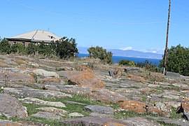
 A view of Zolakar and Lake Sevan from St. George's Church | |
 Zolakar  Zolakar | |
| Coordinates: 40°07′30″N 45°22′30″E / 40.12500°N 45.37500°E | |
| Country | Armenia |
| Province | Gegharkunik |
| Municipality | Martuni |
| Founded | 1829 |
| Elevation | 1,999 m (6,558 ft) |
| Population | |
| • Total | 6,381 |
| Time zone | UTC+4 ( AMT) |
| Postal code | 1407 |
| Zolakar at GEOnet Names Server | |
Zolakar ( Armenian: Զոլաքար), is a village in the Martuni Municipality of the Gegharkunik Province of Armenia.
Etymology
The village was known as Zolakhach until 1935.
History
The village was founded in 1829 by emigrants from Alashkert. Zolakar is home to the historic St. George's Church, Tukh Manuk chapels, as well as Bronze Age cemeteries. In the center of the village is a funerary monument. [2]
Gallery
-
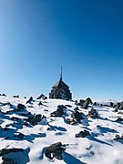
 St. George's Church of Zolakar
 -
 Khachkars in Zolakar
 -
 Zolakar cemetery
 -
 St. Hovhannes Chapel
 -
 Zolakar cemetery
 -
 Scenery around Zolakar
 -
 St. George's Church of Zolakar


References
- ^ Statistical Committee of Armenia. "The results of the 2011 Population Census of Armenia" (PDF).
- ^ Kiesling, Brady; Kojian, Raffi (2005). Rediscovering Armenia: Guide (2nd ed.). Yerevan: Matit Graphic Design Studio. p. 80. ISBN 99941-0-121-8.
External links
Wikimedia Commons has media related to
Zolakar.
- Report of the results of the 2001 Armenian Census, Statistical Committee of Armenia
- Kiesling, Brady (June 2000). Rediscovering Armenia: An Archaeological/Touristic Gazetteer and Map Set for the Historical Monuments of Armenia (PDF). Archived (PDF) from the original on 6 November 2021.

|
| This article about a location in Gegharkunik Province, Armenia is a stub. You can help Wikipedia by expanding it. |