Zhangmutou
樟木头镇 | |
|---|---|
 Zhangmutou town centre in 2006 | |
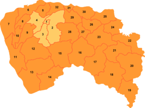
 Zhangmutou is labelled '21' on this map of Dongguan | |
| Coordinates (Zhangmutou government): 22°54′54″N 114°05′00″E / 22.9149°N 114.0833°E | |
| Country | People's Republic of China |
| Province | Guangdong |
| Prefecture-level city | Dongguan |
| Time zone | UTC+8 ( China Standard) |
| Website | dgzmt.gov.cn |
| Zhangmutou | |||||||||||||||||||||||||||||||||||||
|---|---|---|---|---|---|---|---|---|---|---|---|---|---|---|---|---|---|---|---|---|---|---|---|---|---|---|---|---|---|---|---|---|---|---|---|---|---|
| Simplified Chinese | 樟 木 头 | ||||||||||||||||||||||||||||||||||||
| Traditional Chinese | 樟 木 頭 | ||||||||||||||||||||||||||||||||||||
| Hakka | Zong1muk5tiu2 (
Meixian) Chông-muk-thèu ( Sixian) | ||||||||||||||||||||||||||||||||||||
| Literal meaning | Head of (a) camphor tree(s) | ||||||||||||||||||||||||||||||||||||
| |||||||||||||||||||||||||||||||||||||
Zhangmutou is a town under the direct jurisdiction of the prefecture-level city of Dongguan in Guangdong province, China.
Overview
It is named for the abundant camphor trees ( Chinese: 樟木; pinyin: zhāngmù) which existed at one time. It has many flats built and tailored toward expats. It is also a favorite retirement destination and attracts Hong Kong residents as the price is much lower than nearby Hong Kong. The predominant spoken languages are Hakka, Mandarin and Cantonese.
See also
Notes
References
External links
- Official website of Zhangmutou government (in Chinese)
- Zhangmutou on sun0769.com (in Chinese)
![]() Media related to
Zhangmutou at Wikimedia Commons
Media related to
Zhangmutou at Wikimedia Commons
