Wesel | |
|---|---|
 | |
 Flag  Coat of arms | |
|
| |
| Country | Germany |
| State | North Rhine-Westphalia |
| Adm. region | Düsseldorf |
| Founded | 1975 |
| Capital | Wesel |
| Government | |
| • District admin. | Ingo Brohl ( CDU) |
| Area | |
| • Total | 1,042.4 km2 (402.5 sq mi) |
| Population (31 December 2022)
[1] | |
| • Total | 465,838 |
| • Density | 450/km2 (1,200/sq mi) |
| Time zone | UTC+01:00 ( CET) |
| • Summer ( DST) | UTC+02:00 ( CEST) |
| Vehicle registration | WES,DIN,MO |
| Website |
www |
Wesel (German pronunciation: [ˈveːzl̩]) is a Kreis (district) in the northwestern part of North Rhine-Westphalia, Germany. Neighboring districts are Borken, Recklinghausen, district-free cities Bottrop, Oberhausen, Duisburg and Krefeld, districts Viersen, Cleves.
History
The district was created in 1975 by merging former districts Dinslaken, Moers and Rees, which were all created in 1816 when the area became part of Prussia. Its capital is Wesel, its most populated city is Moers.
Geography
The main river through the district is the Rhine.
Coat of arms
The coat of arms show a willow tree with 13 branches representing the 13 municipalities and cities in the district. The green color as well as the tree was chosen to show that the city is surrounded by a green belt. The coat of arms was granted in 1978.
Towns and municipalities
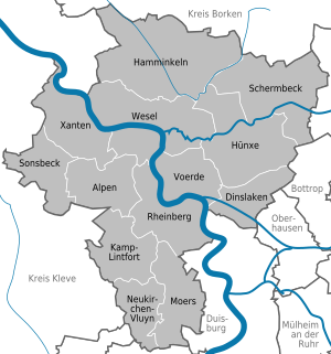
| Towns | Municipalities |
|---|---|
References
External links
![]() Media related to
Kreis Wesel at Wikimedia Commons
Media related to
Kreis Wesel at Wikimedia Commons
- Official website (German)

51°40′N 6°40′E / 51.67°N 6.67°E
| International | |
|---|---|
| National | |