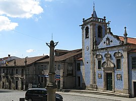
Vouzela | |
|---|---|
 | |
 | |
| Coordinates: 40°43′N 8°05′W / 40.717°N 8.083°W | |
| Country | |
| Region | Centro |
| Intermunic. comm. | Viseu Dão Lafões |
| District | Viseu |
| Parishes | 9 |
| Government | |
| • President | Rui Ladeira ( PSD) |
| Area | |
| • Total | 193.69 km2 (74.78 sq mi) |
| Population (2011) | |
| • Total | 10,564 |
| • Density | 55/km2 (140/sq mi) |
| Time zone | UTC±00:00 ( WET) |
| • Summer ( DST) | UTC+01:00 ( WEST) |
| Local holiday | May 14 |
| Website | http://www.cm-vouzela.pt/ |
Vouzela (Portuguese pronunciation: [voˈzɛlɐ] ⓘ) is a municipality in the district Viseu in Portugal. The population in 2011 was 10,564, [1] in an area of 193.69 km2. [2]
The present mayor is Rui Ladeira, elected by the Social Democratic Party. The municipal holiday is May 14.
Parishes
Administratively, the municipality is divided into 9 civil parishes ( freguesias): [3]
- Alcofra
- Cambra e Carvalhal de Vermilhas
- Campia
- Fataunços e Figueiredo das Donas
- Fornelo do Monte
- Queirã
- São Miguel do Mato
- Ventosa
- Vouzela e Paços de Vilharigues
Notable people
- Giles of Santarém (ca.1185 – 1265) a Portuguese-Dominican scholar. [4]
- João Ramalho (1493-1582) a Portuguese explorer and adventurer.
- Simão Rodrigues (1510-1579) a Portuguese-Jesuit priest and one of the co-founders of the Society of Jesus.
- Paulo Alexandre (born 1931) a Portuguese singer. [5]
- Luís Miguel Silva Tavares (born 1974) known as Luís Vouzela, a retired footballer with 510 club caps
References
- ^ Instituto Nacional de Estatística
- ^ Áreas das freguesias, concelhos, distritos e país
- ^ Diário da República. "Law nr. 11-A/2013, pages 552 142-143" (PDF) (in Portuguese). Retrieved 5 August 2014.
- ^ Ott, Michael (1909). . Catholic Encyclopedia. Vol. 06.
- ^ Paulo Alexandre, IMDb Database retrieved 24 August 2021.

