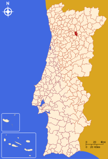
Tabuaço | |
|---|---|
 | |
 | |
| Coordinates: 41°06′N 7°34′W / 41.100°N 7.567°W | |
| Country | |
| Region | Norte |
| Intermunic. comm. | Douro |
| District | Viseu |
| Parishes | 17 |
| Government | |
| • President | Carlos Carvalho ( PSD) |
| Area | |
| • Total | 133.86 km2 (51.68 sq mi) |
| Population (2011) | |
| • Total | 6,350 |
| • Density | 47/km2 (120/sq mi) |
| Time zone | UTC±00:00 ( WET) |
| • Summer ( DST) | UTC+01:00 ( WEST) |
| Website |
www |
Tabuaço (Portuguese pronunciation: [tɐβuˈasu] ⓘ) is a municipality in the district Viseu in Portugal. The population in 2011 was 6,350, [1] in an area of 133.86 km2. [2]
The present mayor is Dr. Carlos André Teles Paulo de Carvalho, elected by the Social Democratic Party (Portugal). The municipal holiday is June 24.
Parishes
Administratively, the municipality is divided into 13 civil parishes ( freguesias): [3]
- Adorigo
- Arcos
- Barcos e Santa Leocádia
- Chavães
- Desejosa
- Granja do Tedo
- Longa
- Paradela e Granjinha
- Pinheiros e Vale de Figueira
- Sendim
- Tabuaço
- Távora e Pereiro
- Valença do Douro
Notable people
- Abel Botelho (1855/56 – 1917) a Portuguese military officer, diplomat and a distinguished Naturalism writer
References
- ^ Instituto Nacional de Estatística
- ^ Áreas das freguesias, concelhos, distritos e país
- ^ Diário da República. "Law nr. 11-A/2013, pages 552 117-118" (pdf) (in Portuguese). Retrieved 31 July 2014.
External links
Wikivoyage has a travel guide for
Tabuaço.

