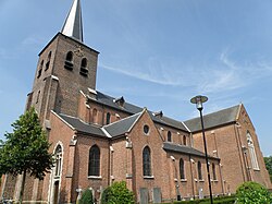
Vosselaar | |
|---|---|
 | |
| Coordinates: 51°19′N 04°53′E / 51.317°N 4.883°E | |
| Country | |
| Community | Flemish Community |
| Region | Flemish Region |
| Province | Antwerp |
| Arrondissement | Turnhout |
| Government | |
| • Mayor | Gilles Bultinck ( CD&V) |
| • Governing party/ies | CD&V |
| Area | |
| • Total | 11.83 km2 (4.57 sq mi) |
| Population (2018-01-01)
[1] | |
| • Total | 11,159 |
| • Density | 940/km2 (2,400/sq mi) |
| Postal codes | 2350 |
| NIS code | 13046 |
| Area codes | 014 |
| Website | www.vosselaar.be |
Vosselaar (Dutch pronunciation: [ˈvɔsəlaːr]) is a municipality located in the Belgian province of Antwerp. The municipality only comprises the town of Vosselaar proper. In 2021, Vosselaar had a total population of 11,443. [2] The total area is 11.85 km2.
There are three parishes: "Heieinde", Vosselaar "Dorp" and 't Looy. 't Looy is an upmarket residential area in the woods with a wide variety of large villas and landhouses. In this part of Vosselaar, many Dutch people have settled down, not only because Vosselaar is close to the Dutch border but also because Dutch people are fleeing high taxes and strict building regulations in the Netherlands. Houses here are commonly priced at €1,000,000 and over.
Notable inhabitants
- Ajit Shetty, chairman of the board of directors and Managing Director of Janssen Pharmaceutica
- Paul Janssen (Turnhout, September 12, 1926 – Rome, November 11, 2003), founder and former CEO of Janssen Pharmaceutica
- Cornelis van der Klugt, former president of the Board of Directors of Philips
References
- ^ "Wettelijke Bevolking per gemeente op 1 januari 2018". Statbel. Retrieved 9 March 2019.
- ^ "Bevolking per statistische sector - Sector 13046". Statistics Belgium. Retrieved 11 May 2022.
External links
-
 Media related to
Vosselaar at Wikimedia Commons


