-
 The view over the bridge roadway
 -
 The view from the east bank
 -
 A commemorative plaque on the bridge.
(Redirected from
Victoria Bridge (Stockton-on-Tees))
Victoria Jubilee Bridge | |
|---|---|
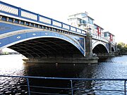
 Victoria Bridge over the river Tees | |
| Coordinates | 54°33′30″N 1°18′25″W / 54.55833°N 1.30694°W |
| Carries | Bridge Road ( A1130) |
| Crosses | River Tees |
| Locale | Borough of Stockton-on-Tees, England, United Kingdom |
| Official name | Victoria Jubilee Bridge |
| Heritage status | Grade II listed building (19 February 2010) |
| Preceded by | Surtees Rail Bridge |
| Followed by | Teesquay Millennium Bridge |
| Characteristics | |
| Design | Wrought iron arch |
| Material | Wrought and cast iron, stone and concrete |
| Total length | 341 feet (104 m) |
| Width | 60 feet (18 m) |
| Longest span | 110 feet (34 m) |
| No. of spans | 3 |
| Piers in water | 2 |
| History | |
| Designer | Harrison Haytor and Charles Neate |
| Constructed by | Whitaker Brothers of Leeds |
| Construction start | 1882 |
| Construction end | 1887 |
| Opened | 20 June 1887 |
| Location | |
|
| |
The Victoria Jubilee Bridge, also known as Victoria Bridge, is a road bridge carrying Bridge Road ( A1130) east west across the River Tees between Stockton and Thornaby in Northern England. Commonly referred to as the Victoria Bridge, it is located just south east of Stockton town centre and in the town's namesake borough.
Under an 1881 act of Parliament, the bridge was constructed (1882–1887) at a cost of £69,051 by Whitaker Brothers of Leeds, [1] [2] [3] financed by the local council, a tramway company, North East Railways and the water board, [3] and commemorates the 50th year of the reign of Queen Victoria. [3] [4] [5]
History
Before the existence of a bridge at this location communication was provided by Bishop's Ferry. [6] The first bridge was a five arch Stockton (stone) Bridge completed in 1771, designed by Joseph Robson of Sunderland. [1] [3] [4] [7] This replaced Yarm Bridge as the lowest bridge point on the River Tees and was toll free by 1820. [8]
Design
The design is a wrought-iron arch bridge by Charles Neate and consulting engineer Harrison Haytor. [1] [2] [3] The foundations of the abutments and piers are five cylindrical columns, 40 feet (12 m) deep and 14 feet (4.3 m) in diameter. [1] The abutments are faced with granite and sandstone and are filled in with large stone rubble. [7] The bridge has three arches – the centre arch is 110 feet (34 m) wide and the side arches are 85 feet (26 m). [7] The arches each have eight wrought iron ribs [1] [7] that vary in thickness from 3 feet (91 cm) at the centre to 4 feet (120 cm) at the bearings. [1] The deck is carried on buckled plates resting on secondary beams. [1] The road is 40 feet (12 m) wide and the pavement 10 feet (3 m) wide. [9] The balustrades are cast iron with an open design of interlocking circles, and on the parapets are ornamental cast-iron lampposts carrying modern lights while the spandrels are open cast-iron work with a design of diminishing interlocking circles. [2]
At either side of the bridge are land-based arches that are currently impassable on the upriver side. These were designed to allow horse-drawn barges to pass under the bridge.
Construction
Whitaker Brothers of Leeds began construction in 1882, and completed the bridge in 1887. [1] [3]
Operation
The bridge was opened on 20 June 1887. [4] [5] [7] [9] Shortly after the opening the tram system was extended over the bridge, and the bridge was to be used by trams until 1931. [3] The bridge at this point was the lowest bridge point until the opening of the Transporter Bridge in 1911 [6] and the lowest permanent bridge point until the opening of the Newport Bridge in 1934. During the second World War a bomb passed through the roadway without exploding [7] and the bridge still bears shrapnel damage from the time. [10] The bridge used to carry the A66 and A67 until the Surtees Bridge was built in 1981. In 2010 the bridge was made a grade II listed building. [2]


References
- ^ a b c d e f g h Rennison, Robert William (1996). Civil engineering heritage. ISBN 9780727725189. Retrieved 23 August 2009.
- ^ a b c d "Victoria Bridge, Thornaby". British Listed Buildings. Retrieved 25 July 2010.
- ^ a b c d e f g "Victoria Bridge, Stockton-on-Tees". Bridges on the Tyne. 2007. Retrieved 23 August 2009.
- ^ a b c Kenyon, Chris. "A Trip up the Tees". Tees Rowing Club. Archived from the original on 12 April 2009. Retrieved 23 August 2009.
- ^ a b "The Victoria Bridge at Stockton Teesside". marphotographics. Archived from the original on 21 September 2013. Retrieved 23 August 2009.
- ^ a b Delplanque, Paul (31 August 2009). "Victoria Bridge Stockton...Then and now". Gazette Live. Teesside: Evening Gazette. Archived from the original on 3 October 2011. Retrieved 25 July 2010.
- ^ a b c d e f "SINE Project, Structure Details for Victoria Bridge". Sine – Structural Images of the North East. University of Newcastle-upon-Tyne. Archived from the original on 13 June 2011. Retrieved 23 August 2009.
- ^ Page, William (1928). Parishes: Stockton on Tees. A History of the County of Durham. Vol. 3. Archived from the original on 4 June 2011. Retrieved 25 July 2010.
- ^ a b Proud, Keith (2 May 2007). "How Thornaby turned into a pottery town". The Northern Echo. NewsBank. Retrieved 3 August 2020.
- ^ Ripley, Roy; Pears, Brian. "Incidents 16th August 1940 to 28th/29th August 1940". NE Diary 1939-45. Archived from the original on 23 September 2010. Retrieved 25 July 2010.
External links
- Webpages: Bridges on the Tyne, Structurae
- Google Books: Civil engineering heritage
- Photographs: Flickr
- Historic photographs: This is Stockton on Tees.
| |||||||||||||||||||||||||||||||||||||