I'm not going to be on Wikipedia that much. Instead I'll be on Scratchpad Wikia on the New Hypothetical hurricane mini wiki. My new profile is [ [1]]
|
| |||
| Sandboxes | ||||
I love Mozilla instead of Explorer.

My Hurricane of the Day
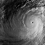
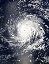
| Category 4 hurricane (SSHWS) | |

 | |
| Duration | September 6 – September 19 |
|---|---|
| Peak intensity | 155 mph (250 km/h) (1-min); 925 mbar ( hPa) |
Following the pattern of a classic Cape Verde-type storm, a large and strong area of low pressure associated with broad tropical disturbance wave emerged off Western Africa on September 6. It quickly organized and became a tropical depression during the very early morning hours of September 8 and soon became the ninth tropical storm of the season, Tropical Storm Igor. It formed farther to the east than the previous tropical cyclones in 2010, being named while southeast of the Cape Verde islands.
Interaction with another vigorous tropical low and eastern wind shear weakened the storm on September 9. The interaction and weak steering currents brought the storm almost to a halt, meandering around the Cape Verde islands before weakening to a tropical depression as it absorbed the secondary low. The storm regained tropical storm status on September 10, and began to organize again. It rapidly deepened and briefly developed an eye-like feature early on September 11, which persisted for two hours. As Igor absorbed dry air, a process called entrainment, convection decreased, and much of the convection was displaced south of Igor. The storm strengthened into a hurricane, though, late on September 11.
After some slight strengthening, the storm rapidly strengthened early on September 12, and became a Category 4 hurricane that afternoon. Further intensification continued although at a somewhat slower rate in the evening before leveling out in intensity the next morning as a strong Category 4 storm. As Igor entered an eyewall replacement cycle, its winds decreased a little, but still maintained Category 4 status. However, almost a day later, the eye became better defined, and Igor continued its strengthening streak again, nearly reaching Category 5 intensity early on September 15. It is possible that Igor may have briefly strengthened to a Category 5 hurricane that night, as to most satellite estimates indicated such strength. However, several hours later, Igor entered another larger eyewall replacement cycle, this time much more obvious, and weakened down to a lower-end Category 4 hurricane. On September 16, Igor reached a diameter of 505 miles (813 kilometres). As it headed toward Bermuda, the storm fluctuated between a moderate to strong Category 2 Hurricane. On September 19, the weakened storm battered Bermuda as a Category 1 hurricane. On September 20, the storm grew further to a size of 660 miles (1,062 kilometres). Prior to becoming fully extratropical the storm grew further to 865 miles (1,392 kilometres). During the day on September 21, eastern regions of Newfoundland experienced tropical storm and hurricane force winds. Damage due to extensive flooding, fallen trees, power outages, and at least one missing person (suspected drowning – confirmed 4 days later with recovery of the body of an 80-year-old resident), were reported. Igor became extratropical east of Newfoundland on September 21. Hurricane Igor's extratropical remnants were completely absorbed by a larger extratropical storm in Baffin Bay on September 26, and the extratropical storm moved into the Greenland glacier at southern Davis Bay, and eventually crossed the Atlantic Ocean to impact Europe.
Warnings of storm tides up to 14 feet (4.3 m) were issued by the Haitian Red Cross on September 17, for parts of Northern Haiti as Igor passed to the north.