| Mošorinska Visoravan | |
|---|---|
 Titel Hill | |
| Highest point | |
| Elevation | 128 m (420 ft) |
| Coordinates | 45°14′50″N 20°14′23″E / 45.24722°N 20.23972°E |
| Geography | |

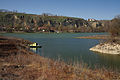
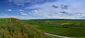
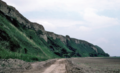
Moshorin plateau ( Serbian Cyrillic: Мошоринска Висораван) or Moshorin plateau, also known as the Titel plateau is a loess plateau situated in the Vojvodina province, Serbia. It is located in south-eastern Bačka ( Šajkaška region), between the town of Titel in the south, the villages of Glock, Vilovo and Šajkaš in the south-west, the village of Mošorin in the north, and the river Tisa in the east. It is 18 km long and 7.5 km wide, with steep cliffs, up to 60 m high along the Tisa. The hill has a flat top with an elevation of around 100 to maximally 128 m. The cliffs and the flat top give it a mesa-like appearance. The hill is an interesting geographical feature because it is the only hill in Bačka region, most of which is a flat plain. It is a loess formation deposited during the Pleistocene, showing six distinct bands, visible in gullies at the edge. [1]
The plateau was the site of Bronze Age settlements, notably the large fortified settlement of Feudvar belonging to the Vatin culture. [2]
Gallery
-
-
-

-
-
 Aerial view of the Feudvar Bronze Age settlement site
 -
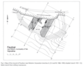 Map of the Fedvar site
 -
 The Plateau in the Early and Middle Bronze Age ( Vatin culture)


_and_Middle_Bronze_Age_Vatin_culture_(horizon_13)_(after_Falkenstein_1998,_Fig._234-236).png)
See also
References
External links
|
| This Serbia location article is a stub. You can help Wikipedia by expanding it. |