| Goč | |
|---|---|
 | |
| Highest point | |
| Elevation | 1,127 m (3,698 ft) [1] |
| Coordinates | 43°32′11″N 20°50′44″E / 43.53639°N 20.84556°E |
| Geography | |
 Goč Location in Serbia | |
| Location | Central Serbia |
Goč ( Serbian Cyrillic: Гоч) is a mountain in central Serbia, about 15 km south of the spa town of Vrnjačka Banja. It belongs to the northern part of the Kopaonik mountain range and its highest peak, Krnja jela ( Serbian Cyrillic: Крња јела), has an elevation of 1,127 m (3,698 ft). [2]
Goč is a popular hiking and mountaineering destination and the village Goč is a small ski resort. The skiing area is equipped with a single-seater ski lift and the longest slope is 1,500 m long and 40 m wide. [3] The skiing area is located on the mountain Krst (Serbian Cyrillic: Крст) with an elevation of 1,123 m (3,684 ft). An artificial lake, Selište, is located in the area as well.
Gallery
-
 Lake Selište
 -
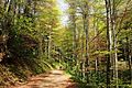 Deciduous forest road
 -
 Hiking on Goč mountain in winter
 -
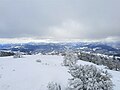 Panoramic view from top of Goč in winter
 -
 Cottage close to evergreen forest
 -
 Evergreen forest in winter
 -
 Lake Selište in fall
 -
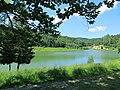 Lake Selište in summer


.jpg)
See also
References
- ^ Jovan Đokić. "Katalog planina Srbije". PSD Kopaonik Beograd. Archived from the original on 2011-05-18.
- ^ "Planina Goč". goc.rs (in Serbian). Retrieved 2023-05-24.
- ^ Ski staze (in Serbian), Smučarski klub Goč, retrieved 2010-10-13
External links
| Settlements |  | |
|---|---|---|
| Landmarks | ||
| Culture | ||
| Notable people | ||
|
| This Serbia location article is a stub. You can help Wikipedia by expanding it. |