(Redirected from
Southeastern Connecticut Planning Region)
Southeastern Connecticut Planning Region | |
|---|---|
Planning region | |
| Southeastern Connecticut Council of Governments (SCCOG) | |
  _passes_by_the_historic_ship_USS_Nautilus.jpg)   | |
|
Logo | |
 Location within the U.S. state of
Connecticut | |
 Connecticut's location within the
U.S. | |
| Coordinates: 41°29′N 72°05′W / 41.49°N 72.09°W | |
| Country | |
| State | |
| Founded | 1992 [1] |
| Largest city | Norwich |
| Other cities | New London, Willimantic, Groton |
| Government | |
| • Executive Director | Amanda E. Kennedy |
| Area | |
| • Total | 598.1 sq mi (1,549 km2) |
| Population (
2020) | |
| • Total | 280,430 |
| Time zone | UTC−5 ( Eastern) |
| • Summer ( DST) | UTC−4 ( EDT) |
| Congressional district | 2nd |
| Website |
seccog |
The Southeastern Connecticut Planning Region is a planning region and county-equivalent in Connecticut. It is served by the coterminous Southeastern Connecticut Council of Governments (SCCOG). In 2022, planning regions were approved to replace Connecticut's counties as county-equivalents for statistical purposes, with full implementation occurring by 2024. [2] [3]
Demographics
| Census | Pop. | Note | %± |
|---|---|---|---|
| 2010 | 290,198 | — | |
| 2020 | 280,430 | −3.4% | |
| 2022 (est.) | 280,403 | [4] | 0.0% |
| U.S. Decennial Census [3] | |||
As of the 2020 United States census, there were 280,430 people living in the Southeastern Planning Region. [3]
Municipalities
The following municipalities are members of the Southeastern Connecticut Region: [5]
Cities
Towns
- Bozrah
- Colchester
- East Lyme
- Franklin
- Griswold
- Groton
- Jewett City
- Lebanon
- Ledyard
- Lisbon
- Montville
- North Stonington
- Preston
- Salem
- Sprague
- Stonington
- Waterford
- Windham
References
- ^ https://seccog.org/
- ^ "Governor Lamont Announces U.S. Census Bureau Approves Proposal for Connecticut's Planning Regions To Become County Equivalents". CT.gov. Retrieved March 24, 2023.
- ^ a b c "Change to County-Equivalents in the State of Connecticut". Federal Register. June 6, 2022. Retrieved March 24, 2023.
- ^ "U.S. Census Bureau QuickFacts: Southeastern Connecticut Planning Region, Connecticut; United States". www.census.gov. Retrieved May 13, 2023.
- ^ "SCCOG Members". Southeastern Connecticut Council of Governments. Retrieved March 24, 2023.
External links
Wikimedia Commons has media related to
Southeastern Connecticut Planning Region, Connecticut.
Municipalities and communities of
Southeastern Connecticut Planning Region, Connecticut, United States | ||
|---|---|---|
| Cities | 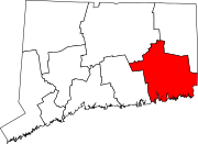 | |
| Towns | ||