40°48′58″N 73°53′39″W / 40.81611°N 73.89417°W
| South Bronx Greenway | |
|---|---|
 2007 planning map | |
| Length | 10 miles (16 km) |
| Established | 2006 |
| Use | Multi-use, bicycle and pedestrian |
The South Bronx Greenway is a project to improve waterfront access, recreational facilities, and transportation systems, including pedestrian and bicycle paths, in the South Bronx in New York City. [1]
Early planning
The project was first envisioned by Majora Carter of The Point Community Development Corporation in the late 1990s as part of a $1.25 million federal transportation grant application. [2] It was formally proposed in the Hunts Point Vision Plan of 2004 and announced by Michael Bloomberg in 2006. [3] [4] In 2014, it was estimated that the total project cost would be $48 million. [5] By 2012, enough of the greenway had been built that New York magazine described it as "transformative". [6]
A three year, $300,000 grant by the Barry Segal Family Foundation funded two Greenway Steward positions. The stewards provided education, outreach, and tree care, as well as construction of street furniture in the area. [7] Sustainable South Bronx also committed $20 million to the nascent project. [8]
Hunts Point Riverside Park

The first section of the greenway to be built was Hunts Point Riverside Park, with construction begun in 2004 and completed in May 2007. [9] [10] The park occupies 1.72 acres (0.70 ha) and is located at the foot of Lafayette Ave between Edgewater Road and the Bronx River. [11] The park includes a fishing pier, kayak and canoe launching area, a playground, and amphitheater. The project won the 2009 Rudy Bruner Award (silver medal) for "restoring an underserved neighborhood's access to the river". [10]
Hunts Point Landing
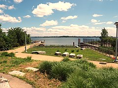
The Greenway includes Hunts Point Landing, a park which opened in 2012. The size is cited as 1 acre (0.40 ha) or 1.5 acres (0.61 ha) by various sources. [12] [13] Located at the end of Farragut Street, which was partially demapped, the park includes a fishing pier, and a canoe and kayak launch area providing access to the East River. [12] [14] Granite recycled from the Willis Avenue Bridge when it was replaced in 2005 was used to construct seating in the new park. [15] [16]
Reflecting the land's previous use as a street, it has an 825 foot (251 m) by 100 foot (30 m) outline. [13] The facility suffers from poor pedestrian access, with park users required to "cross wide, desolate streets and contend with truck traffic." [12]
Hunts Point Landing was awarded the 2016 Merit Award by New York City chapter of the American Society of Landscape Architects. The society noted that the park provides "vital public open space and access to the South Bronx shoreline" as well as creating inter-tidal marshes and a pool to control stormwater runoff, and connection to the greenway. [17] An artificial reef constructed using Reef Ball technology provides a habitat for oysters and mussels. [14] The park has been cited as one of the major accomplishments of the Urban Waters Federal Partnership as part of the Bronx RIver Shoreline Restoration project. [18]
-
 Overlooking the tidal pool towards the East River
 -
 Seating area
 -
 Granite blocks reused from Willis Avenue Bridge


Food Center Drive

The Greenway includes a bikeway parallel to Food Center Drive which was constructed in 2015. This project required remapping Food Center Drive to be a city street, converting it to one-way traffic, and repurposing one traffic lane as the bikeway. [19] The bikeway is separated from the road by a raised curb and rows of trees. [20]
Although some local businesses were opposed to the project, Community Board 2 unanimously supported the plan. Josephine Infante of the Hunts Point Economic Development Corporation noted that the objection was specifically about converting the street to one-way traffic, while supporting the broader Greenway project. [19]
Randalls Island Connector
_006_-_Hell_Gate_Pathway.jpg)
One of the key components of the Greenway is the Randalls Island Connector, [21] which was completed in 2016. [22] This provides a pedestrian and bicycle path from Randalls Island to the Mott Haven neighborhood in the Bronx. This, along with the Wards Island Bridge, creates a route between the Bronx and Manhattan that is completely segregated from vehicular traffic and free from steps. [23] Project cost was $3.6 million. [24]
The connector crosses the Bronx Kill which separates the South Bronx from Randalls Island. Completing the project required obtaining an easement to cross privately controlled land. [25] The land is owned by New York State, but leased for 99 years to Harlem River Yards Ventures, which in turn sublet portions of the property to the New York Post, Waste Management, FedEx and FreshDirect. An additional problem was debris from the overhead rail line falling onto the ground. This was resolved by installing netting. [26]
The Randalls Island Connector earned the 2019 Honor Award for Landscape Architectural Site Design from the New Jersey chapter of the American Society of Landscape Architects. The award recognizes the 0.25-mile (0.40 km) long project for linking residents of the South Bronx with the 330 acres (130 ha) of sports fields on Randalls Island. [27]
An earlier incarnation of the concept was announced in 2001, when the New York Power Authority proposed to build a footbridge over the Kill, and had approved obtaining $500,000 in financing. The project never got out of the early design stage, and no specific location had been set. [28]
References
- ^ "South Bronx Greenway". NYCEDC. Archived from the original on March 15, 2018. Retrieved February 1, 2018.
- ^ Niemetz, Alexandra (December 19, 2011). "South Bronx Greenway makes s-l-o-w progress". Hunts Point Express. Archived from the original on July 28, 2021. Retrieved July 28, 2021.
- ^ Hunts Point Task Force (Fall 2004). "Hunts Point Vision Plan" (PDF). New York City Economic Development Corporation. Archived (PDF) from the original on May 16, 2020. Retrieved July 28, 2021.
- ^ "Mayor Bloomberg Unveils South Bronx Greenway Plan". The official website of the City of New York. Archived from the original on February 2, 2018. Retrieved February 1, 2018.
- ^ Small, Eddie (July 17, 2014). "Pedestrian Bridge From Bronx to Randall's Island Should Open Soon". DNAinfo New York. Archived from the original on June 12, 2019. Retrieved July 28, 2021.
- ^ Davidson, Justin (May 3, 2012). "When the House is the Yard". New York Magazine. Archived from the original on January 24, 2021. Retrieved July 28, 2021.
- ^ "South Bronx Greenway Stewards". Clinton Foundation. Archived from the original on September 28, 2020. Retrieved July 28, 2021.
-
^ News 12 Staff (August 17, 2007).
"Stewards turn Hunts Point into 'green ghetto'". News 12 – Westchester.
Archived from the original on July 28, 2021. Retrieved July 28, 2021.
{{
cite web}}
: CS1 maint: numeric names: authors list ( link) - ^ Steinhauer, Jennifer (July 20, 2004). "Illegal Dump in South Bronx to Become a Park". The New York Times. ISSN 0362-4331. Retrieved August 4, 2021.
- ^ a b "Hunts Point Riverside Park". Rudy Bruner Award.
- ^ Farbstein, Jay (2009). "2009 Rudy Bruner Award: Silver Medal Winner. Hunts Point Riverside Park" (PDF). Bruner Foundation.
- ^ a b c Milner, Kimberly Devi (August 1, 2012). "New Park to Open Near Fish Market". The Hunts Point Express. Archived from the original on July 28, 2021. Retrieved July 28, 2021.
- ^ a b "Hunts Point Landing | SITES". www.sustainablesites.org. Archived from the original on April 26, 2021. Retrieved July 28, 2021.
- ^ a b Kimmelman, Michael (July 19, 2012). "River of Hope in the Bronx". The New York Times. ISSN 0362-4331. Archived from the original on May 6, 2021. Retrieved July 28, 2021.
- ^ Vinnitskaya, Irina (June 6, 2012). "A Lesson in Dedicated Collaboration: Hunts Point Landing on the South Bronx Greenway / Mathews Nielsen Landscape Architects". ArchDaily. Archived from the original on March 3, 2021. Retrieved July 28, 2021.
- ^ Dillon, Kit (September 25, 2012). "EDC and Congressman Serrano Open Hunts Point Landing Park, Go Kayaking". Observer. Archived from the original on November 25, 2020. Retrieved July 28, 2021.
- ^ "Hunts Point Landing | ASLA-NY". Archived from the original on October 30, 2020. Retrieved July 28, 2021.
- ^ Urban Waters Federal Partnership (August 2017). "Bronx and Harlem River Watersheds" (PDF). United States Environmental Protection Agency. Archived (PDF) from the original on July 28, 2021. Retrieved July 28, 2021.
- ^ a b "South Bronx Greenway Takes Shape on Food Center Drive". Streetsblog New York City. June 15, 2015. Archived from the original on January 16, 2021. Retrieved July 28, 2021.
- ^ Cohen, Ilana (November 24, 2015). "Designing New York City's Cycling Infrastructure". Metropolis magazine. Archived from the original on August 8, 2020. Retrieved July 28, 2021.
- ^ Hu, Winnie (July 28, 2015). "Connector Between Randalls Island and Bronx Is to Open This Summer". The New York Times. Archived from the original on June 14, 2018. Retrieved February 1, 2018.
- ^ Hu, Winnie; Rojas, Rick (May 14, 2016). "Starving for Greenery, the South Bronx Finally Gets a Link to Randalls Island". The New York Times. Archived from the original on February 2, 2018. Retrieved February 1, 2018.
- ^ Del Signore, John (January 31, 2011). "Randall's Island Bike Path To Connect to South Bronx Greenway". Gothamist. Archived from the original on February 25, 2018. Retrieved February 1, 2018.
- ^ Ashaboglu, Selin (January 21, 2016). "Randalls Island Connector". Architect Magazine. Archived from the original on January 22, 2021. Retrieved July 28, 2021.
- ^ Beekman, Daniel (January 24, 2012). "Randalls Island Connector could become bridge to nowhere due to muddy South Bronx property deal". Daily News. New York. Archived from the original on February 22, 2017. Retrieved July 28, 2021.
- ^ "Pact will let city build bridge to Randall's Island". Mott Haven Herald. May 21, 2012. Archived from the original on February 27, 2021. Retrieved July 28, 2021.
- ^ Wolock, Steven. "Randall's Island Connector". NJASLA. Archived from the original on November 25, 2020. Retrieved July 28, 2021.
- ^ Koh, Eun Lee (March 4, 2001). "NEIGHBORHOOD REPORT: MOTT HAVEN; Not Merely a Footbridge, but a Path to a Rare Oasis". The New York Times. ISSN 0362-4331. Archived from the original on March 4, 2016. Retrieved July 28, 2021.
External links
- "A Hunt's Point Walk: Part 2". bronx river sankofa. September 3, 2014. Retrieved February 4, 2021.
- "Maintenance Funding Recommendations for the South Bronx Greenway | Columbia SIPA". sipa.columbia.edu. Retrieved February 4, 2021.
- South Bronx Greenway, Jonathan Rose Companies
- South Bronx Greenway, Mathews Nielsen Landscape Architects