Snowdoun, Alabama | |
|---|---|
 Snowdoun  Snowdoun | |
| Coordinates: 32°14′30″N 86°17′47″W / 32.24167°N 86.29639°W | |
| Country | United States |
| State | Alabama |
| County | Montgomery |
| Elevation | 282 ft (86 m) |
| Time zone | UTC-6 ( Central (CST)) |
| • Summer ( DST) | UTC-5 (CDT) |
| Area code | 334 |
| GNIS feature ID | 127083 [1] |
Snowdoun is an unincorporated community in Montgomery County, Alabama, United States. Snowdoun is located on U.S. Highway 331 9.5 miles (15.3 km) south of Montgomery.
History
Snowdoun was named by William Falconer in honor of Mount Snowdon in Wales. [2] A post office operated under the name Snowdoun from 1859 to 1957. [3] Snowdoun is located along the route of the Federal Road. [4]
Snowdoun was formerly connected to Montgomery by the Montgomery Southern Railway, a narrow gauge railway. [5]
William Bartram camped near Snowdoun on his expedition through the southern colonies. [6]
References
- ^ "Snowdoun". Geographic Names Information System. United States Geological Survey, United States Department of the Interior.
- ^ Foscue, Virginia (1989). Place Names in Alabama. Tuscaloosa: The University of Alabama Press. p. 129. ISBN 0-8173-0410-X.
- ^ "Montgomery County". Jim Forte Postal History. Retrieved January 19, 2015.
- ^ Braund, Kathryn; Waselkov, Gregory; Christopher, Raven (2019). The Old Federal Road in Alabama. Tuscaloosa: University of Alabama Press. p. 116. ISBN 978-0-8173-5930-0.
- ^ George Woodman Hilton (1990). American Narrow Gauge Railroads. Stanford University Press. p. 304. ISBN 978-0-8047-1731-1.
- ^ Bartram Trail Conference (1979). Bartram Heritage. Brad Sanders. p. 134. GGKEY:LPJW3TZ54Y4.
Municipalities and communities of
Montgomery County, Alabama, United States | ||
|---|---|---|
| Cities | 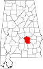 | |
| Towns | ||
|
Unincorporated communities | ||
| Indian reservation | ||
| Footnotes | ‡This populated place also has portions in an adjacent county or counties | |
|
| This Montgomery County, Alabama state location article is a stub. You can help Wikipedia by expanding it. |