Cecil, Alabama | |
|---|---|
 Cecil  Cecil | |
| Coordinates: 32°18′10″N 86°00′31″W / 32.30278°N 86.00861°W | |
| Country | United States |
| State | Alabama |
| County | Montgomery |
| Elevation | 239 ft (73 m) |
| Time zone | UTC-6 ( Central (CST)) |
| • Summer ( DST) | UTC-5 (CDT) |
| ZIP code | 36013 |
| Area code | 334 |
| GNIS feature ID | 115733 [1] |
Cecil is an unincorporated community in Montgomery County, Alabama, United States. Cecil is located on Alabama State Route 110, 17.6 miles (28.3 km) east-southeast of Montgomery. Cecil had a post office until it closed on May 20, 1986; it still has its own ZIP code, 36013. [2] [3]
Education
Macon East Academy, a private PK-12 school, serves Cecil as well as Montgomery Public Schools.
References
- ^ "Cecil". Geographic Names Information System. United States Geological Survey, United States Department of the Interior.
- ^ United States Postal Service (2012). "USPS - Look Up a ZIP Code". Retrieved February 15, 2012.
- ^ "Postmaster Finder - Post Offices by ZIP Code". United States Postal Service. Archived from the original on April 28, 2019. Retrieved June 5, 2013.
Municipalities and communities of
Montgomery County, Alabama, United States | ||
|---|---|---|
| Cities | 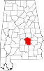 | |
| Towns | ||
|
Unincorporated communities | ||
| Indian reservation | ||
| Footnotes | ‡This populated place also has portions in an adjacent county or counties | |
|
| This Montgomery County, Alabama state location article is a stub. You can help Wikipedia by expanding it. |