PhotosLocation


Schwerin,_Brandenburg Latitude and Longitude:

52°09′N 13°38′E / 52.150°N 13.633°E / 52.150; 13.633
From Wikipedia, the free encyclopedia
Schwerin
Location of Schwerin within Dahme-Spreewald district
Alt Zauche-Wußwerk Bersteland Bestensee Byhleguhre-Byhlen Drahnsdorf Eichwalde Golßen Groß Köris Halbe Heideblick Heidesee Jamlitz Kasel-Golzig Königs Wusterhausen Krausnick-Groß Wasserburg Lieberose Lübben Luckau Märkisch Buchholz Märkische Heide Mittenwalde Münchehofe Neu Zauche Rietzneuendorf-Staakow Schlepzig Schönefeld Schönwald Schulzendorf Schwerin Schwielochsee Spreewaldheide Steinreich Straupitz (Spreewald) Teupitz Unterspreewald Wildau Zeuthen Brandenburg
Schwerin is located in Germany
Schwerin
Schwerin
Schwerin is located in Brandenburg
Schwerin
Schwerin
Coordinates: 52°09′N 13°38′E / 52.150°N 13.633°E / 52.150; 13.633
Country Germany
State Brandenburg
District Dahme-Spreewald
Municipal assoc. Schenkenländchen
Government
 •  Mayor (2019–24) Heinz Gode [1]
Area
 • Total6.69 km2 (2.58 sq mi)
Elevation
38 m (125 ft)
Population
 (2022-12-31) [2]
 • Total926
 • Density140/km2 (360/sq mi)
Time zone UTC+01:00 ( CET)
 • Summer ( DST) UTC+02:00 ( CEST)
Postal codes
15755
Dialling codes033766
Vehicle registrationLDS
Website www.amt-schenkenlaendchen.de

Schwerin is a municipality in the district of Dahme-Spreewald in Brandenburg in Germany.
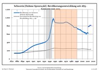
Demography

Development of population since 1875 within the current boundaries (Blue line: Population; Dotted line: Comparison to population development of Brandenburg state; Grey background: Time of Nazi rule; Red background: Time of communist rule)
Schwerin [Dahme-Spreewald]: Population development
within the current boundaries (2017) [3]
Year Pop. ±% p.a.
1875 136—    
1890 155+0.88%
1910 316+3.63%
1925 378+1.20%
1933 420+1.33%
1939 521+3.66%
1946 966+9.22%
1950 885−2.17%
1964 871−0.11%
1971 892+0.34%
1981 815−0.90%
1985 766−1.54%
1989 762−0.13%
1990 749−1.71%
Year Pop. ±% p.a.
1991 727−2.94%
1992 728+0.14%
1993 725−0.41%
1994 712−1.79%
1995 709−0.42%
1996 702−0.99%
1997 706+0.57%
1998 683−3.26%
1999 677−0.88%
2000 665−1.77%
2001 659−0.90%
2002 651−1.21%
2003 652+0.15%
2004 629−3.53%
Year Pop. ±% p.a.
2005 643+2.23%
2006 629−2.18%
2007 602−4.29%
2008 613+1.83%
2009 637+3.92%
2010 630−1.10%
2011 780+23.81%
2012 794+1.79%
2013 792−0.25%
2014 815+2.90%
2015 814−0.12%
2016 815+0.12%
2017 820+0.61%

References

  1. ^ Landkreis Dahme-Spreewald Wahl der Bürgermeisterin / des Bürgermeisters, accessed 30 June 2021.
  2. ^ "Bevölkerungsentwicklung und Bevölkerungsstandim Land Brandenburg Dezember 2022" (PDF). Amt für Statistik Berlin-Brandenburg (in German). June 2023.
  3. ^ Detailed data sources are to be found in the Wikimedia Commons. Population Projection Brandenburg at Wikimedia Commons