PhotosLocation


Spreewaldheide Latitude and Longitude:

51°57′00″N 14°07′59″E / 51.95000°N 14.13306°E / 51.95000; 14.13306
From Wikipedia, the free encyclopedia
Spreewaldheide
Location of Spreewaldheide within Dahme-Spreewald district
Alt Zauche-Wußwerk Bersteland Bestensee Byhleguhre-Byhlen Drahnsdorf Eichwalde Golßen Groß Köris Halbe Heideblick Heidesee Jamlitz Kasel-Golzig Königs Wusterhausen Krausnick-Groß Wasserburg Lieberose Lübben Luckau Märkisch Buchholz Märkische Heide Mittenwalde Münchehofe Neu Zauche Rietzneuendorf-Staakow Schlepzig Schönefeld Schönwald Schulzendorf Schwerin Schwielochsee Spreewaldheide Steinreich Straupitz (Spreewald) Teupitz Unterspreewald Wildau Zeuthen Brandenburg
Spreewaldheide is located in Germany
Spreewaldheide
Spreewaldheide
Spreewaldheide is located in Brandenburg
Spreewaldheide
Spreewaldheide
Coordinates: 51°57′00″N 14°07′59″E / 51.95000°N 14.13306°E / 51.95000; 14.13306
Country Germany
State Brandenburg
District Dahme-Spreewald
Municipal assoc. Lieberose/Oberspreewald
Government
 •  Mayor (2024–29) Daniel Zimmer [1] ( CDU)
Area
 • Total35.99 km2 (13.90 sq mi)
Elevation
54 m (177 ft)
Population
 (2022-12-31) [2]
 • Total453
 • Density13/km2 (33/sq mi)
Time zone UTC+01:00 ( CET)
 • Summer ( DST) UTC+02:00 ( CEST)
Postal codes
15913
Dialling codes035475
Vehicle registrationLDS

Spreewaldheide is a municipality in the district of Dahme-Spreewald in Brandenburg in Germany.
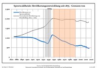
Demography

Development of population since 1875 within the current boundaries (Blue line: Population; Dotted line: Comparison to population development of Brandenburg state; Grey background: Time of Nazi rule; Red background: Time of communist rule)
Spreewaldheide: Population development
within the current boundaries (2017) [3]
Year Pop. ±% p.a.
1875 1,064—    
1890 1,042−0.14%
1910 1,014−0.14%
1925 843−1.22%
1933 783−0.92%
1939 733−1.09%
1946 1,141+6.53%
1950 1,127−0.31%
1964 871−1.82%
1971 813−0.98%
1981 672−1.89%
1985 650−0.83%
1989 603−1.86%
1990 591−1.99%
Year Pop. ±% p.a.
1991 587−0.68%
1992 589+0.34%
1993 593+0.68%
1994 585−1.35%
1995 595+1.71%
1996 604+1.51%
1997 600−0.66%
1998 616+2.67%
1999 606−1.62%
2000 617+1.82%
2001 615−0.32%
2002 608−1.14%
2003 594−2.30%
2004 580−2.36%
Year Pop. ±% p.a.
2005 569−1.90%
2006 568−0.18%
2007 567−0.18%
2008 549−3.17%
2009 531−3.28%
2010 544+2.45%
2011 499−8.27%
2012 486−2.61%
2013 485−0.21%
2014 472−2.68%
2015 464−1.69%
2016 464+0.00%
2017 480+3.45%

References

  1. ^ Landkreis Dahme-Spreewald Wahl der Bürgermeisterin / des Bürgermeisters. Retrieved 27 June 2024.
  2. ^ "Bevölkerungsentwicklung und Bevölkerungsstandim Land Brandenburg Dezember 2022" (PDF). Amt für Statistik Berlin-Brandenburg (in German). June 2023.
  3. ^ Detailed data sources are to be found in the Wikimedia Commons. Population Projection Brandenburg at Wikimedia Commons