Scherpenisse | |
|---|---|
Village | |
 Former town hall | |
 Flag  Coat of arms | |
 Scherpenisse Location in the province of Zeeland in the Netherlands  Scherpenisse Scherpenisse (Netherlands) | |
| Coordinates: 51°32′48″N 4°6′18″E / 51.54667°N 4.10500°E | |
| Country | Netherlands |
| Province | Zeeland |
| Municipality | Tholen |
| Area | |
| • Total | 21.34 km2 (8.24 sq mi) |
| Elevation | 2.9 m (9.5 ft) |
| Population (2021)
[1] | |
| • Total | 1,550 |
| • Density | 73/km2 (190/sq mi) |
| Time zone | UTC+1 ( CET) |
| • Summer ( DST) | UTC+2 ( CEST) |
| Postal code | 4521
[1] |
| Dialing code | 0115 |
Scherpenisse is a village in the Dutch province of Zeeland. It is a part of the municipality of Tholen, and lies about 14 km west of Bergen op Zoom.
History
It was first mentioned in 1204 as Scarpenes, and means "sharp headland". [3] Scherpenisse developed along the former trench Pluimpot. The area became property of the House of Orange in 1551. In 1556, the Pluimpot was dammed, and the main buildings were constructed between the dam and the church. [4]
The Dutch Reformed is a basilica like church with a thick tower. The church probably dates from the 15th century. Construction of the tower started in 1520, but was halted in 1570. The church was restored between 1971 and 1974. [4] The church is located off-centre, because a part of the village burnt down in 1538, and was rebuilt closer to the harbour. [5]
The former town hall was constructed in 1594 as a gift of Countess Maria of Nassau. The building is in mannerist style and has a ridge turret with clock. [4]
Scherpenisse was home to 935 people in 1840. [6] Scherpenisse was a separate municipality until 1971, when it was merged with Tholen. [7] In 1957, as part of the Delta Works, the remainder of the Pluimpot was filled up, and the harbour of Scherpenisse disappeared. [4]
Gallery
-
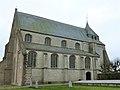 Dutch Reformed church
 -
 Hotel-restaurant De Gouden Leeuw
 -
 Water tower
 -
 Shops in Scherpenisse
5.JPG)


References
- ^
a
b
c
"Kerncijfers wijken en buurten 2021". Central Bureau of Statistics. Retrieved 22 April 2022.
two entries
- ^ "Postcodetool for 4521AA". Actueel Hoogtebestand Nederland (in Dutch). Het Waterschapshuis. Retrieved 22 April 2022.
- ^ "Scherpenisse - (geografische naam)". Etymologiebank (in Dutch). Retrieved 22 April 2022.
- ^ a b c d Piet van Cruyningen & Ronald Stenvert (2003). Scherpenisse (in Dutch). Zwolle: Waanders. ISBN 90 400 8830 6. Retrieved 22 April 2022.
- ^ "Scherpenisse". Zalig Zeeland (in Dutch). Retrieved 22 April 2022.
- ^ "Scherpenisse". Plaatsengids (in Dutch). Retrieved 22 April 2022.
- ^ Ad van der Meer and Onno Boonstra, Repertorium van Nederlandse gemeenten, KNAW, 2011.