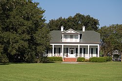
Sandbar Plantation House | |
 The Sandbar Plantation House in 2014 | |
| Nearest city | Port Allen, Louisiana |
|---|---|
| Coordinates | 30°24′31″N 91°13′2″W / 30.40861°N 91.21722°W |
| Area | 3.1 acres (1.3 ha) |
| Architectural style | Greek Revival, Colonial Revival |
| NRHP reference No. | 99001039 [1] |
| Added to NRHP | September 2, 1999 |
The Sandbar Plantation is a historic plantation with a mansion in Port Allen, Louisiana, U.S.. It was built circa 1837 for Dr. Thomas Philander and his wife, Marie Aureline Vaughan. [2] It was purchased by Chas. H. Dameron in 1925. [2] It has been listed on the National Register of Historic Places since September 2, 1999. [3]
References
- ^ "National Register Information System". National Register of Historic Places. National Park Service. July 9, 2010.
- ^ a b "Sandbar Plantation House". West Baton Rouge Museum. Retrieved August 22, 2016.
- ^ "Sandbar Plantation House". National Park Service. Retrieved August 22, 2016.
Categories:
- Houses on the National Register of Historic Places in Louisiana
- Houses completed in 1837
- Greek Revival architecture in Louisiana
- Colonial Revival architecture in Louisiana
- National Register of Historic Places in West Baton Rouge Parish, Louisiana
- Plantations in Louisiana
- Plantation houses in Louisiana
- 1837 establishments in Louisiana
- Houses in West Baton Rouge Parish, Louisiana
- Louisiana Registered Historic Place stubs
