Sablan | |
|---|---|
| Municipality of Sablan | |
 Street in Sablan | |
 Flag  Seal | |
 Map of Benguet with Sablan highlighted | |
.svg) Sablan Location within the
Philippines | |
| Coordinates: 16°29′48″N 120°29′15″E / 16.4967°N 120.4875°E | |
| Country | Philippines |
| Region | Cordillera Administrative Region |
| Province | Benguet |
| District | Lone district |
| Barangays | 8 (see Barangays) |
| Government | |
| • Type | Sangguniang Bayan |
| • Mayor | Alfredo B. Dacumos Jr. |
| • Vice Mayor | Arthur C. Baldo |
| • Representative | Nestor B. Fongwan |
| • Electorate | 8,333 voters ( 2022) |
| Area | |
| • Total | 105.63 km2 (40.78 sq mi) |
| Elevation | 497 m (1,631 ft) |
| Highest elevation | 1,117 m (3,665 ft) |
| Lowest elevation | 51 m (167 ft) |
| Population (2020 census)
[3] | |
| • Total | 11,588 |
| • Density | 110/km2 (280/sq mi) |
| • Households | 2,819 |
| Economy | |
| • Income class | 5th municipal income class |
| • Poverty incidence | 8.71 |
| • Revenue | ₱ 88 million (2020) |
| • Assets | ₱ 216.7 million (2020) |
| • Expenditure | ₱ 70.75 million (2020) |
| • Liabilities | ₱ 43.28 million (2020) |
| Service provider | |
| • Electricity | Benguet Electric Cooperative (BENECO) |
| Time zone | UTC+8 ( PST) |
| ZIP code | 2614 |
| PSGC | |
| IDD : area code | +63 (0)74 |
| Native languages | Kankanaey Ibaloi Ilocano Tagalog |
Sablan, officially the Municipality of Sablan ( Ilocano: Ili ti Sablan; Tagalog: Bayan ng Sablan), is a 5th class municipality in the province of Benguet, Philippines. According to the 2020 census, it has a population of 11,588 people. [3]
Etymology
The term "Sablan" was derived from the local word "Sabdang", a local tree which thrived in the area. [5]
History
Sablan was created officially as a municipal district on July 1, 1927, under Executive Order No. 61 dated May 17, 1927 by then American Governor General Leonard Wood.
Geography
Sablan is at the mid-western tip of Benguet. It is bounded by Kapangan on the north, Tublay on the northeast, La Trinidad on the east, Baguio in the southeast, Tuba in the south, Aringay on the southwest, and Burgos to the west.
According to the Philippine Statistics Authority, the municipality has a land area of 105.63 square kilometres (40.78 sq mi) [6] constituting 3.81% of the 2,769.08-square-kilometre- (1,069.15 sq mi) total area of Benguet.
Sablan is 21 kilometres (13 mi) from Baguio, 26 kilometres (16 mi) from provincial capital La Trinidad, and 285 kilometres (177 mi) from Manila.
Barangays
Sablan is politically subdivided into 8 barangays. [7] Each barangay consists of puroks and some have sitios.
| PSGC | Barangay | Population | ±% p.a. | |||
|---|---|---|---|---|---|---|
| 2020 [3] | 2010 [8] | |||||
| 141112002 | Bagong | 6.2% | 719 | 764 | −0.61% | |
| 141112003 | Balluay | 5.8% | 667 | 507 | 2.78% | |
| 141112004 | Banangan | 17.2% | 1,994 | 1,756 | 1.28% | |
| 141112005 | Banengbeng | 7.7% | 889 | 1,108 | −2.18% | |
| 141112006 | Bayabas | 21.3% | 2,465 | 2,068 | 1.77% | |
| 141112007 | Kamog | 12.8% | 1,488 | 1,064 | 3.41% | |
| 141112010 | Pappa | 5.4% | 624 | 594 | 0.49% | |
| 141112011 | Poblacion | 23.7% | 2,742 | 2,650 | 0.34% | |
| Total | 11,588 | 11,588 | 0.00% | |||
Climate
| Climate data for Sablan, Benguet | |||||||||||||
|---|---|---|---|---|---|---|---|---|---|---|---|---|---|
| Month | Jan | Feb | Mar | Apr | May | Jun | Jul | Aug | Sep | Oct | Nov | Dec | Year |
| Mean daily maximum °C (°F) | 22 (72) |
23 (73) |
24 (75) |
25 (77) |
24 (75) |
23 (73) |
21 (70) |
21 (70) |
21 (70) |
22 (72) |
23 (73) |
22 (72) |
23 (73) |
| Mean daily minimum °C (°F) | 12 (54) |
12 (54) |
14 (57) |
16 (61) |
17 (63) |
16 (61) |
16 (61) |
16 (61) |
16 (61) |
15 (59) |
14 (57) |
12 (54) |
15 (59) |
| Average precipitation mm (inches) | 15 (0.6) |
16 (0.6) |
24 (0.9) |
33 (1.3) |
102 (4.0) |
121 (4.8) |
177 (7.0) |
165 (6.5) |
144 (5.7) |
170 (6.7) |
56 (2.2) |
23 (0.9) |
1,046 (41.2) |
| Average rainy days | 6.3 | 6.6 | 9.5 | 12.8 | 20.6 | 23.5 | 25.4 | 23.4 | 23.2 | 21.4 | 14.0 | 8.2 | 194.9 |
| Source: Meteoblue [9] | |||||||||||||
Demographics
| Year | Pop. | ±% p.a. |
|---|---|---|
| 1939 | 2,930 | — |
| 1948 | 2,786 | −0.56% |
| 1960 | 4,741 | +4.53% |
| 1970 | 5,681 | +1.82% |
| 1975 | 7,345 | +5.29% |
| 1980 | 7,900 | +1.47% |
| 1990 | 8,440 | +0.66% |
| 1995 | 9,170 | +1.57% |
| 2000 | 9,652 | +1.10% |
| 2007 | 10,890 | +1.68% |
| 2010 | 10,511 | −1.28% |
| 2015 | 11,457 | +1.65% |
| 2020 | 11,588 | +0.22% |
| Source: Philippine Statistics Authority [10] [8] [11] [12] | ||
In the 2020 census, Sablan had a population of 11,588. [3] The population density was 110 inhabitants per square kilometre (280/sq mi).
Economy
Graphs are unavailable due to technical issues. There is more info on
Phabricator and on
MediaWiki.org. |
Government
Local government
Sablan, belonging to the lone congressional district of the province of Benguet, is governed by a mayor designated as its local chief executive and by a municipal council as its legislative body in accordance with the Local Government Code. The mayor, vice mayor, and the councilors are elected directly by the people through an election which is being held every three years.
Elected officials
| Position | Name |
|---|---|
| Congressman | Eric G. Yap |
| Mayor | Alfredo B.Dacumos Jr. |
| Vice-Mayor | Arthur C. Baldo |
| Councilors | Johny C. Cutay |
| Harold H. Busoy | |
| Cesar B. Calado | |
| Romeo P. Amboy | |
| Jefferson I. Carame | |
| Cornelio I. Almacen | |
| Jerry W. Olanio | |
| Arthur F. De Leon |
Education
Public schools
As of 2014, Sablan has 14 public elementary schools and 2 public secondary schools. [21] [22] [23]
|
|
Private schools
Saint Louis School of Sablan is the only private secondary school in the municipality, located at Barangay Poblacion.
Transportation
Major roads within the Sablan include the Naguilian Road (formerly Quirino Highway) and Asin–Nangalisan–San Pascual Road.
Gallery
-
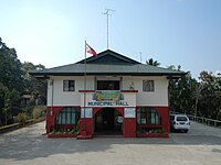 Municipal hall
 -
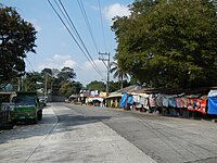
 Downtown Sablan
 -
 Fruit and souvenir stalls along Naguilian Road
 -
 Immaculate Conception Parish Church
 -
 Rural landscape


Notes
References
- ^ Municipality of Sablan | (DILG)
- ^ "2015 Census of Population, Report No. 3 – Population, Land Area, and Population Density" (PDF). Philippine Statistics Authority. Quezon City, Philippines. August 2016. ISSN 0117-1453. Archived (PDF) from the original on May 25, 2021. Retrieved July 16, 2021.
- ^ a b c d Census of Population (2020). "Cordillera Administrative Region (CAR)". Total Population by Province, City, Municipality and Barangay. Philippine Statistics Authority. Retrieved 8 July 2021.
- ^ "PSA Releases the 2018 Municipal and City Level Poverty Estimates". Philippine Statistics Authority. 15 December 2021. Retrieved 22 January 2022.
- ^ "Municipality of Sablan, Benguet profile". DILG - CAR. Department of the Interior and Local Government (Philippines). Retrieved 16 September 2014.
- ^ "Province: Benguet". PSGC Interactive. Quezon City, Philippines: Philippine Statistics Authority. Retrieved 12 November 2016.
- ^ "Municipal: Sablan, Benguet". PSGC Interactive. Quezon City, Philippines: Philippine Statistics Authority. Retrieved 8 January 2016.
- ^ a b Census of Population and Housing (2010). "Cordillera Administrative Region (CAR)" (PDF). Total Population by Province, City, Municipality and Barangay. National Statistics Office. Retrieved 29 June 2016.
- ^ "Sablan: Average Temperatures and Rainfall". Meteoblue. Retrieved 21 March 2020.
- ^ Census of Population (2015). "Cordillera Administrative Region (CAR)". Total Population by Province, City, Municipality and Barangay. Philippine Statistics Authority. Retrieved 20 June 2016.
-
^ Censuses of Population (1903–2007).
"Cordillera Administrative Region (CAR)".
Table 1. Population Enumerated in Various Censuses by Province/Highly Urbanized City: 1903 to 2007.
National Statistics Office.
{{
cite encyclopedia}}
: CS1 maint: numeric names: authors list ( link) - ^ "Province of Benguet". Municipality Population Data. Local Water Utilities Administration Research Division. Retrieved 17 December 2016.
- ^ "Poverty incidence (PI):". Philippine Statistics Authority. Retrieved December 28, 2020.
- ^ "Estimation of Local Poverty in the Philippines" (PDF). Philippine Statistics Authority. 29 November 2005.
- ^ "2003 City and Municipal Level Poverty Estimates" (PDF). Philippine Statistics Authority. 23 March 2009.
- ^ "City and Municipal Level Poverty Estimates; 2006 and 2009" (PDF). Philippine Statistics Authority. 3 August 2012.
- ^ "2012 Municipal and City Level Poverty Estimates" (PDF). Philippine Statistics Authority. 31 May 2016.
- ^ "Municipal and City Level Small Area Poverty Estimates; 2009, 2012 and 2015". Philippine Statistics Authority. 10 July 2019.
- ^ "PSA Releases the 2018 Municipal and City Level Poverty Estimates". Philippine Statistics Authority. 15 December 2021. Retrieved 22 January 2022.
- ^ "2019 National and Local Elections" (PDF). Commission on Elections. Retrieved March 12, 2022.
- ^ "Masterlist of Public Elementary Schools for the School year 2012- 2013" ( XLSX). Department of Education (Philippines), July 15, 2013. Retrieved 28 December 2014.
- ^ a b "Masterlist of Secondary Schools (School Year 2013- 2014)". Department of Education (Philippines), July 4, 2013. Archived from the original ( XLSX) on 1 July 2014. Retrieved 20 November 2014.
- ^ a b "Masterlist of Public Schools SY 2013-2014" ( XLSX). Department of Education (Philippines), 22 October 2014. Retrieved 28 December 2014.
External links
![]() Media related to
Sablan, Benguet at Wikimedia Commons
Media related to
Sablan, Benguet at Wikimedia Commons
Places adjacent to Sablan, Benguet | |
|---|---|
| Municipalities | |
|---|---|
| Highly urbanized city |
|
| Barangays | |