Coalfields No. 4 | |
|---|---|
| Rural Municipality of Coalfields No. 4 | |
.jpg) | |
 Location of the RM of Coalfields No. 4 in
Saskatchewan | |
| Coordinates: 49°09′00″N 102°39′25″W / 49.150°N 102.657°W [1] | |
| Country | Canada |
| Province | Saskatchewan |
| Census division | 1 |
| SARM division | 1 |
| Federal riding | Souris—Moose Mountain |
| Provincial riding | Estevan |
| Formed [2] | January 1, 1913 |
| Government | |
| • Reeve | Richard Tessier |
| • Governing body | RM of Coalfields No. 4 Council |
| • Administrator | Terry Sernick |
| • Office location | Bienfait |
| Area (2016)
[4] | |
| • Land | 819.52 km2 (316.42 sq mi) |
| Population (2016)
[4] | |
| • Total | 368 |
| • Density | 0.4/km2 (1/sq mi) |
| Time zone | CST |
| • Summer ( DST) | CST |
| Postal code | S0C 0M0 |
| Area code(s) | 306 and 639 |
| Website |
rmofcoalfields |

The Rural Municipality of Coalfields No. 4 ( 2016 population: 368) is a rural municipality (RM) in the Canadian province of Saskatchewan within Census Division No. 1 and SARM Division No. 1. Located in the southeast portion of the province, it is adjacent to the United States, neighbouring Burke County, North Dakota.
History
The RM of Coalfields No. 4 was incorporated as a rural municipality on January 1, 1913. [2]
Geography
The Souris River is the only major river in the RM. It travels from Roche Percée in the west straight across to the east into the neighbouring RM of Enniskillen No. 3. There are no notable lakes in the RM of Coalfields.
Communities and localities
The following urban municipalities are surrounded by the RM.
The following unincorporated communities are within the RM:
Transportation
The two major highways to travers the RM of Coalfields No. 4 are Highway 18 and Highway 39. Municipal highways include Highway 604, Highway 605, Highway 703, and Highway 704.
Demographics
In the 2021 Census of Population conducted by Statistics Canada, the RM of Coalfields No. 4 had a population of 330 living in 133 of its 157 total private dwellings, a change of -10.3% from its 2016 population of 368. With a land area of 818.16 km2 (315.89 sq mi), it had a population density of 0.4/km2 (1.0/sq mi) in 2021. [7]
In the 2016 Census of Population, the RM of Coalfields No. 4 recorded a population of 368 living in 148 of its 183 total private dwellings, a -3.7% change from its 2011 population of 382. With a land area of 819.52 km2 (316.42 sq mi), it had a population density of 0.4/km2 (1.2/sq mi) in 2016. [4]
Government
The RM of Coalfields No. 4 is governed by an elected municipal council and an appointed administrator that meets on the third Thursday of every month. [3] The reeve of the RM is Richard Tessier while its administrator is Terry Sernick. [3] The RM's office is in Bienfait. [3]
Roche Percee Recreation Site
Roche Percee Recreation Site ( 49°04′34″N 102°44′55″W / 49.0762°N 102.7485°W) [8] is a provincial campground in the RM of Coalfields along the Souris River. The park is treed and has a campground with 13 campsites and three picnic areas. The campground has non-electric sites, non- potable water, sewer disposal, and portable toilets. It is downstream and east of the village of Roche Percee and access is from Highway 39. [9]
Gallery
-
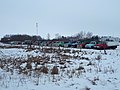 Old cars lined up near Hirsch
 -
 Pumpjacks at dusk on New Year's Day 2022
 -
 Silhouettes of pumpjacks at dusk on New Year's Day 2022
 -
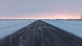 Highway 18 at dawn in winter
 -
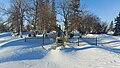 North Portal Cemetery
 -
 Highway 703 intersecting 604


See also
References
- ^ "Pre-packaged CSV files - CGN, Canada/Province/Territory (cgn_sk_csv_eng.zip)". Government of Canada. July 24, 2019. Retrieved May 23, 2020.
- ^ a b "Rural Municipality Incorporations (Alphabetical)". Saskatchewan Ministry of Municipal Affairs. Archived from the original on April 21, 2011. Retrieved May 9, 2020.
- ^ a b c d "Municipality Details: RM of Coalfields No. 4". Government of Saskatchewan. Retrieved May 21, 2020.
- ^ a b c "Population and dwelling counts, for Canada, provinces and territories, and census subdivisions (municipalities), 2016 and 2011 censuses – 100% data (Saskatchewan)". Statistics Canada. February 8, 2017. Retrieved May 1, 2020.
- ^ "Saskatchewan Census Population" (PDF). Saskatchewan Bureau of Statistics. Archived from the original (PDF) on September 24, 2015. Retrieved May 9, 2020.
- ^ "Saskatchewan Census Population". Saskatchewan Bureau of Statistics. Retrieved May 9, 2020.
- ^ "Population and dwelling counts: Canada, provinces and territories, census divisions and census subdivisions (municipalities), Saskatchewan". Statistics Canada. February 9, 2022. Retrieved April 13, 2022.
- ^ "Roche Percee Recreation Site". Canadian Geographical Names Database. Government of Canada. Retrieved December 28, 2023.
- ^ "Roche Percee Campground". Tourism Saskatchewan. Government of Saskatcehwan. Retrieved December 28, 2023.
External links
![]() Media related to
Coalfields No. 4 at Wikimedia Commons
Media related to
Coalfields No. 4 at Wikimedia Commons
Places adjacent to Rural Municipality of Coalfields No. 4 | |
|---|---|
| Cities |  | ||||
|---|---|---|---|---|---|
| Towns | |||||
| Villages | |||||
| Rural municipalities | |||||
| First Nations | |||||
| Indian reserves | |||||
| Unincorporated communities |
| ||||