Rockville, Pennsylvania | |
|---|---|
 The Rockville Bridge over the
Susquehanna River | |
| Coordinates:
| |
| Country | United States |
| State | Pennsylvania |
| County | Dauphin |
| Township | Susquehanna |
| Time zone | UTC-5 ( Eastern (EST)) |
| • Summer ( DST) | UTC-4 (EDT) |
| Area code(s) | 717 and 223 |
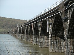
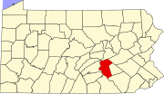
Rockville is an unincorporated community in Susquehanna Township, Dauphin County, Pennsylvania, United States. [1] The community is home to the Rockville Bridge.
Rockville is part of the Harrisburg– Carlisle Metropolitan Statistical Area.
Originally settled in 1774 and referred to as Bushy Rock, the town of Rockville was laid out in 1834 to 1838 as Roberts Valley, by Mrs. Matilda Cox. [2] [3] [4]
References
- ^ U.S. Geological Survey Geographic Names Information System: Rockville, Pennsylvania
- ^ Notes and Queries, Historical, Biographical and Genealogical, Relating Chiefly to Interior Pennsylvania. Harrisburg Publishing Company. 1895. p. 19.
- ^ History of Dauphin County, Pennsylvania, Volume 3. Luther Reily Kelker. 1907. p. 570.
- ^ Steinmetz, Richard H. (1976). This was Harrisburg : a photographic history. Robert D. Hoffsommer. Harrisburg, Pa.: Stackpole Books. pp. 30–31. ISBN 0-8117-1729-1. OCLC 1976122.
External links
Wikimedia Commons has media related to
Rockville, Pennsylvania.
- Pennsylvania's Historical Architecture and Archaeology site photos: [1] [2]
- Rockville Bridge (photos and information)
- Rockville Arch Bridge at Structurae
- Rockville Bridge Photos (November 5, 2005)
40°20′10″N 76°54′18″W / 40.336°N 76.905°W (Rockville Bridge) Rockville is on the west side of the bridge.
- Susquehanna River Statue of Liberty replica images
- Stan's Railpix : Conrail Photo Gallery (Rockville Bridge photos from November 1994)
