Manada Gap, Pennsylvania | |
|---|---|
| Coordinates: 40°23′49″N 76°42′36″W / 40.39694°N 76.71000°W | |
| Country | United States |
| State | Pennsylvania |
| County | Dauphin |
| Township | East Hanover |
| Time zone | UTC-5 ( Eastern (EST)) |
| • Summer ( DST) | UTC-4 (EDT) |
| Official name | Fort Manada |
| Designated | May 12, 1982 [1] |
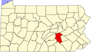
Manada Gap is an unincorporated community in East Hanover Township, Dauphin County, Pennsylvania, United States, located in the Harrisburg- Carlisle area, near Fort Indiantown Gap. [2]
Fort Manada
Fort Manada (also known as James Brown's Fort) was a settler-built stockaded blockhouse established by James Brown in response to Indian attacks in the area, and then improved and commanded by Captain Frederick Smith (Schmitt) as a sub-post of Fort Swatara. Its exact location is unknown, but records indicate that it stood on what was the property of William Rhoads, about 300 yards west of Manada Creek, about midway between it and the road to Jonestown and three-quarters of a mile south of Manada Gap. [3]
Captain Smith and his company were mustered into provincial service early in January 1756 and were ordered to establish a defense or occupy and improve the existing defense at Swatara and Manada. [4]: 341 As in the case of Fort Hunter, the settlers at Manada Gap had already constructed a stockaded blockhouse in late 1755. The garrison, probably around 20 men, was spread between the fort and settlers' homes, protecting the dwellings and the workers in the field. [3]
In February 1756, Captain Frederick Smith, with his company of troops, either completed the fort or built a new one, which they called Fort Manada. [5] James Brown was killed by Indians on 6 August 1756. [3] The fort was in use from late 1755 until May 1757, which is the last time it is mentioned in official documents. [4]: 343
A historical marker was erected in 1970 by the Pennsylvania Historical and Museum Commission in East Hanover Township, on Mountain Road. [6]
References
- ^ "PHMC Historical Markers Search" (Searchable database). Pennsylvania Historical and Museum Commission. Commonwealth of Pennsylvania. Retrieved January 25, 2014.
- ^ U.S. Geological Survey Geographic Names Information System: Manada Gap, Pennsylvania
- ^ a b c Clarence M. Busch, Report of the Commission to Locate the Site of the Frontier Forts of Pennsylvania, Vol. 1, State Printer of Pennsylvania, 1896
- ^ a b Hunter, William Albert. Forts on the Pennsylvania Frontier: 1753–1758, (Classic Reprint). Fb&c Limited, 2018; pp 340-344
- ^ The American Historical Register -. 1894.
- ^ Craig Swain, "Fort Manada," Historical Marker Database, October 15, 2008
- Harrisburg–Carlisle metropolitan statistical area
- Unincorporated communities in Dauphin County, Pennsylvania
- Unincorporated communities in Pennsylvania
- 1755 establishments in Pennsylvania
- British forts in the United States
- Colonial forts in Pennsylvania
- Forts in Pennsylvania
- French and Indian War forts
- Infrastructure completed in 1755
- Geography of Dauphin County, Pennsylvania


