Realicó | |
|---|---|
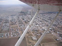
 Aerial view of Realicó | |
| Coordinates: 35°02′20″S 64°14′50″W / 35.03889°S 64.24722°W | |
| Country | |
| Province | |
| Department | Realicó |
| Founded by | Tomás Leopoldo Mullally |
| Government | |
| • Mayor | Javier Facundo Sola ( PJ) |
| Area | |
| • Total | 475 km2 (183 sq mi) |
| Elevation | 146 m (479 ft) |
| Population (2010 census) | |
| • Total | 7,591 |
| • Density | 16/km2 (41/sq mi) |
| Time zone | UTC−3 ( ART) |
| Dialing code | +54 342 |
| Website |
www |

Realicó is a city in La Pampa Province, Argentina. It was founded the second of March in 1907 by Tomás Leopoldo Mullally[ citation needed]. The small farming town has a population of about 7,000[ citation needed]. There is one stoplight, and it is always blinking. A major employer of the town is the Cargill flour mill, although recently the mill's importance has waned, supporting fewer workers as the economy has become more services-oriented. There are three high schools, including a technical school (EPET), a business school, and a private, Catholic school (IPSF). There are also private English schools, including EIR and CELI. Teenagers from neighboring towns flock to Realicó every Saturday night to go to Ladrillo Disco, a popular nightclub.
References
- Murray, Edmundo (2006).
Becoming irlandés: private narratives of the Irish emigration to Argentina ... Google Books. p. 144.
ISBN
9789509725713.
{{
cite book}}
: CS1 maint: location missing publisher ( link)
External links
- City Website (Spanish)
- El Ladrillo Disco (Spanish)

